Login
Register


IPJ
Lincoln County Regional Airport
Official FAA Data Effective 2026-01-22 0901Z
Chart Supplement

VFR Chart of KIPJ
Sectional Charts at SkyVector.com
IFR Chart of KIPJ
Enroute Charts at SkyVector.com
Location Information for KIPJ
Coordinates: N35°28.99' / W81°9.69'Located 05 miles E of Lincolnton, North Carolina on 453 acres of land. View all Airports in North Carolina.
Surveyed Elevation is 877 feet MSL.
Operations Data
|
|
Airport Communications
| AWOS-3: | 119.675 Tel. 704-735-6954 |
|---|---|
| CHARLOTTE APPROACH: | 134.75 257.2 |
| CHARLOTTE DEPARTURE: | 134.75 257.2 |
| CLEARANCE DELIVERY: | 124.9 |
| BOBZY DP: | 134.75 257.2 |
| JOJJO DP: | 134.75 257.2 |
| KILNS DP: | 134.75 257.2 |
| CTAF: | 123.050 |
| BARMY DP: | 134.75 257.2 |
| UNICOM: | 123.050 |
| KWEEN DP: | 134.75 257.2 |
| ESTRR DP: | 134.75 257.2 |
| RASLN STAR: | 126.15 282.325 |
| WEAZL DP: | 134.75 257.2 |
| ICONS DP: | 134.75 257.2 |
| BEAVY DP: | 134.75 257.2 |
| JOOLS STAR: | 135.6 377.15 |
| LILLS DP: | 134.75 257.2 |
| KNIGHTS DP: | 134.75 257.2 |
| KERMIT DP: | 134.75 257.2 |
| ASOS at AKH (17.2 S): | 135.725 704-868-9034 |
| ASOS at CLT (18.6 SE): | 704-255-5973 |
| ASOS at HKY (18.9 NW): | 118.325 828-322-2996 |
Nearby Navigation Aids
|
| ||||||||||||||||||||||||||||||||||||||||||||||||||||||||||||


Runway 05/23
| Dimensions: | 5700 x 100 feet / 1737 x 30 meters 200 FT SWY SW END HAS BEEN REMARKED AS 200 FT DSPLCD THR FOR RWY 5. | |
|---|---|---|
| Surface: | Asphalt in Excellent Condition | |
| Weight Limits: | S-30, D-60 | |
| Edge Lighting: | Medium Intensity | |
| Runway 05 | Runway 23 | |
| Coordinates: | N35°28.67' / W81°10.11' | N35°29.31' / W81°9.27' |
| Elevation: | 877.9 | 863.1 |
| Runway Heading: | 47° True | 227° True |
| Displaced Threshold: | 200 Feet | 199 Feet |
| Markings: | Precision Instrument in good condition. | Precision Instrument in good condition. |
| Glide Slope Indicator | P2L (3.40° Glide Path Angle) | P2L (3.00° Glide Path Angle) |
| REIL: | Yes | Yes |
| Obstacles: | 110 ft Trees 2468 ft from runway, 386 ft left of center APCH SLOPE 18:1 AT DSPLCD THR. |
30 ft Trees 1327 ft from runway, 449 ft left of center APCH SLOPE 31:1 AT DSPLCD THR. DUE TO 11 FT BRUSH 104 FT FR RWY END OFFSET 10-173 FT RIGHT OF CNTRLN; DUE TO 13 FT BRUSH 31-115 FT FR RWY END OFFSET 143-164 FT LEFT OF CNTRLN. |
Services Available
| Fuel: | 100LL (blue), Jet A-1+ |
|---|---|
| Transient Storage: | Tiedowns |
| Airframe Repair: | MAJOR |
| Engine Repair: | MAJOR |
| Bottled Oxygen: | LOW |
| Bulk Oxygen: | LOW |
| Other Services: | PILOT INSTRUCTION,AIRCRAFT RENTAL,AIRCRAFT SALES |
Ownership Information
| Ownership: | Publicly owned | |
|---|---|---|
| Owner: | LINCOLN COUNTY | |
| 714 JACK DELLINGER DRIVE | ||
| IRON STATION, NC 28080 | ||
| 704-735-6002 | ||
| Manager: | SCOTT MAHLER | |
| 714 JACK DELLINGER DRIVE | ||
| IRON STATION, NC 28080 | ||
| 704-764-1100 | ||
Other Remarks
- RWY 23 HAS A 90 FT DROP-OFF 100 FT FM PVMT END AND 90 FT DROP-OFF FIRST 200 FT 160 FT BOTH SIDES OF CNTRLN.
- FOR CD IF UNA VIA GCO CTC CHARLOTTE APCH AT 704-359-0241.
- GCO AVBL ON FREQ 124.900 THRU CHARLOTTE APCH; KEY MIKE 4 TIMES SLOWLY, WAIT FOR DIAL TONE AND RING.
- ARPT PHONE NR 704-735-0602.
- DEER, COYOTE & BIRDS ON & INVOF ARPT.
- TO ACTVT REIL RWY 05 & 23 DUSK-DAWN - CTAF; TO ACTVT PAPI RWY 05 & 23 - CTAF. MIRL RWY 05/23 DUSK TO 2200 PRESET LOW INTST; TO INCR INTST DUSK TO 2200 AND TO ACTVT MIRL RWY 05/23 BETWEEN 2200-DAWN - CTAF.
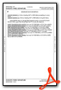
Weather Minimums

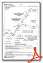
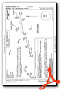
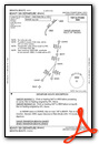
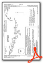
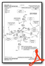
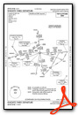
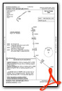
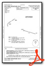
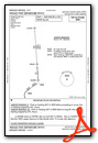
Standard Terminal Arrival (STAR) Charts
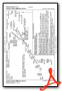

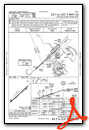
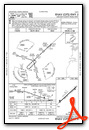
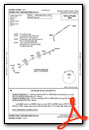
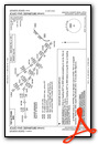
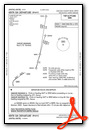
Instrument Approach Procedure (IAP) Charts
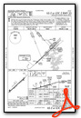
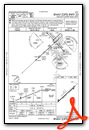
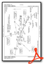
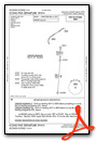
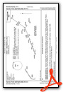
Departure Procedure (DP) Charts

Nearby Airports with Instrument Procedures
| ID | Name | Heading / Distance | ||
|---|---|---|---|---|
 |
14A | Lake Norman Airpark Airport | 058° | 15.0 |
|
KAKH | Gastonia Municipal Airport | 178° | 16.8 |
|
KHKY | Hickory Regional Airport | 324° | 19.1 |
|
KCLT | Charlotte/Douglas International Airport | 147° | 19.2 |
|
KSVH | Statesville Regional Airport | 030° | 19.7 |
|
KJQF | Concord-Padgett Regional Airport | 104° | 22.9 |
|
KEHO | Shelby-Cleveland County Regional Airport | 237° | 25.5 |
|
KMRN | Foothills Regional Airport | 312° | 29.9 |
|
KUZA | Rock Hill/York County/Bryant Field Airport | 170° | 30.1 |
|
KRUQ | Mid-Carolina Regional Airport | 072° | 32.9 |
|
KFQD | Rutherford County/Marchman Field Airport | 265° | 38.1 |
|
KEQY | Charlotte/Monroe Exec Airport | 136° | 38.5 |
Airport Images

By: japanjeff

By: racecityfo


Comments
Right at home!
Excellent service, nice, newer FBO. We had a minor AOG event where the aircraft needed to be left overnight. Hal and his team were very accommodating and made my wife and I feel right at home. Fair fuel prices and cold bottled water made the stop even better. Used the crew car to grab tacos while we waited on our replacement aircraft to arrive.
Patrick Sniffen
Great Airport, great FBO!
I stopped through Lincolnton on a cross country trip from New York to Texas. I called the night before to ask about transportation into town and Scott, the airport manager, answered the phone. He offered the crew car to me freely and took my N number so they knew to expect me. I walked into the terminal with my bags and Scott said, "are you the guy that needed the crew car?" He retrieved the car and handed me the keys. No headaches with this place, cheap gas, and the people at this airport want you to be there and want to take care of you. This is the kind of place that makes me love flying. I'll be back.
Jonathan Cabe