Login
Register
BDR
Bridgeport/Sikorsky Airport
Official FAA Data Effective 2025-12-25 0901Z
VFR Chart of KBDR
Sectional Charts at SkyVector.com
IFR Chart of KBDR
Enroute Charts at SkyVector.com
Location Information for KBDR
Coordinates: N41°9.81' / W73°7.57'Located 03 miles SE of Bridgeport, Connecticut on 800 acres of land. View all Airports in Connecticut.
Surveyed Elevation is 8 feet MSL.
SNGL ENG ACFT 1000 FT AGL; ALL OTHERS 1500 FT AGL.
Operations Data
|
|
Airport Communications
| ATIS: | 119.15 |
|---|---|
| ASOS: | 119.15 Tel. 203-381-9453 |
| BRIDGEPORT TOWER: | 120.9 257.8 |
| BRIDGEPORT GROUND: | 121.75 257.8 |
| NEW YORK APPROACH: | 124.075 343.65 |
| NEW YORK DEPARTURE: | 124.075 343.65 |
| CLEARANCE DELIVERY: | 121.75 124.075 ;WHEN BDR TWR CLSD |
| DENNA STAR: | 124.075 343.65 |
| CTAF: | 120.900 |
| UNICOM: | 123.000 |
| ASOS at HVN (12.1 NE): | 203-466-6205 |
| ATIS at HVN (12.3 NE): | 133.65 |
| AWOS-3PT at OXC (18.7 N): | 132.975 203-262-1190 |
Nearby Navigation Aids
|
| ||||||||||||||||||||||||||||||||||||||||||||||||||||||||||||
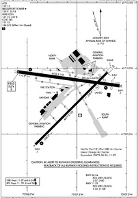
Runway 11/29
RWY 11/29 NOT AVBL FOR PART 121/PART 380 OPS WITH SKED PAX CARRYING OPS MORE THAN 9 PAX SEATS AND NON-SKED PAX CARRYING OPS MORE THAN 30 PAX SEATS. 90 DAY PPR FOR UNSKED ACR OPS GTR THAN 30 PAX SEATS - CALL AMGR. | ||
| Dimensions: | 4759 x 150 feet / 1451 x 46 meters | |
|---|---|---|
| Surface: | Asphalt in Fair Condition | |
| Weight Limits: | S-30, D-108
PCR VALUE: 278/F/B/X/U
| |
| Edge Lighting: | High Intensity | |
| Runway 11 | Runway 29 | |
| Coordinates: | N41°9.97' / W73°8.10' | N41°9.87' / W73°7.07' |
| Elevation: | 8.5 | 6.5 |
| Traffic Pattern: | Left | Right |
| Runway Heading: | 98° True | 278° True |
| Displaced Threshold: | 364 Feet | |
| Declared Distances: | TORA:4759 TODA:4759 ASDA:4759 LDA:4759 | TORA:4759 TODA:4759 ASDA:4759 LDA:4395 |
| Markings: | Basic in fair condition. | Non-Precision Instrument in fair condition. |
| Glide Slope Indicator | P4L (3.50° Glide Path Angle) | P4L (3.00° Glide Path Angle) |
| REIL: | Yes | Yes |
| Obstacles: | 35 ft Trees 500 ft from runway, 120 ft left of center | 15 ft Road 200 ft from runway APCH RATIO 20:1 TO DTHR. |
Runway 06/24
RWY 06/24 NOT AVBL FOR PART 121/PART 380 OPS WITH SKED PAX CARRYING OPS MORE THAN 9 PAX SEATS AND NON-SKED PAX CARRYING OPS MORE THAN 30 PAX SEATS. 90 DAY PPR FOR UNSKED ACR OPS GTR THAN 30 PAX SEATS - CALL AMGR. | ||
| Dimensions: | 4677 x 100 feet / 1426 x 30 meters | |
|---|---|---|
| Surface: | Asphalt / Grooved in Excellent Condition | |
| Weight Limits: | S-57, D-80
PCR VALUE: 278/F/B/X/U
| |
| Edge Lighting: | High Intensity | |
| Runway 06 | Runway 24 | |
| Coordinates: | N41°9.42' / W73°7.92' | N41°9.97' / W73°7.20' |
| Elevation: | 6.9 | 6.7 |
| Traffic Pattern: | Left | Left |
| Runway Heading: | 45° True | 225° True |
| Displaced Threshold: | 320 Feet | |
| Declared Distances: | TORA:4677 TODA:4677 ASDA:4677 LDA:4677 | TORA:4677 TODA:4677 ASDA:4677 LDA:4357 |
| Markings: | Precision Instrument in good condition. | Non-Precision Instrument in good condition. |
| Glide Slope Indicator | P4R (3.00° Glide Path Angle) | P4L (3.00° Glide Path Angle) |
| REIL: | Yes | Yes |
| Obstacles: | 19 ft Road 480 ft from runway, 525 ft left of center | 19 ft Road 200 ft from runway, 150 ft left of center APCH RATIO 34:1 TO DTHR. |
Services Available
| Fuel: | 100LL (blue), Jet-A |
|---|---|
| Transient Storage: | Hangars,Tiedowns |
| Airframe Repair: | MAJOR |
| Engine Repair: | MAJOR |
| Bottled Oxygen: | HIGH/LOW |
| Bulk Oxygen: | NOT AVAILABLE |
| Other Services: | AIR FREIGHT SERVICES,AIR AMBULANCE SERVICES,AVIONICS,CHARTER SERVICE,PILOT INSTRUCTION,AIRCRAFT RENTAL,AIRCRAFT SALES |
Ownership Information
| Ownership: | Publicly owned | |
|---|---|---|
| Owner: | CITY OF BRIDGEPORT | |
| 45 LYON TERRACE | ||
| BRIDGEPORT, CT 06615 | ||
| 203-576-7201 | ||
| Manager: | THOMAS NORKO | |
| 1000 GREAT MEADOW RD | ||
| STRATFORD, CT 06497 | ||
| 203-576-8163 | ||
Other Remarks
- THERE MAY BE STANDING WATER ADJ TO ALL SFCS.
- AVOID OVERFLYING RESL AREAS NE & SE OF ARPT. DEPARTING RWY 24 AVOID TURNS TIL 1/2 MILE BYD SHORELINE.
- WHEN ATCT CLSD ALL ENG RUNUPS ARE PROHIBITED. HWVR, IF AN ACFT RQRS NIGHTTIME ENG MAINT, PPR FM AMGR IS RQRD AND RUNUPS ARE TO BE PERFORMED ON TWY G BTWN J & K. PILOTS ARE ADZD TO USE CARE PSNG THEIR ACFT TO PREVENT DMG FM PROP WASH TO AFLD SIGN.
- UNEVEN SFCS RWY 29 SAFETY AREA APCH END LEFT SIDE.
- POLE 120 FT .75 NM S OF ARPT UNLGTD.
- RWY 29 CLSD TO TKOF ACFT MORE THAN 45000 LB EXC 30 MIN PPR 203-576-7497.
- FOR CD WHEN ATCT CLSD CTC NEW YORK APCH AT 516-683-2449 OR 124.075
- EXTSV HOP BLW 10000 FT 5-15 MI NW THRU NE, FOR TFC INFO WHEN INVOF ARPT CTC SIKORSKY OPS ON 133.6/305.8 (0700-1630).
- WHEN WINDS ARE LESS THAN 5 KTS RQSTD USE OF RWY 11 OR 29.
- BIRDS & WILDLIFE FQTLY ON & INVOF ARPT.
- WHEN ATCT CLSD, ACTVT REIL RWY 06 & 24, 11 & 29; PAPI RWY 06, 11 & 29; HIRL RWY 06/24 & 11/29 - CTAF.
- SNGL ENG ACFT 1000 FT AGL; ALL OTHERS 1500 FT AGL.
Weather Minimums
Standard Terminal Arrival (STAR) Charts
Instrument Approach Procedure (IAP) Charts
Departure Procedure (DP) Charts
Nearby Airports with Instrument Procedures
| ID | Name | Heading / Distance | ||
|---|---|---|---|---|
 |
KHVN | Tweed/New Haven Airport | 060° | 12.4 |
 |
KOXC | Waterbury-Oxford Airport | 358° | 18.9 |
 |
KDXR | Danbury Municipal Airport | 307° | 20.4 |
 |
KISP | Long Island Mac Arthur Airport | 176° | 22.1 |
 |
KHWV | Brookhaven Airport | 150° | 23.6 |
 |
KMMK | Meriden Markham Municipal Airport | 032° | 24.7 |
 |
KHPN | Westchester County Airport | 257° | 27.0 |
 |
KFRG | Republic Airport | 206° | 29.1 |
 |
KFOK | Francis S Gabreski Airport | 130° | 29.5 |
 |
KSNC | Chester Airport | 064° | 31.0 |
 |
4B8 | Robertson Field Airport | 020° | 33.7 |
 |
87N | Southampton Heliport | 122° | 35.5 |


