Login
Register


BMI
Central Il Regional/Bloomington-Normal Airport
Official FAA Data Effective 2025-11-27 0901Z
Chart Supplement

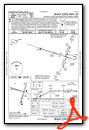
KBMI Airport Diagram

VFR Chart of KBMI
Sectional Charts at SkyVector.com
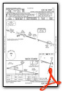
IFR Chart of KBMI
Enroute Charts at SkyVector.com
Location Information for KBMI
Coordinates: N40°28.63' / W88°54.96'Located 03 miles E of Bloomington/Normal, Illinois on 1968 acres of land. View all Airports in Illinois.
Surveyed Elevation is 871 feet MSL.
Operations Data
|
|
Airport Communications
| ATIS: | 119.575 |
|---|---|
| AWOS-3PT: | 135.35 Tel. 309-661-9478 |
| BLOOMINGTON TOWER: | 124.6 269.575 |
| BLOOMINGTON GROUND: | 121.65 |
| SAINT LOUIS APPROACH: | 128.725 256.9 |
| SAINT LOUIS DEPARTURE: | 128.725 256.9 |
| UNICOM: | 122.950 |
| CTAF: | 124.600 |
| EMERG: | 121.5 |
| AWOS-3 at AAA (27.1 SW): | 118.775 217-732-9605 |
| AWOS-3 at PNT (30.0 NE): | 119.675 815-844-0923 |
| AWOS-3 at TIP (37.1 E): | 119.025 217-892-4999 |
Nearby Navigation Aids
|
| ||||||||||||||||||||||||||||||||||||||||||||||||||||||||||||


Runway 02/20
| Dimensions: | 8000 x 150 feet / 2438 x 46 meters | |
|---|---|---|
| Surface: | Concrete / Grooved in Good Condition | |
| Weight Limits: | S-120, D-211, ST-322, DT-753
PCR VALUE: 700/R/D/W/T
| |
| Edge Lighting: | High Intensity | |
| Runway 02 | Runway 20 | |
| Coordinates: | N40°27.84' / W88°54.96' | N40°29.10' / W88°54.43' |
| Elevation: | 856.4 | 862.5 |
| Runway Heading: | 18° True | 198° True |
| Declared Distances: | TORA:8000 TODA:8000 ASDA:8000 LDA:8000 | TORA:8000 TODA:8000 ASDA:8000 LDA:8000 |
| Markings: | Precision Instrument in fair condition. | Precision Instrument in fair condition. |
| Glide Slope Indicator | P4R (3.00° Glide Path Angle) | |
| RVR Equipment | Touchdown Midfield Rollout | Touchdown Midfield Rollout |
| Approach Lights: | MALSR 1,400 Foot Medium-intensity Approach Lighting System with runway alignment indicator lights. | ALSF2 Standard 2,400 Foot High-intensity Approach Lighting System with sequenced flashers, CATEGORY II or III Configuration. WHEN ATCT CLSD ALSF2 OPR AS SSALR. |
| Centerline Lights: | Yes | Yes |
| Obstacles: | 40 ft Power Line 2007 ft from runway, 770 ft left of center | |
Runway 11/29
| Dimensions: | 6525 x 150 feet / 1989 x 46 meters SE END 565 FT CONC; RMNG 5960 FT ASPH. | |
|---|---|---|
| Surface: | Asphalt-Concrete / Grooved in Good Condition | |
| Weight Limits: | S-120, D-216, ST-349, DT-814
PCR VALUE: 700/R/C/W/T
| |
| Edge Lighting: | High Intensity | |
| Runway 11 | Runway 29 | |
| Coordinates: | N40°28.98' / W88°55.94' | N40°28.65' / W88°54.60' |
| Elevation: | 871.4 | 871.1 |
| Traffic Pattern: | Left | Left |
| Runway Heading: | 107° True | 287° True |
| Declared Distances: | TORA:6525 TODA:6525 ASDA:6525 LDA:6525 | TORA:6525 TODA:6525 ASDA:6525 LDA:6525 |
| Markings: | Precision Instrument in good condition. | Precision Instrument in good condition. |
| Glide Slope Indicator | V4R (3.00° Glide Path Angle) | |
| RVR Equipment | Rollout | Touchdown |
| Approach Lights: | MALSR 1,400 Foot Medium-intensity Approach Lighting System with runway alignment indicator lights. | |
Services Available
| Fuel: | 100LL (blue), Jet-A |
|---|---|
| Transient Storage: | Hangars,Tiedowns |
| Airframe Repair: | MAJOR |
| Engine Repair: | MAJOR |
| Bottled Oxygen: | LOW |
| Bulk Oxygen: | NOT AVAILABLE |
| Other Services: | AIR FREIGHT SERVICES,AIR AMBULANCE SERVICES,AVIONICS,CHARTER SERVICE,PILOT INSTRUCTION,AIRCRAFT RENTAL,AIRCRAFT SALES |
Ownership Information
| Ownership: | Publicly owned | |
|---|---|---|
| Owner: | CENTRAL ILLINOIS REGIONAL ARPT AUTH | |
| 3201 CIRA DRIVE | ||
| BLOOMINGTON, IL 61704 | ||
| 309-663-7383 | ||
| Manager: | CARL G. OLSON | |
| 3201 CIRA DRIVE | ||
| BLOOMINGTON, IL 61704 | ||
| 309-663-7383 | ||
Other Remarks
- BIRDS ON & INVOF ARPT.
- SNOW REMOVAL OPS WINTER MONTHS; WHEN ATCT CLSD MNT CTAF.
- WHEN ATCT CLSD LNDG/TKOF ANNOUNCE INTENTIONS ON CTAF.
- ARPT OPS H24 - 309-834-7396.
- ACTVT MALSR RWY 02 & 29; TDZ RWY 20; CNTLN 02/20; PAPI RWY 02; HIRL RWY 02/20 & 11/29 - CTAF. ALSF AVBL WHEN ATCT OPEN.
Weather Minimums
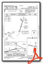
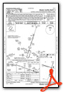
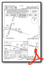
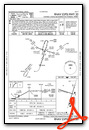
Instrument Approach Procedure (IAP) Charts

Nearby Airports with Instrument Procedures
| ID | Name | Heading / Distance | ||
|---|---|---|---|---|
 |
KAAA | Logan County Airport | 225° | 27.1 |
|
KPNT | Pontiac Municipal Airport | 026° | 29.9 |
|
C15 | Pekin Municipal Airport | 271° | 34.8 |
|
1C1 | Paxton Airport | 092° | 36.1 |
|
KTIP | Rantoul Ntl Avn Cntr-Frank Elliott Field Airport | 106° | 37.1 |
|
3MY | Mount Hawley Auxiliary Airport | 301° | 37.2 |
|
KPIA | General Downing - Peoria International Airport | 287° | 37.3 |
|
C16 | Frasca Field Airport | 120° | 38.4 |
|
KDEC | Decatur Airport | 176° | 38.6 |
|
C75 | Marshall County Airport | 326° | 38.9 |
|
KCMI | University of Illinois/Willard Airport | 131° | 39.4 |
|
KSPI | Abraham Lincoln Capital Airport | 222° | 51.6 |
Fuel Providers

Airport Images
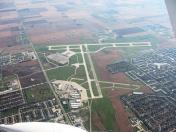
By: skiwoods


