Login
Register


ERV
Kerrville Municipal/Louis Schreiner Field Airport
Official FAA Data Effective 2026-01-22 0901Z
Chart Supplement

VFR Chart of KERV
Sectional Charts at SkyVector.com
IFR Chart of KERV
Enroute Charts at SkyVector.com
Location Information for KERV
Coordinates: N29°58.60' / W99°5.13'Located 05 miles SE of Kerrville, Texas on 528 acres of land. View all Airports in Texas.
Surveyed Elevation is 1616 feet MSL.
Operations Data
|
|
Airport Communications
| AWOS-3: | 118.125 Tel. 830-895-2204 |
|---|---|
| CTAF: | 122.700 |
| UNICOM: | 122.700 |
| AWOS-3 at T82 (18.4 NE): | 120.0 830-990-2716 |
| AWOS-3 at 5C1 (25.2 SE): | 118.725 830-755-9099 |
| AWOS-3T at U66 (34.1 SW): | 121.125 210-384-5834 |
- APCH/DEP CTL SVC PRVDD BY HOUSTON ARTCC (ZHU) ON FREQS 134.95/ 269.4 (KERRVILLE RCAG SITES).
- HOUSTON ARTCC PROVIDES CLEARANCE DELIVERY ON REMOTED FREQ 134.95.
Nearby Navigation Aids
|
| ||||||||||||||||||||||||||||||||||||||||||||||||||||||||||||


Runway 12/30
| Dimensions: | 6004 x 100 feet / 1830 x 30 meters | |
|---|---|---|
| Surface: | Asphalt in Good Condition | |
| Weight Limits: | 23 /F/C/W/T, S-22, D-73 | |
| Edge Lighting: | Medium Intensity | |
| Runway 12 | Runway 30 | |
| Coordinates: | N29°58.71' / W99°5.51' | N29°58.07' / W99°4.65' |
| Elevation: | 1573.4 | 1589.3 |
| Traffic Pattern: | Left | Left |
| Runway Heading: | 131° True | 311° True |
| Displaced Threshold: | 687 Feet | |
| Declared Distances: | TORA:6000 TODA:6000 ASDA:6000 LDA:5313 | TORA:6000 TODA:6000 ASDA:5300 LDA:5300 |
| Markings: | Non-Precision Instrument in fair condition. | Non-Precision Instrument in fair condition. |
| Glide Slope Indicator | P4L (3.00° Glide Path Angle) | P4L (3.00° Glide Path Angle) |
| REIL: | Yes | Yes |
Runway 03/21
| Dimensions: | 3597 x 58 feet / 1096 x 18 meters | |
|---|---|---|
| Surface: | Asphalt in Fair Condition | |
| Weight Limits: | S-15 | |
| Edge Lighting: | Medium Intensity | |
| Runway 03 | Runway 21 | |
| Coordinates: | N29°58.71' / W99°5.39' | N29°59.20' / W99°5.02' |
| Elevation: | 1573.8 | 1616.8 |
| Runway Heading: | 33° True | 213° True |
| Markings: | Basic in fair condition. | Basic in fair condition. |
| Glide Slope Indicator | P2L (3.50° Glide Path Angle) | P2L (3.50° Glide Path Angle) |
| Obstacles: | 40 ft Tree 940 ft from runway, 130 ft right of center | 50 ft Trees 960 ft from runway, 290 ft left of center |
Services Available
| Fuel: | 100LL (blue), Jet-A |
|---|---|
| Transient Storage: | Hangars,Tiedowns |
| Airframe Repair: | MAJOR |
| Engine Repair: | MAJOR |
| Bottled Oxygen: | HIGH |
| Bulk Oxygen: | NOT AVAILABLE |
| Other Services: | AVIONICS,PILOT INSTRUCTION,AIRCRAFT RENTAL,AIRCRAFT SALES |
Ownership Information
| Ownership: | Publicly owned | |
|---|---|---|
| Owner: | CITY OF KERRVILLE | AND KERR COUNTY JOINTLY |
| 1877 AIRPORT LOOP | ||
| KERRVILLE, TX 78028-5069 | ||
| 830-896-9399 | ||
| Manager: | MARY L ROHRER | |
| 1877 AIRPORT LOOP | ||
| KERRVILLE, TX 78028-5069 | ||
| 830-896-9399 | ||
Other Remarks
- DEER ON & INVOF ARPT.
- RWY 12 CALM WIND RWY.
- FOR CD CTC HOUSTON ARTCC AT 281-230-5622.
- DUSK-DAWN. MIRL RWYS 12/30 & 03/21 PRESET LOW INTST; TO INCR INTST AND ACTVT REIL RWYS 12 & 30 - CTAF.
Weather Minimums

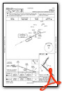
Instrument Approach Procedure (IAP) Charts


Nearby Airports with Instrument Procedures
| ID | Name | Heading / Distance | ||
|---|---|---|---|---|
 |
T82 | Gillespie County Airport | 029° | 18.4 |
|
5C1 | Boerne Stage Airfield Airport | 126° | 25.4 |
|
KHDO | South Texas Regional At Hondo Airport | 187° | 37.3 |
|
KCVB | Castroville Municipal Airport | 162° | 39.9 |
|
KSAT | San Antonio International Airport | 129° | 41.7 |
|
KSKF | Kelly Field Airport | 143° | 44.2 |
|
T92 | Mason County Airport | 353° | 45.5 |
|
KJCT | Kimble County Airport | 312° | 47.6 |
|
KRND | Randolph AFB Airport | 122° | 50.0 |
|
KSSF | Stinson Municipal Airport | 139° | 50.0 |
|
23R | Devine Municipal Airport | 171° | 50.7 |
|
KAQO | Llano Municipal Airport | 024° | 53.1 |


