Login
Register


GRB
Green Bay/Austin Straubel International Airport
Official FAA Data Effective 2026-02-19 0901Z
Chart Supplement

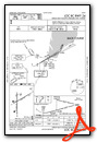
KGRB Airport Diagram

VFR Chart of KGRB
Sectional Charts at SkyVector.com
IFR Chart of KGRB
Enroute Charts at SkyVector.com
Location Information for KGRB
Coordinates: N44°29.08' / W88°7.78'Located 07 miles SW of Green Bay, Wisconsin on 2441 acres of land. View all Airports in Wisconsin.
Surveyed Elevation is 695 feet MSL.
Operations Data
|
|
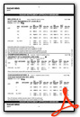
Airport Communications
| ATIS: | 124.1 |
|---|---|
| ASOS: | Tel. 920-204-7824 |
| GREEN BAY TOWER: | 118.7 257.8 |
| GREEN BAY GROUND: | 121.9 |
| GREEN BAY APPROACH: | 119.4 338.2 |
| GREEN BAY DEPARTURE: | 126.55 |
| CLEARANCE DELIVERY: | 121.75 |
| EMERG: | 121.5 243.0 |
| CLASS C: | 119.4 338.2 |
| CTAF: | 118.700 |
| AWOS-2 at 4WN7 (5.8 E): | |
| ATIS at ATW (21.5 SW): | 127.15 |
| AWOS-3 at ATW (22.0 SW): | 920-832-2597 |
- APCH/DEP SVC PRVDD BY MINNEAPOLIS ARTCC ON 133.175 (GREEN BAY RCAG)/317.7 (MOSINEE RCAG) WHEN GREEN BAY APCH CLSD.
Nearby Navigation Aids
|
| ||||||||||||||||||||||||||||||||||||||||||||||||||||||||||||


Runway 18/36
| Dimensions: | 8700 x 150 feet / 2652 x 46 meters | |
|---|---|---|
| Surface: | Concrete / Grooved in Good Condition | |
| Weight Limits: | S-120, D-170, ST-290
PCR VALUE: 520/R/B/W/T
| |
| Edge Lighting: | High Intensity | |
| Runway 18 | Runway 36 | |
| Coordinates: | N44°29.63' / W88°8.02' | N44°28.20' / W88°8.02' |
| Elevation: | 695.0 | 684.2 |
| Traffic Pattern: | Right | Left |
| Runway Heading: | 180° True | 360° True |
| Displaced Threshold: | 499 Feet | |
| Declared Distances: | TORA:8700 TODA:8700 ASDA:8700 LDA:8201 | TORA:8201 TODA:8201 ASDA:8201 LDA:8201 |
| Markings: | Precision Instrument in good condition. | Precision Instrument in good condition. |
| Glide Slope Indicator | P4R (3.00° Glide Path Angle) | P4L (3.00° Glide Path Angle) |
| RVR Equipment | Rollout | Touchdown |
| Approach Lights: | MALSR 1,400 Foot Medium-intensity Approach Lighting System with runway alignment indicator lights. | |
| REIL: | Yes | |
| Obstacles: | 12 ft Road 580 ft from runway, 540 ft left of center APCH RATIO 50:1 TO THE DTHR. |
|
Runway 06/24
| Dimensions: | 7700 x 150 feet / 2347 x 46 meters | |
|---|---|---|
| Surface: | Concrete / Grooved in Good Condition | |
| Weight Limits: | S-120, D-170, ST-290
PCR VALUE: 520/R/B/W/T
| |
| Edge Lighting: | High Intensity | |
| Runway 06 | Runway 24 | |
| Coordinates: | N44°28.95' / W88°8.28' | N44°29.58' / W88°6.75' |
| Elevation: | 692.0 | 681.6 |
| Traffic Pattern: | Left | Left |
| Runway Heading: | 60° True | 240° True |
| Declared Distances: | TORA:7699 TODA:7699 ASDA:7699 LDA:7699 | TORA:7699 TODA:7699 ASDA:7699 LDA:7699 |
| Markings: | Precision Instrument in good condition. | Precision Instrument in good condition. |
| Glide Slope Indicator | P4L (3.00° Glide Path Angle) | P4L (3.00° Glide Path Angle) |
| RVR Equipment | Touchdown | Rollout |
| Approach Lights: | MALSR 1,400 Foot Medium-intensity Approach Lighting System with runway alignment indicator lights. | |
Services Available
| Fuel: | 100LL (blue), Jet-A |
|---|---|
| Transient Storage: | Hangars,Tiedowns |
| Airframe Repair: | MAJOR |
| Engine Repair: | MAJOR |
| Bottled Oxygen: | HIGH |
| Bulk Oxygen: | HIGH |
Ownership Information
| Ownership: | Publicly owned | |
|---|---|---|
| Owner: | BROWN COUNTY | |
| 2077 AIRPORT DRIVE, STE #18 | ||
| GREEN BAY, WI 54313-5596 | ||
| 920-498-4800 | ||
| Manager: | MARTY PIETTE | |
| 2077 AIRPORT DRIVE | ||
| GREEN BAY, WI 54313-5596 | ||
| 920-498-4800 | ||
Other Remarks
- BIRDS ON & INVOF ARPT.
- TWY D BTN TWY H & RWY 24 APCH END CLSD TO WINGSPAN GTR THAN 118 FT.
- AVOID NOISE SENSITIVE AREAS N & E OF ARPT 2400-0600.
- TWY C NOT AVBL FOR ACR MORE THAN 30 PAX SEATS.
- TWY D WBND NO TURN ONTO TWY J.
- TWY J SWB NO TURN ONTO NBND TWY M.
- TWY M SBND NO TURN ONTO TWY J.
- TWY J SWB NO TURN ONTO EB TWY D.
- WHEN ATC CLSD FOR CD IF UNA TO CTC ON FSS FREQ, CTC MINNEAPOLIS ARTCC AT 651-463-5588.
- ACTVT MALSR RWY 06 & 36; REIL RWY 18; HIRL RWY 06/24 & 18/36 - CTAF. PAPI RWY 06, 18, 24 & 36 OPR CONSLY. WHEN ATCT CLSD PREFERRED RWY PRESET ON LOW OR MED INTST; INCR INTST - CTAF.
Weather Minimums


Instrument Approach Procedure (IAP) Charts


Nearby Airports with Instrument Procedures
| ID | Name | Heading / Distance | ||
|---|---|---|---|---|
 |
KATW | Appleton International Airport | 231° | 21.6 |
|
KOCQ | Oconto/J Douglas Bake Municipal Airport | 021° | 25.2 |
|
KEZS | Shawano Municipal Airport | 314° | 25.9 |
|
KCLI | Clintonville Municipal Airport | 286° | 26.9 |
|
KMTW | Manitowoc County Airport | 137° | 28.8 |
|
8D1 | New Holstein Municipal Airport | 178° | 32.4 |
|
KOSH | Wittman Regional Airport | 211° | 35.2 |
|
KSUE | Door County Cherryland Airport | 054° | 37.2 |
|
KPCZ | Waupaca Municipal Airport | 256° | 39.3 |
|
KMNM | Menominee Regional Airport | 028° | 43.9 |
|
KSBM | Sheboygan County Memorial International Airport | 164° | 44.5 |
|
KFLD | Fond Du Lac County Airport | 200° | 45.5 |
Fuel Providers


We proudly offer fuel from:

US Dollar per US Gallon
Price Guaranteed by FBO
Airport Images
Do you have a recent image of this airport? Upload it here!


