Login
Register


GVL
Lee Gilmer Memorial Airport
Official FAA Data Effective 2026-01-22 0901Z
Chart Supplement

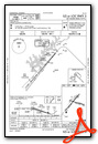
VFR Chart of KGVL
Sectional Charts at SkyVector.com
IFR Chart of KGVL
Enroute Charts at SkyVector.com
Location Information for KGVL
Coordinates: N34°16.36' / W83°49.81'Located 00 miles S of Gainesville, Georgia on 292 acres of land. View all Airports in Georgia.
Surveyed Elevation is 1276 feet MSL.
Operations Data
|
|
Airport Communications
| ASOS: | 126.475 Tel. 770-532-4687 |
|---|---|
| ATLANTA APPROACH: | 132.475 ;0615-2200 291.1 ;0615-2200 |
| ATLANTA DEPARTURE: | 132.475 ;0615-2200 291.1 ;0615-2200 |
| CTAF: | 123.075 |
| UNICOM: | 123.075 |
| AWOS-3PT at JCA (14.7 SE): | 118.125 706-387-6477 |
| AWOS-3PT at LZU (18.9 S): | 770-339-7753 |
| ATIS at LZU (18.9 S): | 132.275 |
- CD PRVDD BY ATLANTA ARTCC ON FREQS 134.8/307.9 (MOUNT OGLETHORPE RCAG) 2200-0615.
- APCH/DEP SVC PRVDD BY ATLANTA TRACON 0615-2200 ON FREQS 132.475/291.1 OTHER TIMES BY ATLANTA ARTCC ON FREQS 127.5/316.05 (ATHENS RCAG).
- CD PRVDD BY GAINESVILLE RCO ON FREQ 122.5 0615-2200.
Nearby Navigation Aids
|
| ||||||||||||||||||||||||||||||||||||||||||||||||||||||||||||


Runway 05/23
| Dimensions: | 5496 x 100 feet / 1675 x 30 meters | |
|---|---|---|
| Surface: | Asphalt / Grooved in Excellent Condition | |
| Weight Limits: | S-45, D-100 | |
| Edge Lighting: | High Intensity | |
| Runway 05 | Runway 23 | |
| Coordinates: | N34°16.02' / W83°50.28' | N34°16.71' / W83°49.56' |
| Elevation: | 1274.3 | 1237.5 |
| Traffic Pattern: | Left | Left |
| Runway Heading: | 41° True | 221° True |
| Displaced Threshold: | 396 Feet | |
| Declared Distances: | TORA:5496 TODA:5496 ASDA:5370 LDA:5370 | TORA:5496 TODA:5496 ASDA:5496 LDA:5100 |
| Markings: | Precision Instrument in good condition. | Precision Instrument in good condition. |
| Glide Slope Indicator | P4R (3.00° Glide Path Angle) | P4L (3.00° Glide Path Angle) |
| Approach Lights: | MALSR 1,400 Foot Medium-intensity Approach Lighting System with runway alignment indicator lights. | |
| Obstacles: | 23 ft Trees 269 ft from runway, 493 ft left of center | 15 ft Trees 279 ft from runway, 479 ft left of center APCH 32:1 TO DSPLCD THLD. BLDG 360 FT LEFT 0 FT - 80 FT FROM EOR. |
Runway 11/29
| Dimensions: | 4003 x 100 feet / 1220 x 30 meters | |
|---|---|---|
| Surface: | Asphalt in Fair Condition | |
| Weight Limits: | S-20, D-35 | |
| Runway 11 | Runway 29 | |
| Coordinates: | N34°16.45' / W83°50.05' | N34°16.25' / W83°49.29' |
| Elevation: | 1272.8 | 1259.9 |
| Traffic Pattern: | Left | Left |
| Runway Heading: | 108° True | 288° True |
| Displaced Threshold: | 120 Feet | 111 Feet |
| Declared Distances: | TORA:4001 TODA:4001 ASDA:3881 LDA:3770 | TORA:4001 TODA:4001 ASDA:3890 LDA:3770 |
| Markings: | Basic in good condition. | Basic in good condition. |
| Obstacles: | 42 ft Trees 242 ft from runway, 111 ft left of center | 42 ft Trees 494 ft from runway, 149 ft right of center |
Services Available
| Fuel: | 100LL (blue), Jet A+ |
|---|---|
| Transient Storage: | Tiedowns |
| Airframe Repair: | MAJOR |
| Engine Repair: | MINOR |
| Bottled Oxygen: | NONE |
| Bulk Oxygen: | HIGH |
| Other Services: | CHARTER SERVICE,PILOT INSTRUCTION,AIRCRAFT RENTAL,AIRCRAFT SALES |
Ownership Information
| Ownership: | Publicly owned | |
|---|---|---|
| Owner: | CITY OF GAINESVILLE | |
| P.O. BOX 2496 | ||
| GAINESVILLE, GA 30501 | ||
| 770-535-6882 | ||
| Manager: | LISA POOLE | |
| PO BOX 2496 | ||
| GAINESVILLE, GA 30503-2496 | ||
| 770-535-6882 | ||
Other Remarks
- DEER ON & INVOF ALL RYS.
- FOR CD IF UNA TO CTC ON FSS FREQ, CTC ATLANTA APCH AT 678-364-6131, WHEN ATCT CLSD CTC ATLANTA ARTCC AT 770-210-7692.
- 0LL 24 HOUR SELF SERVICE FUEL WITH CREDIT CARD.
- DUSK-DAWN. ACTVT MALSR RWY 05; HIRL RWY 05/23 - CTAF.
Weather Minimums

Standard Terminal Arrival (STAR) Charts
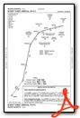
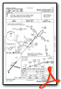
Instrument Approach Procedure (IAP) Charts

Nearby Airports with Instrument Procedures
| ID | Name | Heading / Distance | ||
|---|---|---|---|---|
 |
KJCA | Jackson County Airport | 113° | 14.6 |
|
KLZU | Gwinnett County/Briscoe Field Airport | 200° | 18.8 |
|
KWDR | Barrow County Airport | 154° | 19.2 |
|
KAJR | Habersham County Airport | 044° | 19.2 |
|
KCNI | Cherokee County Regional Airport | 274° | 29.5 |
|
D73 | Cy Nunnally Memorial Airport | 166° | 30.1 |
|
KAHN | Athens/Ben Epps Airport | 127° | 31.7 |
|
KTOC | Toccoa Rg Letourneau Field Airport | 053° | 32.7 |
|
KJZP | Pickens County Airport | 289° | 33.0 |
|
KPDK | Dekalb-Peachtree Airport | 224° | 33.4 |
|
18A | Franklin-Hart Airport | 083° | 35.0 |
|
KDZJ | Blairsville Airport | 346° | 35.8 |
Airport Images
Do you have a recent image of this airport? Upload it here!


Comments
A very busy airport and the
A very busy airport and the terminal is a museum. Someone came out to park me and fuel right away which is always nice. I needed to stay overnight with a rough engine that turned out to be a loose bottom spark plug otherwise would never stop here. The pilots are friendly and helpful but $15 to park on the grass with the fire ants is simple theft of a captive customer.