Login
Register


JYM
Hillsdale Municipal Airport
Official FAA Data Effective 2026-02-19 0901Z
Chart Supplement

VFR Chart of KJYM
Sectional Charts at SkyVector.com
IFR Chart of KJYM
Enroute Charts at SkyVector.com
Location Information for KJYM
Coordinates: N41°55.28' / W84°35.20'Located 02 miles E of Hillsdale, Michigan on 585 acres of land. View all Airports in Michigan.
Estimated Elevation is 1184 feet MSL.
Operations Data
|
|
Airport Communications
| AWOS-3P: | 121.025 Tel. 517-437-5638 |
|---|---|
| TOLEDO APPROACH: | 134.35 317.55 |
| TOLEDO DEPARTURE: | 134.35 317.55 |
| CTAF: | 122.800 |
| UNICOM: | 122.800 |
| AWOS-3P at OEB (20.9 W): | 118.125 517-279-1810 |
| ASOS at JXN (21.1 N): | 517-768-7506 |
| ATIS at JXN (21.1 N): | 125.725 |
Nearby Navigation Aids
|
| ||||||||||||||||||||||||||||||||||||||||||||||||||||||||||||


Runway 10/28
| Dimensions: | 5000 x 100 feet / 1524 x 30 meters | |
|---|---|---|
| Surface: | Asphalt / Grooved in Good Condition | |
| Weight Limits: | S-36, D-75 | |
| Edge Lighting: | High Intensity | |
| Runway 10 | Runway 28 | |
| Coordinates: | N41°55.30' / W84°35.75' | N41°55.25' / W84°34.65' |
| Elevation: | 1155.1 | 1184.2 |
| Traffic Pattern: | Left | Left |
| Runway Heading: | 94° True | 274° True |
| Markings: | Non-Precision Instrument in good condition. | Non-Precision Instrument in good condition. |
| Glide Slope Indicator | P4L (3.00° Glide Path Angle) | P4L (3.00° Glide Path Angle) |
| REIL: | Yes | Yes |
| Obstacles: | 14 ft Tree 553 ft from runway, 304 ft right of center | 9 ft Tree 403 ft from runway, 282 ft left of center |
Services Available
| Fuel: | 100LL (blue), Jet-A |
|---|---|
| Transient Storage: | Hangars,Tiedowns |
| Airframe Repair: | MAJOR |
| Engine Repair: | MAJOR |
| Bottled Oxygen: | NONE |
| Bulk Oxygen: | NONE |
| Other Services: | PILOT INSTRUCTION |
Ownership Information
| Ownership: | Publicly owned | |
|---|---|---|
| Owner: | CITY OF HILLSDALE | |
| 97 N BROAD ST | ||
| HILLSDALE, MI 49242-1617 | ||
| 517-437-6444 | ||
| Manager: | TRAVIS STEBELTON | |
| 1727 AIRPORT RD | ||
| HILLSDALE, MI 49242-0400 | ||
| 517-797-4833 | ||
Other Remarks
- DEER, LRG BIRDS, & WILDLIFE ON & INVOF ARPT.
- CTC AMGR FOR SNOW REMOVAL & ARPT CONDS.
- FOR CD CTC TOLEDO APCH AT 419-865-1495.
- 0LL 100LL AVBL H24 SELF SVC.
- JET A FUEL TRUCK AVBL FOR SNGL POINT FUELING WHEN ATNDD.
- ACTVT REIL RWY 10 & 28; PAPI RWY 10 & 28; HIRL RWY 10/28 - CTAF.
Weather Minimums

Instrument Approach Procedure (IAP) Charts

Nearby Airports with Instrument Procedures
| ID | Name | Heading / Distance | ||
|---|---|---|---|---|
 |
KOEB | Branch County Memorial Airport | 272° | 20.9 |
|
KJXN | Jackson County/Reynolds Field Airport | 015° | 21.1 |
|
KADG | Lenawee County Airport | 097° | 23.1 |
|
KRMY | Brooks Field Airport | 320° | 25.7 |
|
0G6 | Williams County Airport | 172° | 27.5 |
|
KUSE | Fulton County Airport | 132° | 27.8 |
|
KANQ | Tri-State Steuben County Airport | 233° | 28.0 |
|
KDFI | Defiance Memorial Airport | 168° | 35.7 |
|
KBTL | Battle Creek Exec At Kellogg Field Airport | 308° | 37.6 |
|
KIRS | Kirsch Municipal Airport | 260° | 38.8 |
|
KTEW | Mason Jewett Field Airport | 010° | 39.3 |
|
KTOL | Eugene F Kranz Toledo Express Airport | 119° | 40.3 |
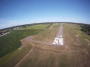
Airport Images

By: sunmanav8
By: David NaDell


