Login
Register


ANQ
Tri-State Steuben County Airport
Official FAA Data Effective 2026-02-19 0901Z
Chart Supplement

VFR Chart of KANQ
Sectional Charts at SkyVector.com
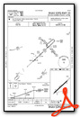
IFR Chart of KANQ
Enroute Charts at SkyVector.com
Location Information for KANQ
Coordinates: N41°38.38' / W85°5.01'Located 03 miles W of Angola, Indiana on 392 acres of land. View all Airports in Indiana.
Surveyed Elevation is 995 feet MSL.
Operations Data
|
|
Airport Communications
| AWOS-3: | 118.175 Tel. 260-668-5630 |
|---|---|
| FORT WAYNE APPROACH: | 127.2 ;SW/NW OF ACTIVE RWY 132.15 ;SE/NE OF ACTIVE RWY 284.6 |
| FORT WAYNE DEPARTURE: | 127.2 ;SW/NW OF ACTIVE RWY 132.15 ;SE/NE OF ACTIVE RWY 284.6 |
| UNICOM: | 123.075 |
| CTAF: | 123.075 |
| AWOS-3P at C62 (12.6 SW): | 119.925 260-347-2967 |
| AWOS-3P at OEB (17.5 N): | 118.125 517-279-1810 |
| AWOS-3P at IRS (19.1 NW): | 121.325 269-659-8715 |
Nearby Navigation Aids
|
| ||||||||||||||||||||||||||||||||||||||||||||||||||||||||||||


Runway 05/23
260 FT UNLGTD STWY SW END. | ||
| Dimensions: | 4540 x 75 feet / 1384 x 23 meters | |
|---|---|---|
| Surface: | Asphalt / Grooved in Excellent Condition | |
| Weight Limits: | S-4 | |
| Edge Lighting: | Medium Intensity | |
| Runway 05 | Runway 23 | |
| Coordinates: | N41°38.13' / W85°5.37' | N41°38.64' / W85°4.64' |
| Elevation: | 986.1 | 994.8 |
| Traffic Pattern: | Left | Left |
| Runway Heading: | 47° True | 227° True |
| Displaced Threshold: | 540 Feet | |
| Declared Distances: | TORA:4540 TODA:4540 ASDA:4540 LDA:4000 | TORA:4000 TODA:4000 ASDA:4000 LDA:4000 |
| Markings: | Non-Precision Instrument in good condition. | Non-Precision Instrument in fair condition. |
| Glide Slope Indicator | P2L (3.00° Glide Path Angle) | P2L (4.00° Glide Path Angle) |
| REIL: | Yes | Yes |
| Obstacles: | 15 ft Road 200 ft from runway, 205 ft right of center APCH SLOPE 34:1 FM DTHR. 15 FT ROAD 200 FT FM RWY END 205 FT R. |
73 ft Trees 860 ft from runway, 280 ft right of center |
Services Available
| Fuel: | 100LL (blue), Jet-A |
|---|---|
| Transient Storage: | Hangars,Tiedowns |
| Airframe Repair: | NOT AVAILABLE |
| Engine Repair: | NOT AVAILABLE |
| Bottled Oxygen: | NOT AVAILABLE |
| Bulk Oxygen: | NOT AVAILABLE |
| Other Services: | CROP DUSTING SERVICES,PARACHUTE JUMP ACTIVITY |
Ownership Information
| Ownership: | Publicly owned | |
|---|---|---|
| Owner: | STEUBEN CO BOAC | |
| 5220 W. U.S. 20 | ||
| ANGOLA, IN 46703-9680 | ||
| (260) 665-7111 | ||
| Manager: | AARON PAYONK | |
| 5220 W. U.S. 20 | ||
| ANGOLA, IN 46703-9680 | ||
| 260-316-3711 | ||
Other Remarks
- PAJA & BIRDS ON & INVOF ARPT; DEER SS-SR.
- COND UNMNT 1700-0800, WKEND & HOL.
- FOR CD CTC CHICAGO ARTCC AT 630-906-8921.
- ACTVT REIL RWY 05 & 23; MIRL RWY 05/23 - CTAF. DUSK-0000 MIRL RWY 05/23 PRESET LOW INTST; INCR INTST - CTAF.
Weather Minimums

Instrument Approach Procedure (IAP) Charts

Nearby Airports with Instrument Procedures
| ID | Name | Heading / Distance | ||
|---|---|---|---|---|
 |
C62 | Kendallville Municipal Airport | 218° | 12.8 |
|
KOEB | Branch County Memorial Airport | 004° | 17.7 |
|
KIRS | Kirsch Municipal Airport | 303° | 19.1 |
|
KGWB | Auburn/Dekalb Exec Airport | 177° | 20.0 |
|
0G6 | Williams County Airport | 111° | 28.0 |
|
KJYM | Hillsdale Municipal Airport | 052° | 28.0 |
|
KSMD | Smith Field Airport | 186° | 29.9 |
|
KGSH | Goshen Municipal Airport | 258° | 32.7 |
|
KDFI | Defiance Memorial Airport | 121° | 34.6 |
|
KRMY | Brooks Field Airport | 008° | 37.1 |
|
KFWA | Fort Wayne International Airport | 187° | 40.0 |
|
C03 | Nappanee Municipal Airport | 253° | 40.1 |
Airport Images
Do you have a recent image of this airport? Upload it here!


