Login
Register


OMH
Orange County Airport
Official FAA Data Effective 2026-01-22 0901Z
Chart Supplement

VFR Chart of KOMH
Sectional Charts at SkyVector.com
IFR Chart of KOMH
Enroute Charts at SkyVector.com
Location Information for KOMH
Coordinates: N38°14.83' / W78°2.74'Located 03 miles E of Orange, Virginia on 322 acres of land. View all Airports in Virginia.
Surveyed Elevation is 464 feet MSL.
Operations Data
|
|
Airport Communications
| AWOS-3: | 118.075 Tel. 540-672-0505 |
|---|---|
| POTOMAC APPROACH: | 120.525 132.85 323.125 |
| POTOMAC DEPARTURE: | 120.525 132.85 323.125 |
| UNICOM: | 122.800 |
| CTAF: | 122.800 |
| AWOS-3 at GVE (7.9 SW): | 120.225 540-832-2095 |
| AWOS-3 at LKU (14.8 S): | 119.475 540-967-1983 |
| AWOS-3 at CJR (18.9 NE): | 119.325 540-727-0523 |
Nearby Navigation Aids
|
| ||||||||||||||||||||||||||||||||||||||||||||||||||||||||||||


Runway 08/26
| Dimensions: | 3200 x 75 feet / 975 x 23 meters | |
|---|---|---|
| Surface: | Asphalt / Aggregate Friction Seal Coated in Good Condition | |
| Weight Limits: | S-12 | |
| Edge Lighting: | Medium Intensity | |
| Runway 08 | Runway 26 | |
| Coordinates: | N38°14.72' / W78°3.04' | N38°14.94' / W78°2.43' |
| Elevation: | 445.3 | 464.4 |
| Traffic Pattern: | Left | Left |
| Runway Heading: | 66° True | 246° True |
| Markings: | Non-Precision Instrument in good condition. | Non-Precision Instrument in good condition. |
| Glide Slope Indicator | P2L (4.00° Glide Path Angle) | P2L (4.00° Glide Path Angle) |
| REIL: | Yes | Yes |
| Obstacles: | 103 ft Tree 2389 ft from runway, 374 ft left of center | 60 ft Pole 1185 ft from runway, 381 ft left of center |
Services Available
| Fuel: | 100LL (blue), Jet A+ |
|---|---|
| Transient Storage: | Tiedowns |
| Airframe Repair: | NONE |
| Engine Repair: | NONE |
| Bottled Oxygen: | NONE |
| Bulk Oxygen: | NONE |
| Other Services: | PILOT INSTRUCTION,PARACHUTE JUMP ACTIVITY |
Ownership Information
| Ownership: | Publicly owned | |
|---|---|---|
| Owner: | ORANGE COUNTY | |
| P O BOX 111 | ||
| ORANGE, VA 22960 | ||
| 540-661-5400 | ||
| Manager: | PAUL J. WEBER | |
| 11275 AVIATION WAY | ||
| ORANGE, VA 22960 | ||
| 540-672-2158 | MOBILE 540-406-1821 | |
Other Remarks
- FOR CD CTC POTOMAC APCH AT 866-640-4124.
- PARACHUTE OPS.
- 0LL 100LL SELF SERVICE AFTER HOURS.
- JET-A+ SELF SERVICE AFTER HOURS.
- ACTVT REIL RWY 08 & 26; PAPI RWY 08 & 26; MIRL RWY 08/26 - CTAF.
Weather Minimums

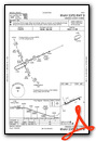
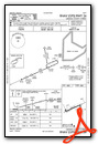
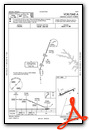
Instrument Approach Procedure (IAP) Charts
Nearby Airports with Instrument Procedures
| ID | Name | Heading / Distance | ||
|---|---|---|---|---|
 |
KGVE | Gordonsville Municipal Airport | 226° | 7.9 |
|
KLKU | Louisa County/Freeman Field Airport | 165° | 14.7 |
|
KCJR | Culpeper Regional Airport | 027° | 18.8 |
|
KCHO | Charlottesville-Albemarle Airport | 251° | 20.3 |
|
7W4 | Lake Anna Airport | 139° | 22.0 |
|
KHWY | Warrenton/Fauquier Airport | 037° | 25.7 |
|
KEZF | Shannon Airport | 087° | 28.2 |
|
KRMN | Stafford Regional Airport | 071° | 29.3 |
|
KLUA | Luray Caverns Airport | 319° | 33.1 |
|
KHEF | Manassas Regional/Harry P Davis Field Airport | 041° | 37.8 |
|
KNYG | Quantico Mcaf (Turner Field) Airport | 066° | 38.2 |
|
8W2 | New Market Airport | 308° | 39.7 |
Airport Images

By: Big Orange Bird

By: SkyFocal


