Login
Register


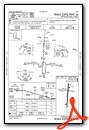
PQN
Pipestone Municipal Airport
Official FAA Data Effective 2026-02-19 0901Z
Chart Supplement

VFR Chart of KPQN
Sectional Charts at SkyVector.com
IFR Chart of KPQN
Enroute Charts at SkyVector.com
Location Information for KPQN
Coordinates: N43°58.93' / W96°18.02'Located 01 miles SE of Pipestone, Minnesota on 295 acres of land. View all Airports in Minnesota.
Surveyed Elevation is 1736 feet MSL.
Operations Data
|
|
Airport Communications
| AWOS-3PT: | 118.375 Tel. 507-825-6895 |
|---|---|
| UNICOM: | 122.800 |
| CTAF: | 122.800 |
| AWOS-3 at LYV (22.2 S): | 119.825 507-283-5027 |
| AWOS-3 at DVP (22.4 E): | 118.55 507-836-6128 |
| AWOS-3PT at BKX (29.5 NW): | 119.925 605-692-1809 |
- APCH/DEP SVC PRVDD BY MINNEAPOLIS ARTCC ON FREQS 132.050/317.4 (SIOUX FALLS RCAG).
Nearby Navigation Aids
|
| ||||||||||||||||||||||||||||||||||||||||||||||||||||||||||||


Runway 18/36
| Dimensions: | 4306 x 75 feet / 1312 x 23 meters | |
|---|---|---|
| Surface: | Asphalt in Good Condition | |
| Weight Limits: | S-16, D-22 | |
| Edge Lighting: | Medium Intensity | |
| Runway 18 | Runway 36 | |
| Coordinates: | N43°59.21' / W96°17.97' | N43°58.51' / W96°18.04' |
| Elevation: | 1736.0 | 1727.8 |
| Traffic Pattern: | Left | Left |
| Runway Heading: | 184° True | 4° True |
| Markings: | Non-Precision Instrument in good condition. | Non-Precision Instrument in good condition. |
| Glide Slope Indicator | P4L (3.00° Glide Path Angle) | P4L (3.00° Glide Path Angle) |
| REIL: | Yes | Yes |
| Obstacles: | 13 ft Brush 412 ft from runway, 145 ft right of center | |
Runway 09/27
NOT PLOWED WINTER MONTHS. | ||
| Dimensions: | 2539 x 196 feet / 774 x 60 meters | |
|---|---|---|
| Surface: | Turf in Good Condition | |
| Runway 09 | Runway 27 | |
| Coordinates: | N43°59.07' / W96°18.34' | N43°59.02' / W96°17.77' |
| Elevation: | 1723.7 | 1736.6 |
| Traffic Pattern: | Left | Left |
| Runway Heading: | 97° True | 277° True |
| Obstacles: | 10 ft Crops 22 ft from runway | |
Services Available
| Fuel: | 100LL (blue), Jet-A |
|---|---|
| Transient Storage: | Hangars,Tiedowns FOR HNGR CALL AMGR OR OWNER. |
| Airframe Repair: | NONE |
| Engine Repair: | NONE |
| Bottled Oxygen: | NONE |
| Bulk Oxygen: | NONE |
| Other Services: | CROP DUSTING SERVICES,AIRCRAFT SALES |
Ownership Information
| Ownership: | Publicly owned | |
|---|---|---|
| Owner: | CITY OF PIPESTONE | |
| 119 2ND AVE SW | ||
| PIPESTONE, MN 56164-1683 | ||
| 507-562-2332 | ||
| Manager: | ROBERT DYKSTRA | RDYKS@AOL.COM. |
| 1302 13TH ST SE | ||
| PIPESTONE, MN 56164-2294 | ||
| 605-360-2233 | ||
Other Remarks
- GCO AVBL ON FREQ 121.725 THRU MINNEAPOLIS ARTCC & FLT SVCS.
- FOR CD IF UNA VIA GCO CTC MINNEAPOLIS ARTCC AT 651-463-5588.
- YELLOW CONES.
- YELLOW CONES.
- 0LL FUEL AVBL H24 VIA CREDIT CARD.
- ACTVT REIL RWY 18 & 36; PAPI RWY 18 & 36; MIRL RWY 18/36 - CTAF.
Weather Minimums


Instrument Approach Procedure (IAP) Charts

Nearby Airports with Instrument Procedures
| ID | Name | Heading / Distance | ||
|---|---|---|---|---|
 |
KLYV | Quentin Aanenson Field Airport | 170° | 22.2 |
|
KDVP | Slayton Municipal Airport | 089° | 22.4 |
|
KBKX | Brookings Regional Airport | 310° | 29.6 |
|
KFSD | Joe Foss Field Airport | 218° | 30.7 |
|
KRRQ | Rock Rapids Municipal Airport | 170° | 32.2 |
|
KTKC | Tracy Municipal Airport | 061° | 34.0 |
|
KMDS | Madison Municipal Airport | 273° | 34.1 |
|
KMML | Southwest Minnesota Regional Marshall/Ryan Field Airport | 035° | 34.9 |
|
KOTG | Worthington Municipal Airport | 121° | 37.0 |
|
KISB | Sibley Municipal Airport | 147° | 43.7 |
|
KCNB | Myers Field Airport | 001° | 44.9 |
|
KSHL | Sheldon Regional Airport | 156° | 50.7 |
Airport Images

By: Bandco
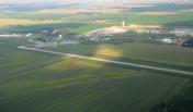
By: dontin


