Login
Register


SAZ
Staples Municipal Airport
Official FAA Data Effective 2026-02-19 0901Z
Chart Supplement

VFR Chart of KSAZ
Sectional Charts at SkyVector.com
IFR Chart of KSAZ
Enroute Charts at SkyVector.com
Location Information for KSAZ
Coordinates: N46°22.85' / W94°48.40'Located 02 miles NW of Staples, Minnesota on 172 acres of land. View all Airports in Minnesota.
Surveyed Elevation is 1287 feet MSL.
Operations Data
|
|
Airport Communications
| AWOS-3: | 118.325 Tel. 218-894-3666 |
|---|---|
| CTAF: | 122.900 |
| AWOS-3PT at ADC (17.2 W): | 118.875 218-631-7774 |
| AWOS-3 at RYM (25.5 SE): | 121.575 |
| AWOS-3PT at PWC (27.1 NE): | 118.525 218-587-3420 |
- APCH/DEP SVC PRVDD BY MINNEAPOLIS ARTCC ON FREQS 118.05/239.0 (BRAINERD RCAG).
Nearby Navigation Aids
|
| ||||||||||||||||||||||||||||||||||||||||||||||||||||||


Runway 14/32
| Dimensions: | 3305 x 75 feet / 1007 x 23 meters | |
|---|---|---|
| Surface: | Asphalt in Good Condition | |
| Edge Lighting: | Medium Intensity | |
| Runway 14 | Runway 32 | |
| Coordinates: | N46°23.08' / W94°48.62' | N46°22.63' / W94°48.17' |
| Elevation: | 1287.5 | 1284.6 |
| Traffic Pattern: | Left | Left |
| Runway Heading: | 145° True | 325° True |
| Markings: | Non-Precision Instrument in good condition. | Non-Precision Instrument in good condition. |
| Glide Slope Indicator | P4L (3.00° Glide Path Angle) | P4L (3.00° Glide Path Angle) |
| REIL: | Yes | Yes |
| Obstacles: | 24 ft Tree 285 ft from runway, 261 ft right of center 7 FT BRUSH, 45 FT DIST, 189 FT R. |
53 ft Tree 1137 ft from runway, 291 ft right of center |
Services Available
| Fuel: | 100LL (blue) |
|---|---|
| Transient Storage: | Tiedowns |
| Airframe Repair: | NONE |
| Engine Repair: | NONE |
| Bottled Oxygen: | NONE |
| Bulk Oxygen: | NONE |
| Other Services: | CROP DUSTING SERVICES,PILOT INSTRUCTION,AIRCRAFT RENTAL,AIRCRAFT SALES |
Ownership Information
| Ownership: | Publicly owned | |
|---|---|---|
| Owner: | CITY OF STAPLES | |
| 122 6TH ST NE | ||
| STAPLES, MN 56479-2900 | ||
| 218-894-2550 | ||
| Manager: | JEREL NELSEN | |
| 122 6TH ST NE | ||
| STAPLES, MN 56479-2900 | ||
| 218-894-2550 | ||
Other Remarks
- GCO AVBL ON FREQ 121.725 THRU MINNEAPOLIS ARTCC & FLT SVCS.
- ULTRALIGHT TFC ON & INVOF ARPT.
- FOR CD IF UNA VIA GCO CTC MINNEAPOLIS ARTCC AT 651-463-5588.
- 0LL FUEL AVBL H24 SELF SVC VIA CREDIT CARD.
- ACTVT REIL RWY 14 & 32; PAPI RWY 14 & 32; MIRL RWY 14/32 - CTAF.
Weather Minimums


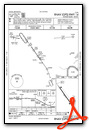
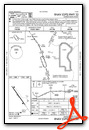
Instrument Approach Procedure (IAP) Charts
Nearby Airports with Instrument Procedures
| ID | Name | Heading / Distance | ||
|---|---|---|---|---|
 |
KADC | Wadena Municipal Airport | 284° | 17.3 |
|
KRYM | Ray S Miller AAF Airport | 132° | 25.5 |
|
KPWC | Pine River Regional Airport | 040° | 27.1 |
|
KBRD | Brainerd Lakes Regional Airport | 086° | 28.0 |
|
14Y | Todd Field Airport | 185° | 29.1 |
|
KLXL | Little Falls/Morrison County-Lindbergh Field Airport | 143° | 32.2 |
|
KPKD | Park Rapids Municipal/Konshok Field Airport | 340° | 33.1 |
|
16D | Perham Municipal Airport | 292° | 35.9 |
|
KAXN | Alexandria Regional/Chandler Field Airport | 218° | 39.4 |
|
D39 | Sauk Centre Municipal Airport | 187° | 40.8 |
|
KXVG | Longville Municipal Airport | 034° | 44.2 |
|
Y49 | Walker Municipal Airport | 008° | 47.2 |
Airport Images
Do you have a recent image of this airport? Upload it here!


