Login
Register


SER
Freeman Municipal Airport
Official FAA Data Effective 2026-01-22 0901Z
Chart Supplement

VFR Chart of KSER
Sectional Charts at SkyVector.com
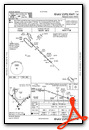
IFR Chart of KSER
Enroute Charts at SkyVector.com
Location Information for KSER
Coordinates: N38°55.46' / W85°54.58'Located 02 miles SW of Seymour, Indiana on 2100 acres of land. View all Airports in Indiana.
Surveyed Elevation is 582 feet MSL.
Operations Data
|
|
Airport Communications
| AWOS-3: | 119.425 Tel. 812-522-4244 |
|---|---|
| LOUISVILLE APPROACH: | 132.075 327.0 |
| LOUISVILLE DEPARTURE: | 132.075 327.0 |
| CTAF: | 122.800 |
| UNICOM: | 122.800 |
| AWOS-3 at OVO (16.0 NE): | 120.625 812-346-5041 |
| AWOS-3 at BAK (20.6 N): | 119.75 812-376-7584 |
| AWOS-3 at IMS (23.0 SE): | 119.175 812-866-1798 |
Nearby Navigation Aids
|
| ||||||||||||||||||||||||||||||||||||||||||||||||||||||||||||


Runway 05/23
| Dimensions: | 6001 x 100 feet / 1829 x 30 meters | |
|---|---|---|
| Surface: | Asphalt / Grooved in Good Condition | |
| Weight Limits: | S-115, D-180, ST-300 | |
| Edge Lighting: | Medium Intensity | |
| Runway 05 | Runway 23 | |
| Coordinates: | N38°54.92' / W85°54.66' | N38°55.63' / W85°53.78' |
| Elevation: | 568.3 | 577.7 |
| Runway Heading: | 44° True | 224° True |
| Markings: | Non-Precision Instrument in good condition. | Non-Precision Instrument in good condition. |
| Glide Slope Indicator | P2L (3.00° Glide Path Angle) | P2L (3.00° Glide Path Angle) |
| Approach Lights: | ODALS Omnidirectional Approach Lighting System | ODALS Omnidirectional Approach Lighting System |
| REIL: | Yes | Yes |
Runway 14/32
| Dimensions: | 5502 x 100 feet / 1677 x 30 meters | |
|---|---|---|
| Surface: | Asphalt / Grooved in Good Condition | |
| Weight Limits: | S-20, D-35, ST-50 | |
| Edge Lighting: | Medium Intensity | |
| Runway 14 | Runway 32 | |
| Coordinates: | N38°55.72' / W85°55.26' | N38°55.09' / W85°54.42' |
| Elevation: | 582.7 | 570.3 |
| Runway Heading: | 134° True | 314° True |
| Markings: | Non-Precision Instrument in good condition. | Non-Precision Instrument in good condition. |
| Glide Slope Indicator | P2L (3.00° Glide Path Angle) | P2L (3.00° Glide Path Angle) |
| REIL: | Yes | Yes |
| Obstacles: | 10 ft Crops 440 ft from runway | |
Runway 18U/36U
| Dimensions: | 1215 x 100 feet / 370 x 30 meters | |
|---|---|---|
| Surface: | Turf in Fair Condition | |
| Runway 18U | Runway 36U | |
| Coordinates: | N38°56.09' / W85°54.94' | N38°55.89' / W85°54.93' |
| Elevation: | 569.5 | 573.1 |
| Traffic Pattern: | Right | |
| Runway Heading: | 180° True | 0 |
Runway 09U/27U
| Dimensions: | 1104 x 100 feet / 336 x 30 meters | |
|---|---|---|
| Surface: | Turf in Good Condition | |
| Runway 09U | Runway 27U | |
| Coordinates: | N38°56.11' / W85°54.98' | N38°56.11' / W85°54.75' |
| Elevation: | 569.3 | 565.4 |
| Runway Heading: | 90° True | 270° True |
Services Available
| Fuel: | 100LL (blue), Jet A-1+ |
|---|---|
| Transient Storage: | Hangars,Tiedowns |
| Airframe Repair: | MINOR |
| Engine Repair: | MINOR |
| Bottled Oxygen: | LOW |
| Bulk Oxygen: | NOT AVAILABLE |
| Other Services: | AIR FREIGHT SERVICES,CROP DUSTING SERVICES,AIR AMBULANCE SERVICES,CARGO HANDLING SERVICES,GLIDER SERVICE,PILOT INSTRUCTION,AIRCRAFT RENTAL,ANNUAL SURVEYING |
Ownership Information
| Ownership: | Publicly owned | |
|---|---|---|
| Owner: | SEYMOUR AIRPORT AUTHORITY | |
| P.O. BOX 702 | ||
| SEYMOUR, IN 47274 | ||
| 812-522-2031 | ||
| Manager: | COLIN SMITH | |
| 1025 A AVENUE, PO BOX 702 | ||
| SEYMOUR, IN 47274 | ||
| 812-522-2031 | ||
Other Remarks
- RDO CTL ACFT OPS ON & INVOF ARPT DLY FM APR - OCT.
- TWY LGTS FM INT 14/32 & 05/23 TO APRON ONLY.
- FOR CD CTC LOUISVILLE APCH AT 502-375-7499.
- 0LL SELF SERVE AVBL 24 HR.
- ACTVT ODALS RWY 05 & 23; REIL RWY 05, 14, 23 & 32; PAPI RWY 05, 14, 23 & 32 - CTAF. MIRL RWY 05/23 & 14/32 PRESET ON.
Weather Minimums

Instrument Approach Procedure (IAP) Charts


Nearby Airports with Instrument Procedures
| ID | Name | Heading / Distance | ||
|---|---|---|---|---|
 |
KOVO | North Vernon Airport | 062° | 16.0 |
|
KBAK | Columbus Municipal Airport | 001° | 20.3 |
|
KIMS | Madison Regional Airport | 115° | 23.1 |
|
KBFR | Virgil I Grissom Municipal Airport | 258° | 25.6 |
|
I34 | Greensburg Municipal Airport | 037° | 29.8 |
|
KJVY | Clark Regional Airport | 166° | 34.4 |
|
KBMG | Monroe County Airport | 292° | 35.6 |
|
KGEZ | Shelbyville Municipal Airport | 007° | 39.8 |
|
KFRH | French Lick Municipal Airport | 233° | 42.4 |
|
KHFY | Indy South Greenwood Airport | 348° | 43.0 |
|
KLOU | Bowman Field Airport | 164° | 43.3 |
|
KSDF | Louisville Muhammad Ali International Airport | 169° | 45.7 |
Airport Images

By: 2flaps


