Login
Register


SMQ
Somerset Airport
Official FAA Data Effective 2026-02-19 0901Z
Chart Supplement

VFR Chart of KSMQ
Sectional Charts at SkyVector.com
IFR Chart of KSMQ
Enroute Charts at SkyVector.com
Location Information for KSMQ
Coordinates: N40°37.56' / W74°40.20'Located 03 miles N of Somerville, New Jersey on 210 acres of land. View all Airports in New Jersey.
Surveyed Elevation is 106 feet MSL.
Operations Data
|
|
Airport Communications
| ASOS: | 120.6 Tel. 908-722-2139 |
|---|---|
| NEWARK APPROACH: | 132.8 379.9 |
| NEWARK DEPARTURE: | 132.8 379.9 |
| CTAF: | 123.000 |
| JAIKE STAR: | 132.8 379.9 |
| WILKES-BARRE STAR: | 127.6 379.9 |
| UNICOM: | 123.000 |
| MAZIE STAR: | 379.9 |
| AWOS-3 at N40 (14.8 W): | 121.725 |
| ATIS at MMU (15.6 NE): | 124.25 |
| AWOS-3 at MMU (16.0 NE): | 973-290-0135 |
Nearby Navigation Aids
|
| ||||||||||||||||||||||||||||||||||||||||||||||||||||||||||||


Runway 12/30
| Dimensions: | 2739 x 65 feet / 835 x 20 meters | |
|---|---|---|
| Surface: | Asphalt in Good Condition | |
| Edge Lighting: | Medium Intensity | |
| Runway 12 | Runway 30 | |
| Coordinates: | N40°37.61' / W74°40.52' | N40°37.47' / W74°39.96' |
| Elevation: | 83.9 | 102.1 |
| Traffic Pattern: | Left | Left |
| Runway Heading: | 109° True | 289° True |
| Displaced Threshold: | 200 Feet | |
| Markings: | Non-Precision Instrument in good condition. | Non-Precision Instrument in good condition. |
| Glide Slope Indicator | P2R (3.00° Glide Path Angle) | P2L (4.00° Glide Path Angle) |
| REIL: | Yes | Yes |
| Obstacles: | 55 ft Trees 587 ft from runway, 163 ft right of center | 65 ft Trees 795 ft from runway, 280 ft left of center APCH RATIO 15:1 TO DTHR. |
Runway 08/26
550 FT W END UNSUITABLE FOR TKOF OR LDG DUE TO UNEVEN SFC. | ||
| Dimensions: | 1923 x 100 feet / 586 x 30 meters | |
|---|---|---|
| Surface: | Turf in Fair Condition | |
| Runway 08 | Runway 26 | |
| Coordinates: | N40°37.58' / W74°40.31' | N40°37.69' / W74°39.92' |
| Elevation: | 95.0 | 102.9 |
| Traffic Pattern: | Left | Right |
| Runway Heading: | 69° True | 249° True |
| Markings: | None | None |
| Obstacles: | 51 ft Tree 200 ft from runway, 50 ft left of center | 45 ft Tree 10 ft from runway, 140 ft right of center |
Runway 17/35
| Dimensions: | 1700 x 150 feet / 518 x 46 meters | |
|---|---|---|
| Surface: | Turf in Good Condition | |
| Runway 17 | Runway 35 | |
| Coordinates: | N40°37.63' / W74°40.31' | N40°37.37' / W74°40.19' |
| Elevation: | 97.2 | 87.4 |
| Runway Heading: | 161° True | 341° True |
| Markings: | None | None |
| Obstacles: | 65 ft Trees 20 ft from runway, 120 ft right of center | 22 ft Trees 10 ft from runway, 90 ft left of center |
Services Available
| Fuel: | 100LL (blue), Jet-A |
|---|---|
| Transient Storage: | Hangars,Tiedowns |
| Airframe Repair: | MAJOR |
| Engine Repair: | MAJOR |
| Bottled Oxygen: | HIGH/LOW |
| Bulk Oxygen: | HIGH/LOW |
| Other Services: | AIR AMBULANCE SERVICES,AVIONICS,CHARTER SERVICE,PILOT INSTRUCTION,AIRCRAFT RENTAL,AIRCRAFT SALES |
Ownership Information
| Ownership: | Privately Owned | |
|---|---|---|
| Owner: | SOMERSET AIR SERVICE, INC | |
| PO BOX 1007 | ||
| BEDMINSTER, NJ 07921 | ||
| 908-722-2444 | ||
| Manager: | CHRIS WALKER, PRES. | |
| PO BOX 1007 | ||
| BEDMINSTER, NJ 07921 | ||
| 908-722-2444 | ||
Other Remarks
- FOR CD CTC NEWARK APCH AT 800-645-3206.
- DEER AND BIRDS ON AND INVOF ARPT
- NO TGL.
- ACTVT REIL RWY 12 & 30; PAPI RWY 12 & 30; MIRL RWY 12/30 - 118.325.
Weather Minimums


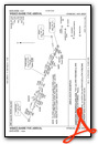
Standard Terminal Arrival (STAR) Charts


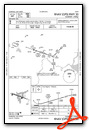
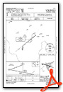
Instrument Approach Procedure (IAP) Charts

Nearby Airports with Instrument Procedures
| ID | Name | Heading / Distance | ||
|---|---|---|---|---|
 |
N51 | Solberg/Hunterdon Airport | 229° | 4.0 |
|
47N | Central Jersey Regional Airport | 151° | 6.9 |
|
39N | Princeton Airport | 177° | 13.6 |
|
N40 | Sky Manor Airport | 255° | 14.6 |
|
KMMU | Morristown Municipal Airport | 048° | 15.6 |
|
N85 | Alexandria Airport | 261° | 16.1 |
|
KLDJ | Linden Airport | 091° | 19.4 |
|
KTTN | Trenton Mercer Airport | 197° | 21.9 |
|
3N6 | Old Bridge Airport | 140° | 23.1 |
|
KCDW | Essex County Airport | 049° | 23.2 |
|
12N | Aeroflex/Andover Airport | 352° | 23.2 |
|
KEWR | Newark Liberty International Airport | 079° | 23.2 |
Airport Images
Do you have a recent image of this airport? Upload it here!


