Login
Register


39N
Princeton Airport
Official FAA Data Effective 2026-01-22 0901Z
Chart Supplement

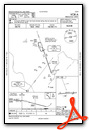
VFR Chart of 39N
Sectional Charts at SkyVector.com
IFR Chart of 39N
Enroute Charts at SkyVector.com
Location Information for 39N
Coordinates: N40°23.95' / W74°39.54'Located 03 miles N of Princeton/Rocky Hill, New Jersey on 100 acres of land. View all Airports in New Jersey.
Surveyed Elevation is 128 feet MSL.
Operations Data
|
|
Airport Communications
| NEWARK APPROACH: | 132.8 379.9 |
|---|---|
| NEWARK DEPARTURE: | 132.8 379.9 |
| CTAF: | 122.725 |
| UNICOM: | 122.725 |
| WILKES-BARRE STAR: | 127.6 379.9 |
| ATIS at TTN (10.2 SW): | 126.775 |
| ASOS at TTN (10.3 SW): | 126.775 609-538-8690 |
| ASOS at SMQ (13.5 N): | 120.6 908-722-2139 |
Nearby Navigation Aids
|
| ||||||||||||||||||||||||||||||||||||||||||||||||||||||||||||


Runway 10/28
| Dimensions: | 3499 x 75 feet / 1066 x 23 meters | |
|---|---|---|
| Surface: | Asphalt in Fair Condition NMRS TRANSVERSE CRACKS ALG ENTR LEN OF RWY. | |
| Weight Limits: | S-15 | |
| Edge Lighting: | Medium Intensity | |
| Runway 10 | Runway 28 | |
| Coordinates: | N40°23.94' / W74°39.92' | N40°23.95' / W74°39.16' |
| Elevation: | 120.0 | 128.0 |
| Traffic Pattern: | Left RY 10/28 RIGHT TFC HELICOPTERS. |
Left |
| Runway Heading: | 89° True | 269° True |
| Displaced Threshold: | 369 Feet | |
| Markings: | Non-Precision Instrument in good condition. | Non-Precision Instrument in good condition. |
| Glide Slope Indicator | P2L (3.45° Glide Path Angle) | P2L (3.00° Glide Path Angle) |
| REIL: | Yes | |
| Obstacles: | 44 ft Tree 1503 ft from runway, 124 ft right of center | 41 ft Building 528 ft from runway, 55 ft left of center RY 28 APCH SLOPE 21:1 TO DSPLCD THLD. |
Services Available
| Fuel: | 100LL (blue), Jet-A |
|---|---|
| Transient Storage: | Hangars,Tiedowns |
| Airframe Repair: | MAJOR |
| Engine Repair: | MAJOR |
| Bottled Oxygen: | NONE |
| Bulk Oxygen: | NONE |
| Other Services: | AVIONICS,CHARTER SERVICE,PILOT INSTRUCTION,AIRCRAFT RENTAL,AIRCRAFT SALES |
Ownership Information
| Ownership: | Privately Owned | |
|---|---|---|
| Owner: | PRINCETON AERO CORP | |
| PRINCETON ARPT 41 AIRPARK RD | ||
| PRINCETON, NJ 08540 | ||
| 609-921-3100 | ||
| Manager: | KENNETH NIERENBERG | |
| PRINCETON ARPT 41 AIRPARK RD | ||
| PRINCETON, NJ 08540 | ||
| 609-921-3100 | ||
Other Remarks
- RWY 28 DEPARTURE NO TURNS UNTIL AT LEAST 900 FT MSL AND BEYOND CHERRY HILL RD.
- DEER AND BIRDS ON AND INVOF ARPT.
- FOR CD CTC NEWARK APCH AT 800-645-3206
- ACTVT MIRL RY 10/28 AND REIL RWY 10 - 123.05.
Weather Minimums
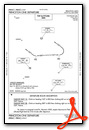
Standard Terminal Arrival (STAR) Charts
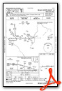
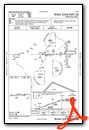
Instrument Approach Procedure (IAP) Charts
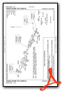
Departure Procedure (DP) Charts
Nearby Airports with Instrument Procedures
| ID | Name | Heading / Distance | ||
|---|---|---|---|---|
 |
47N | Central Jersey Regional Airport | 020° | 8.0 |
|
KTTN | Trenton Mercer Airport | 224° | 10.2 |
|
N87 | Trenton-Robbinsville Airport | 166° | 11.4 |
|
N51 | Solberg/Hunterdon Airport | 342° | 11.6 |
|
KSMQ | Somerset Airport | 357° | 13.6 |
|
3N6 | Old Bridge Airport | 106° | 14.9 |
|
N40 | Sky Manor Airport | 304° | 17.7 |
|
N85 | Alexandria Airport | 304° | 20.0 |
|
KDYL | Doylestown Airport | 259° | 21.6 |
|
KLDJ | Linden Airport | 055° | 23.0 |
|
KWRI | Mc Guire Field (Joint Base Mc Guire Dix Lakehurst) Airport | 172° | 23.2 |
|
KPNE | Northeast Philadelphia Airport | 220° | 25.0 |
Airport Images

By: Big Orange Bird

By: peterschiemann


