Login
Register


TNU
Newton Municipal-Earl Johnson Field Airport
Official FAA Data Effective 2026-01-22 0901Z
Chart Supplement

VFR Chart of KTNU
Sectional Charts at SkyVector.com
IFR Chart of KTNU
Enroute Charts at SkyVector.com
Location Information for KTNU
Coordinates: N41°40.47' / W93°1.30'Located 02 miles SE of Newton, Iowa on 304 acres of land. View all Airports in Iowa.
Surveyed Elevation is 952 feet MSL.
Operations Data
|
|
Airport Communications
| AWOS-3: | 132.275 Tel. 641-791-3302 |
|---|---|
| DES MOINES APPROACH: | 123.9 307.15 |
| DES MOINES DEPARTURE: | 123.9 307.15 |
| CLEARANCE DELIVERY: | 126.3 |
| CTAF: | 122.800 |
| UNICOM: | 122.800 |
| AWOS-3 at GGI (13.0 E): | 120.725 641-236-9720 |
| AWOS-3 at PEA (16.9 S): | 118.875 641-628-3459 |
| AWOS-3 at OXV (22.9 S): | 119.775 641-828-8406 |
Nearby Navigation Aids
|
| ||||||||||||||||||||||||||||||||||||||||||


Runway 14/32
| Dimensions: | 5600 x 100 feet / 1707 x 30 meters | |
|---|---|---|
| Surface: | Asphalt in Good Condition | |
| Weight Limits: | 32 /F/D/X/T, S-45, D-51 | |
| Edge Lighting: | Medium Intensity | |
| Runway 14 | Runway 32 | |
| Coordinates: | N41°40.83' / W93°1.69' | N41°40.11' / W93°0.92' |
| Elevation: | 952.4 | 945.5 |
| Traffic Pattern: | Left | Left |
| Runway Heading: | 141° True | 321° True |
| Markings: | Non-Precision Instrument in fair condition. | Precision Instrument in fair condition. |
| Glide Slope Indicator | V4L (3.00° Glide Path Angle) | V4L (3.00° Glide Path Angle) |
| Approach Lights: | MALSR 1,400 Foot Medium-intensity Approach Lighting System with runway alignment indicator lights. | |
| REIL: | Yes | |
| Obstacles: | 18 ft Road 860 ft from runway, 350 ft left of center | |
Services Available
| Fuel: | 100LL (blue), Jet-A |
|---|---|
| Transient Storage: | Hangars,Tiedowns |
| Airframe Repair: | MAJOR |
| Engine Repair: | MAJOR |
| Bottled Oxygen: | NONE |
| Bulk Oxygen: | NONE |
| Other Services: | CHARTER SERVICE,PILOT INSTRUCTION,AIRCRAFT RENTAL,AIRCRAFT SALES |
Ownership Information
| Ownership: | Publicly owned | |
|---|---|---|
| Owner: | CITY OF NEWTON | |
| 115 N. 2ND AVE E. PO BOX 399 | ||
| NEWTON, IA 50208 | ||
| 641-792-2787 | ||
| Manager: | ETHAN NASALROAD | |
| BOX 986-2901 RUSTY WALLACE DRIVE | ||
| NEWTON, IA 50208 | ||
| 641-792-1292 | ||
Other Remarks
- RY 14 IS CALM WIND RY.
- STADIUM WITHIN 3NM, CHECK FOR EVENTS.
- SEASONAL MIGRATORY WATERFOWL INVOF ARPT.
- FOR CD CTC DES MOINES ATCT ON 126.3 OR CALL 515-974-8016.
- ACTVT MIRL RY 14/32, VASI RYS 14 & 32, REIL RWY 14 AND MALSR RWY 32 - CTAF.
Weather Minimums


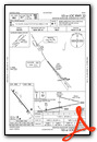
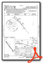
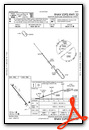
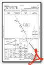
Instrument Approach Procedure (IAP) Charts
Nearby Airports with Instrument Procedures
| ID | Name | Heading / Distance | ||
|---|---|---|---|---|
 |
KGGI | Grinnell Regional Airport | 080° | 13.0 |
|
KPEA | Pella Municipal Airport | 168° | 16.7 |
|
KOXV | Knoxville Municipal Airport | 190° | 22.9 |
|
KIKV | Ankeny Regional Airport | 272° | 24.5 |
|
KMIW | Marshalltown Municipal Airport | 010° | 26.7 |
|
KDSM | Des Moines International Airport | 253° | 30.1 |
|
KAMW | Ames Municipal Airport | 305° | 33.0 |
|
KTZT | Belle Plaine Municipal Airport | 069° | 35.3 |
|
KOOA | Oskaloosa Municipal Airport | 138° | 35.9 |
|
KCNC | Chariton Municipal Airport | 201° | 42.1 |
|
4C8 | Albia Municipal Airport | 164° | 42.3 |
|
KOTM | Ottumwa Regional Airport | 142° | 42.8 |
Airport Images
Do you have a recent image of this airport? Upload it here!


