Login
Register


TQE
Tekamah Municipal Airport
Official FAA Data Effective 2026-01-22 0901Z
Chart Supplement

VFR Chart of KTQE
Sectional Charts at SkyVector.com
IFR Chart of KTQE
Enroute Charts at SkyVector.com
Location Information for KTQE
Coordinates: N41°45.81' / W96°10.68'Located 02 miles SE of Tekamah, Nebraska on 277 acres of land. View all Airports in Nebraska.
Surveyed Elevation is 1026 feet MSL.
Operations Data
|
|
Airport Communications
| ASOS: | 127.275 Tel. 402-374-2853 |
|---|---|
| OMAHA APPROACH: | 124.5 263.0 |
| OMAHA DEPARTURE: | 124.5 263.0 |
| UNICOM: | 123.000 |
| CTAF: | 123.000 |
| AWOS-3 at BTA (21.2 S): | 120.225 402-426-0448 |
| AWOS-3 at FET (24.3 SW): | 121.275 402-727-9135 |
| ASOS at OMA (29.8 SE): | 402-271-7515 |
Nearby Navigation Aids
|
| ||||||||||||||||||||||||||||||||||||||||||||||||||||||||||||


Runway 15/33
| Dimensions: | 4000 x 75 feet / 1219 x 23 meters | |
|---|---|---|
| Surface: | Concrete in Good Condition | |
| Weight Limits: | S-30, D-45 | |
| Edge Lighting: | Medium Intensity | |
| Runway 15 | Runway 33 | |
| Coordinates: | N41°46.11' / W96°10.87' | N41°45.52' / W96°10.48' |
| Elevation: | 1026.8 | 1023.9 |
| Traffic Pattern: | Left | Left |
| Runway Heading: | 154° True | 334° True |
| Markings: | Non-Precision Instrument in fair condition. | Non-Precision Instrument in good condition. |
| REIL: | Yes | |
| Obstacles: | UNLIGHTED CENTER PIVOT IRRIGATOR ROTATES THROUGH RWY 15 APPROACH DURING IRRIGATION SEASON |
15 ft Road 500 ft from runway, 295 ft right of center RWY 33 SML TREES 81 FT FM RWY END 194 FT RIGHT. |
Services Available
| Fuel: | 100LL (blue) |
|---|---|
| Transient Storage: | Hangars,Tiedowns |
| Airframe Repair: | MAJOR J&D AIRCRAFT SERVICE 402-374-1700. |
| Engine Repair: | MAJOR J&D AIRCRAFT SERVICE 402-374-1700. |
| Bottled Oxygen: | NONE |
| Bulk Oxygen: | NONE |
| Other Services: | CROP DUSTING SERVICES |
Ownership Information
| Ownership: | Publicly owned | |
|---|---|---|
| Owner: | TEKAMAH AIRPORT AUTHORITY | CHMN ARPT AUTH, CHARLES GOLL. |
| P.O.BOX 34 | ||
| TEKAMAH, NE 68061 | ||
| 402-838-9078 | ||
| Manager: | DOUG POLLOCK | |
| P.O. BOX 4 | ||
| TEKAMAH, NE 68061 | ||
| 402-374-1700 | ||
Other Remarks
- FOR SVC AFT HRS CALL 402-457-4373/402-870-0058.
- FOR CD CTC OMAHA APCH AT 402-682-4395.
- 0LL 100LL FUEL AVBL 24 HRS. SELF SVC.
- ACTVT RY 33 REIL - CTAF.
Weather Minimums

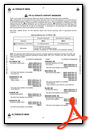
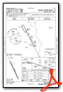
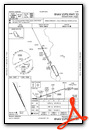
Instrument Approach Procedure (IAP) Charts
Nearby Airports with Instrument Procedures
| ID | Name | Heading / Distance | ||
|---|---|---|---|---|
 |
KBTA | Blair Exec Airport | 171° | 21.1 |
|
KSCB | Scribner State Airport | 245° | 22.3 |
|
KFET | Fremont Municipal Airport | 219° | 24.3 |
|
KMEY | James G Whiting Memorial Field Airport | 034° | 30.2 |
|
KOMA | Eppley Airfield Airport | 155° | 30.4 |
|
0C4 | Pender Municipal Airport | 310° | 32.4 |
|
KMLE | Millard Airport | 175° | 34.2 |
|
KCBF | Council Bluffs Municipal Airport | 147° | 35.6 |
|
KAHQ | Wahoo Municipal Airport | 211° | 36.6 |
|
KDNS | Denison Municipal Airport | 069° | 38.2 |
|
KHNR | Harlan Municipal Airport | 105° | 39.2 |
|
KSUX | Sioux Gateway/Brig General Bud Day Field Airport | 346° | 39.3 |
Airport Images
Do you have a recent image of this airport? Upload it here!


