Login
Register


YKN
Chan Gurney Municipal Airport
Official FAA Data Effective 2026-01-22 0901Z
Chart Supplement

VFR Chart of KYKN
Sectional Charts at SkyVector.com
IFR Chart of KYKN
Enroute Charts at SkyVector.com
Location Information for KYKN
Coordinates: N42°55.00' / W97°23.16'Located 03 miles N of Yankton, South Dakota on 458 acres of land. View all Airports in South Dakota.
Surveyed Elevation is 1305 feet MSL.
Operations Data
|
|
Airport Communications
| AWOS-3PT: | 119.05 Tel. 605-665-6072 |
|---|---|
| CTAF: | 122.800 |
| UNICOM: | 122.800 |
| AWOS-3P at VMR (21.9 SE): | 118.650 |
| AWOS-3P at AGZ (40.8 W): | 128.325 605-384-3922 |
| AWOS-3 at LCG (44.3 SE): | 120.125 402-375-0111 |
- APCH/DEP SVC PRVDD BY MINNEAPOLIS ARTCC ON FREQS 125.025/235.625 (SIOUX CITY RCAG).
Nearby Navigation Aids
|
| ||||||||||||||||||||||||||||||||||||||||||||||||||||||||||||


Runway 13/31
| Dimensions: | 6094 x 100 feet / 1857 x 30 meters | |
|---|---|---|
| Surface: | Concrete in Excellent Condition | |
| Weight Limits: | S-30, D-50, ST-90 | |
| Edge Lighting: | High Intensity | |
| Runway 13 | Runway 31 | |
| Coordinates: | N42°55.46' / W97°23.66' | N42°54.69' / W97°22.78' |
| Elevation: | 1305.9 | 1270.6 |
| Traffic Pattern: | Left | Left |
| Runway Heading: | 140° True | 320° True |
| Markings: | Precision Instrument in fair condition. | Precision Instrument in fair condition. |
| Glide Slope Indicator | V4L (3.00° Glide Path Angle) | V4L (3.00° Glide Path Angle) |
| Approach Lights: | MALSR 1,400 Foot Medium-intensity Approach Lighting System with runway alignment indicator lights. | |
| REIL: | Yes | |
Runway 02/20
| Dimensions: | 3380 x 60 feet / 1030 x 18 meters | |
|---|---|---|
| Surface: | Asphalt in Excellent Condition | |
| Weight Limits: | S-12 | |
| Edge Lighting: | Medium Intensity | |
| Runway 02 | Runway 20 | |
| Coordinates: | N42°54.61' / W97°23.18' | N42°55.13' / W97°22.90' |
| Elevation: | 1273.6 | 1281.7 |
| Traffic Pattern: | Left | Left |
| Runway Heading: | 21° True | 201° True |
| Markings: | Non-Precision Instrument in good condition. | Non-Precision Instrument in good condition. |
| Glide Slope Indicator | P2L (3.00° Glide Path Angle) | P2L (3.00° Glide Path Angle) |
| Obstacles: | 7 ft Power Line 385 ft from runway, 94 ft right of center | 6 ft Fence 382 ft from runway, 11 ft right of center |
Services Available
| Fuel: | 100LL (blue), Jet-A |
|---|---|
| Transient Storage: | Hangars,Tiedowns |
| Airframe Repair: | MAJOR |
| Engine Repair: | MAJOR |
| Bottled Oxygen: | NONE |
| Bulk Oxygen: | NONE |
| Other Services: | CROP DUSTING SERVICES,CHARTER SERVICE,PILOT INSTRUCTION,AIRCRAFT RENTAL,AIRCRAFT SALES |
Ownership Information
| Ownership: | Publicly owned | |
|---|---|---|
| Owner: | CITY OF YANKTON | |
| PO BOX 176 | ||
| YANKTON, SD 57078 | ||
| 605-668-5288 | ||
| Manager: | MIKE ROINSTAD | |
| 700 EAST 31ST STREET | ||
| YANKTON, SD 57078 | ||
| 605-661-9223 | ||
Other Remarks
- MIGRATORY WATERFOWL ON & INVOF ARPT.
- PAEW MOWING SEASONAL.
- FOR CD CTC MINNEAPOLIS ARTCC AT 651-463-5588.
- ACTVT MALSR RWY 31; REILS RWY 13; PAPI RWY 02 & 20; HIRL RWY 13/31; MIRL RWY 02/20 - CTAF.
Weather Minimums


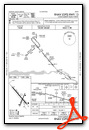
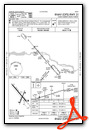
Instrument Approach Procedure (IAP) Charts

Nearby Airports with Instrument Procedures
| ID | Name | Heading / Distance | ||
|---|---|---|---|---|
 |
0B4 | Hartington Municipal/Bud Becker Field Airport | 162° | 19.7 |
|
KVMR | Harold Davidson Field Airport | 114° | 21.9 |
|
6K3 | Creighton Municipal Airport | 219° | 34.7 |
|
8V3 | Parkston Municipal Airport | 316° | 38.3 |
|
KAGZ | Wagner Municipal Airport | 282° | 41.1 |
|
KLCG | Wayne Municipal/Stan Morris Field Airport | 156° | 44.3 |
|
KFSD | Joe Foss Field Airport | 035° | 48.9 |
|
KLRJ | Le Mars Municipal Airport | 098° | 53.3 |
|
KSUX | Sioux Gateway/Brig General Bud Day Field Airport | 124° | 54.1 |
|
KSXK | Sioux County Regional Airport | 085° | 54.1 |
|
KOFK | Norfolk Regional/Karl Stefan Memorial Field Airport | 182° | 55.9 |
|
4V9 | Antelope County Airport | 211° | 56.3 |
Airport Images
Do you have a recent image of this airport? Upload it here!


