Login
Register


HLA
Huslia Airport
Official FAA Data Effective 2026-01-22 0901Z
Chart Supplement

VFR Chart of PAHL
Sectional Charts at SkyVector.com
IFR Chart of PAHL
Enroute Charts at SkyVector.com
Location Information for PAHL
Coordinates: N65°41.87' / W156°21.08'Located 01 miles E of Huslia, Alaska on 203 acres of land. View all Airports in Alaska.
Surveyed Elevation is 219 feet MSL.
Operations Data
|
|
Airport Communications
| AWOS-3P: | 135.75 Tel. 907-829-2282 |
|---|---|
| CTAF: | 122.800 |
| UNICOM: | 122.800 |
| AWOS-3P at GAL (59.4 S): | 132.525 907-656-2483 |
| AWOS-3P at RBY (62.2 S): | 118.25 907-468-4605 |
| AWOS-3P at NUL (72.5 SW): | 118.0 907-269-2774 |
- APCH/DEP SVC PRVDD BY ANCHORAGE ARTCC ON FREQS 127.0/290.2 (GALENA RCAG).
- COMMUNICATIONS PRVDD BY FAIRBANKS FSS ON FREQ 122.4 (HUSLIA RCO).
Nearby Navigation Aids
|
| ||||||||||||||||||||||||

Runway 03/21
| Dimensions: | 4000 x 75 feet / 1219 x 23 meters | |
|---|---|---|
| Surface: | Gravel in Good Condition RY SOFT WHEN WET. | |
| Edge Lighting: | Medium Intensity | |
| Runway 03 | Runway 21 | |
| Coordinates: | N65°41.67' / W156°21.70' | N65°42.08' / W156°20.46' |
| Elevation: | 219.7 | 208.6 |
| Runway Heading: | 51° True | 231° True |
| Glide Slope Indicator | P4L (3.00° Glide Path Angle) | P4L (3.00° Glide Path Angle) |
| REIL: | Yes | Yes |
| Obstacles: | 14 ft Tree 0 ft from runway, 187 ft left of center | 10 ft Trees 0 ft from runway, 145 ft right of center |
Services Available
| Fuel: | NONE |
|---|---|
| Transient Storage: | Tiedowns |
| Airframe Repair: | NOT AVAILABLE |
| Engine Repair: | NOT AVAILABLE |
| Bottled Oxygen: | NOT AVAILABLE |
| Bulk Oxygen: | NOT AVAILABLE |
Ownership Information
| Ownership: | Publicly owned | |
|---|---|---|
| Owner: | ALASKA DOT&PF NORTHERN REGION | |
| 2301 PEGER RD | ||
| FAIRBANKS, AK 99709-5399 | ||
| (907) 451-5280 | ||
| Manager: | JASON LUDINGTON | |
| 2301 PEGER RD | ||
| FAIRBANKS, AK 99709-5399 | ||
| (907) 451-5280 | ||
Other Remarks
- RY CONDITION UNMONITORED; RECOMMEND VISUAL INSPECTION PRIOR TO LDG.
- SNOW REMOVAL OPNS DURG WINTER. MONITOR CTAF.
- WX CAMERA AVBL ON INTERNET AT HTTPS://WEATHERCAMS.FAA.GOV
- ACTVT MIRL RY 03/21; PAPI & REIL RYS 03 & 21 - CTAF.
Weather Minimums

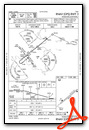
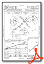
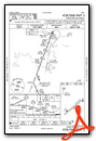
Instrument Approach Procedure (IAP) Charts
Nearby Airports with Instrument Procedures
| ID | Name | Heading / Distance | ||
|---|---|---|---|---|
 |
PAHU | Hughes Airport | 067° | 55.4 |
|
PAGA | Edward G Pitka Sr Airport | 194° | 59.7 |
|
PFKU | Koyukuk Airport | 215° | 60.5 |
|
PARY | Ruby Airport | 158° | 62.5 |
|
PANU | Nulato Airport | 217° | 72.8 |
|
PAGH | Shungnak Airport | 345° | 74.3 |
|
PAOB | Kobuk Airport | 349° | 74.3 |
|
PAFM | Ambler Airport | 337° | 92.2 |
|
PAKV | Kaltag Airport | 217° | 102.9 |
Airport Images
Do you have a recent image of this airport? Upload it here!


