Login
Register


SAF
Santa Fe Regional Airport
Official FAA Data Effective 2026-01-22 0901Z
Chart Supplement

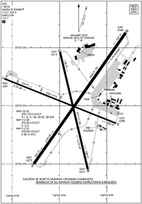
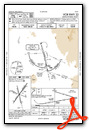
KSAF Airport Diagram
VFR Chart of KSAF
Sectional Charts at SkyVector.com
IFR Chart of KSAF
Enroute Charts at SkyVector.com
Location Information for KSAF
Coordinates: N35°37.03' / W106°5.37'Located 09 miles SW of Santa Fe, New Mexico on 2128 acres of land. View all Airports in New Mexico.
Surveyed Elevation is 6348 feet MSL.
R/W TFC PAT ALT 7000 FT MSL.
Operations Data
|
|
Airport Communications
| ATIS: | 128.55 |
|---|---|
| ASOS: | Tel. 505-474-3117 |
| SANTA FE TOWER: | 119.5 239.3 |
| SANTA FE GROUND: | 121.7 |
| UNICOM: | 122.950 |
| CTAF: | 119.500 |
| EMERG: | 121.5 243.0 |
| AWOS-3 at LAM (18.0 NW): | 124.175 505-662-8423 |
| AWOS-3 at 0E0 (38.3 S): | 118.05 505-832-9379 |
| ASOS at CQC (42.4 SE): | 575-472-4551 |
- APCH/DEP SVC PRVDD BY ALBUQUERQUE ARTCC (ZAB) ON FREQS 132.8/346.35 (SANDIA MOUNTAIN RCAG).
Nearby Navigation Aids
|
| ||||||||||||||||||||||||||||||||||||||||||


Runway 02/20
| Dimensions: | 8366 x 150 feet / 2550 x 46 meters | |
|---|---|---|
| Surface: | Asphalt / Porous Friction Course in Poor Condition | |
| Weight Limits: | S-116, D-164, ST-269
PCR VALUE: 170/F/D/X/T
| |
| Edge Lighting: | Medium Intensity MIDFIELD LGT COLORED. | |
| Runway 02 | Runway 20 | |
| Coordinates: | N35°36.50' / W106°5.77' | N35°37.63' / W106°4.80' |
| Elevation: | 6273.3 | 6348.0 |
| Traffic Pattern: | Left | Left |
| Runway Heading: | 35° True | 215° True |
| Markings: | Precision Instrument in good condition. | Precision Instrument in good condition. |
| Glide Slope Indicator | V4L (3.00° Glide Path Angle) | V4L (3.00° Glide Path Angle) |
| REIL: | Yes | |
| Obstacles: | 6 ft Hill 225 ft from runway, 226 ft left of center | |
Runway 15/33
| Dimensions: | 6316 x 100 feet / 1925 x 30 meters | |
|---|---|---|
| Surface: | Asphalt / Grooved in Excellent Condition | |
| Weight Limits: | S-28, D-43
PCR VALUE: 80/F/D/X/T
| |
| Edge Lighting: | Medium Intensity | |
| Runway 15 | Runway 33 | |
| Coordinates: | N35°37.47' / W106°5.49' | N35°36.45' / W106°5.20' |
| Elevation: | 6319.1 | 6272.9 |
| Traffic Pattern: | Left | Left |
| Runway Heading: | 167° True | 347° True |
| Declared Distances: | TORA:6316 TODA:6316 ASDA:5221 LDA:5221 | |
| Markings: | Non-Precision Instrument in good condition. | Non-Precision Instrument in good condition. |
| Glide Slope Indicator | V4R (3.00° Glide Path Angle) | |
| REIL: | Yes | Yes |
Runway 10/28
| Dimensions: | 6301 x 75 feet / 1921 x 23 meters | |
|---|---|---|
| Surface: | Asphalt / Porous Friction Course in Good Condition | |
| Weight Limits: | S-12
PCR VALUE: 80/F/D/X/T
| |
| Runway 10 | Runway 28 | |
| Coordinates: | N35°37.23' / W106°6.08' | N35°36.85' / W106°4.90' |
| Elevation: | 6281.2 | 6298.2 |
| Traffic Pattern: | Left | Left |
| Runway Heading: | 112° True | 292° True |
| Markings: | Non-Precision Instrument in good condition. | Non-Precision Instrument in good condition. |
| REIL: | Yes | |
| Obstacles: | 11 ft Road 250 ft from runway, 260 ft right of center | |
Helipad H1
| Dimensions: | 40 x 40 feet / 12 x 12 meters | |
|---|---|---|
| Surface: | Concrete | |
| Coordinates: | N35°36.93' / W106°4.88' | N0°0.00' / E0°0.00' |
| Elevation: | 6311.0 | |
Services Available
| Fuel: | 100LL (blue), Jet-A, Jet A+ |
|---|---|
| Transient Storage: | Hangars,Tiedowns |
| Airframe Repair: | MAJOR |
| Engine Repair: | MAJOR |
| Bottled Oxygen: | HIGH/LOW |
| Bulk Oxygen: | HIGH/LOW |
| Other Services: | AIR AMBULANCE SERVICES,AVIONICS,CHARTER SERVICE,PILOT INSTRUCTION,AIRCRAFT RENTAL,AIRCRAFT SALES,ANNUAL SURVEYING |
Ownership Information
| Ownership: | Publicly owned | |
|---|---|---|
| Owner: | CITY OF SANTA FE | |
| PO BOX 909 | ||
| SANTA FE, NM 87504-0909 | ||
| 505-955-2910 | ||
| Manager: | JIMMY GUNN | |
| 121 AVIATION DR | ||
| SANTA FE, NM 87507-0909 | ||
| 505-955-2910 | AMGR: 505-955-2910, 505-955-2903. | |
Other Remarks
- RNG ON FLD.
- NOISE ABATEMENT PROC - AMGR.
- FOR CD IF UNA TO CTC ON FSS FREQ, CTC ALBUQUERQUE ARTCC AT 505-856-4561.
- WHEN ATCT CLSD ACTVT MIRL RWY 02/20, 15/33 - CTAF; MIRL RWY 02/20 PRESET LOW INTST; INCR INTST - CTAF.
- R/W TFC PAT ALT 7000 FT MSL.
Weather Minimums

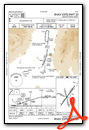
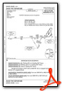
Instrument Approach Procedure (IAP) Charts


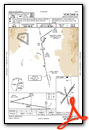
Departure Procedure (DP) Charts


Nearby Airports with Instrument Procedures
| ID | Name | Heading / Distance | ||
|---|---|---|---|---|
 |
KLAM | Los Alamos Airport | 330° | 18.0 |
|
0E0 | Moriarty Municipal Airport | 173° | 38.5 |
|
KABQ | Albuquerque International Sunport Airport | 216° | 43.0 |
|
KAEG | Double Eagle II Airport | 230° | 44.7 |
|
KLVS | Las Vegas Municipal Airport | 086° | 46.4 |
|
KSKX | Taos Regional Airport | 021° | 54.0 |
|
KAXX | Angel Fire Airport | 038° | 62.0 |
|
KBRG | Belen Regional Airport | 212° | 68.8 |
|
KGNT | Grants-Milan Municipal Airport | 253° | 92.9 |
|
KRTN | Raton Municipal/Crews Field Airport | 048° | 102.4 |
|
KONM | Socorro Municipal Airport | 203° | 103.6 |
|
KALS | San Luis Valley Regional/Bergman Field Airport | 005° | 109.5 |
Fuel Providers

Airport Images

By: pataylo


