Login
Register
VA58
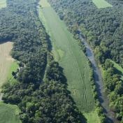
River Bend Airport
Official FAA Data Effective 2026-02-19 0901Z
VFR Chart of VA58
Sectional Charts at SkyVector.com
IFR Chart of VA58
Enroute Charts at SkyVector.com
Location Information for VA58
Coordinates: N38°54.37' / W78°26.67'Located 02 miles SE of Maurertown, Virginia on 10 acres of land. View all Airports in Virginia.
Estimated Elevation is 606 feet MSL.
Operations Data
|
|
Airport Communications
| CTAF: | 122.900 |
|---|---|
| AWOS-3 at FRR (9.2 E): | 121.85 540-635-5377 |
| AWOS-3 at LUA (14.6 S): | 118.275 540-743-1148 |
| AWOS-3 at 8W2 (19.4 SW): | 118.175 540-740-3801 |
Nearby Navigation Aids
|
| ||||||||||||||||||||||||||||||||||||||||||||||||||||||||||||
Runway 14/32
| Dimensions: | 2650 x 60 feet / 808 x 18 meters | |
|---|---|---|
| Surface: | Turf | |
| Runway 14 | Runway 32 | |
| Traffic Pattern: | Right | |
| Obstacles: | 50 ft Trees 1000 ft from runway | |
Ownership Information
| Ownership: | Privately Owned | |
|---|---|---|
| Owner: | RIVER BEND FIELD, LLC | |
| 6294 APPLE HARVEST DR | ||
| GERRARDSTOWN, WV 25420 | ||
| 240-888-6144 | ||
| Manager: | MAZDA EBRAHIMI | |
| 6294 APPLE HARVEST DR | ||
| GERRARDSTOWN, WV 25420 | ||
| 240-888-6144 | ||
Other Remarks
- AIRPORT IS TEMPORARILY CLOSED.
- FOR CD CTC WASHINGTON ARTCC AT 703-771-3587.
Nearby Airports with Instrument Procedures
| ID | Name | Heading / Distance | ||
|---|---|---|---|---|
 |
KFRR | Front Royal-Warren County Airport | 085° | 9.0 |
 |
KLUA | Luray Caverns Airport | 190° | 14.6 |
 |
8W2 | New Market Airport | 219° | 19.4 |
 |
KOKV | Winchester Regional Airport | 044° | 20.0 |
 |
W99 | Grant County Airport | 279° | 33.3 |
 |
KCJR | Culpeper Regional Airport | 129° | 35.7 |
 |
KMRB | Eastern Wv Regional/Shepherd Field Airport | 035° | 36.7 |
 |
KHWY | Warrenton/Fauquier Airport | 118° | 39.4 |
 |
KVBW | Bridgewater Air Park Airport | 216° | 40.4 |
 |
KJYO | Leesburg Exec Airport | 075° | 42.8 |
 |
KOMH | Orange County Airport | 154° | 43.7 |
 |
KSHD | Shenandoah Valley Regional Airport | 209° | 44.0 |


