Login
Register


W94
Camp Peary Lndg Strip Airport
Official FAA Data Effective 2026-02-19 0901Z
Chart Supplement

VFR Chart of W94
Sectional Charts at SkyVector.com
IFR Chart of W94
Enroute Charts at SkyVector.com
Location Information for W94
Coordinates: N37°18.77' / W76°38.29'Located 03 miles NE of Williamsburg, Virginia. View all Airports in Virginia.
Estimated Elevation is 40 feet MSL.
Operations Data
|
|
Airport Communications
| NORFOLK APPROACH: | 125.7 335.625 |
|---|---|
| NORFOLK DEPARTURE: | 125.7 335.625 |
| AWOS-3 at JGG (5.8 SW): | 120.625 757-220-8810 |
| ASOS at PHF (12.9 SE): | 757-874-3682 |
| ATIS at PHF (12.9 SE): | 128.65 |
- APCH/DEP SVC PRVDD BY ORF APCH ON 125.7/335.625.
Nearby Navigation Aids
|
| ||||||||||||||||||||||||||||||||||||||||||||||||||||||||||||


Runway 05/23
| Dimensions: | 5018 x 151 feet / 1529 x 46 meters FLD CLSD TO ALL CIV & MIL ACFT WO PRIOR APVL OF BASE COMDR. | |
|---|---|---|
| Surface: | Asphalt | |
| Edge Lighting: | Low Intensity | |
| Runway 05 | Runway 23 | |
| Coordinates: | N37°18.45' / W76°38.62' | N37°19.09' / W76°37.96' |
| Elevation: | 40.8 | 31.3 |
| Traffic Pattern: | Left | Left |
| Glide Slope Indicator | P4L | P4L |
| Approach Lights: | ALSF2 Standard 2,400 Foot High-intensity Approach Lighting System with sequenced flashers, CATEGORY II or III Configuration. | ALSF2 Standard 2,400 Foot High-intensity Approach Lighting System with sequenced flashers, CATEGORY II or III Configuration. |
Services Available
| Fuel: | NONE |
|---|---|
| Transient Storage: | NONE |
| Airframe Repair: | NONE |
| Engine Repair: | NONE |
| Bottled Oxygen: | NOT AVAILABLE |
| Bulk Oxygen: | NOT AVAILABLE |
Ownership Information
| Ownership: | Owned by the Army | |
|---|---|---|
| Owner: | US ARMY AERONAUTICAL SVCS AGENCY | |
| FT BELVOIR, VA 22060 | ||
| Manager: | DAVID J CROMLEY | COLONEL INFANTRY. |
| AFETA-CAMP PEARY | ||
| WILLIAMSBURG, VA 23185 | ||
| 757-808-3900 | SECOND MGR NUMBER 757-808-3901 | |
Other Remarks
- CAUTION: FLD RSTD, PPR BY WRITTEN REQ TO BASE COMDR, ATTN: AIR OPS. EXC WHEN OPR UNDER PRIOR PERMS AUTH, PILOTS SHOULD MAINT AT LEAST 3000 FT ABV THE ARPT ELEV WITHIN 5 NM.
- FOR CD CTC NORFOLK APCH AT 757-464-0757.
Weather Minimums
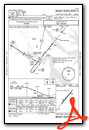
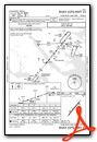
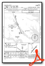
Instrument Approach Procedure (IAP) Charts
Nearby Airports with Instrument Procedures
| ID | Name | Heading / Distance | ||
|---|---|---|---|---|
 |
KJGG | Waltrip Williamsburg Exec Airport Airport | 220° | 5.8 |
|
KFAF | Felker AAF Airport | 172° | 10.9 |
|
KPHF | Newport News/Williamsburg International Airport | 147° | 12.9 |
|
KFYJ | Middle Peninsula Regional Airport | 334° | 13.8 |
|
KLFI | Langley AFB Airport | 135° | 19.2 |
|
W75 | Hummel Field Airport | 027° | 19.7 |
|
W96 | New Kent County Airport | 296° | 26.0 |
|
KAKQ | Wakefield Municipal Airport | 221° | 26.1 |
|
KNGU | Norfolk Ns (Chambers Field) Airport | 143° | 28.0 |
|
KORF | Norfolk International Airport | 139° | 32.7 |
|
KPVG | Hampton Roads Exec Airport | 164° | 33.1 |
|
KRIC | Richmond International Airport | 289° | 34.6 |
Airport Images
Do you have a recent image of this airport? Upload it here!


