Login
Register


IDI
Indiana County/Jimmy Stewart Field Airport
Official FAA Data Effective 2024-12-26 0901Z
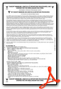
Chart Supplement

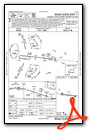
VFR Chart of KIDI
Sectional Charts at SkyVector.com
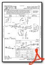
IFR Chart of KIDI
Enroute Charts at SkyVector.com
Location Information for KIDI
Coordinates: N40°37.86' / W79°6.09'Located 02 miles E of Indiana, Pennsylvania on 320 acres of land. View all Airports in Pennsylvania.
Surveyed Elevation is 1419 feet MSL.
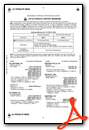
Operations Data
|
|
Airport Communications
| AWOS-3: | 126.625 Tel. 724-388-0204 |
|---|---|
| JOHNSTOWN APPROACH: | 121.2 299.2 |
| JOHNSTOWN DEPARTURE: | 121.2 299.2 |
| UNICOM: | 122.800 |
| CTAF: | 122.800 |
| ATIS at JST (22.5 SE): | 118.325 |
| ASOS at JST (22.5 SE): | 814-535-3511 |
| AWOS-3 at LBE (25.4 SW): | 724-537-0671 |
- APCH/DEP SVC PRVDD BY CLEVELAND ARTCC (ZOB) ON FREQS 124.4/299.2 (ALTOONA RCAG) WHEN JOHNSTOWN APCH CTL CLSD.
Nearby Navigation Aids
|
| ||||||||||||||||||||||||||||||||||||||||||||||||||||||||||||


Runway 11/29
| Dimensions: | 5502 x 100 feet / 1677 x 30 meters | |
|---|---|---|
| Surface: | Asphalt in Good Condition | |
| Edge Lighting: | High Intensity | |
| Runway 11 | Runway 29 | |
| Coordinates: | N40°37.91' / W79°6.68' | N40°37.81' / W79°5.50' |
| Elevation: | 1367.2 | 1419.1 |
| Traffic Pattern: | Left | Left |
| Runway Heading: | 96° True | 276° True |
| Markings: | Non-Precision Instrument in good condition. | Precision Instrument in good condition. |
| Glide Slope Indicator | P4L (3.00° Glide Path Angle) | P4L (3.00° Glide Path Angle) |
| REIL: | Yes | |
| Obstacles: | 83 ft Trees 1485 ft from runway, 623 ft left of center | 137 ft Trees 3158 ft from runway, 660 ft left of center |
Services Available
| Fuel: | 100LL (blue), Jet-A, Jet A+ |
|---|---|
| Transient Storage: | Hangars,Tiedowns |
| Airframe Repair: | MINOR |
| Engine Repair: | MINOR |
| Bottled Oxygen: | NONE |
| Bulk Oxygen: | NONE |
| Other Services: | PILOT INSTRUCTION,AIRCRAFT RENTAL |
Ownership Information
| Ownership: | Publicly owned | |
|---|---|---|
| Owner: | COUNTY OF INDIANA | |
| 398 AIRPORT ROAD | ||
| INDIANA, PA 15701 | ||
| 724-463-3883 | ||
| Manager: | FREDERICK FUELLNER | |
| 398 AIRPORT ROAD | ||
| INDIANA, PA 15701 | ||
| 724-463-3883 | ||
Other Remarks
- BIRDS & DEER ON & INVOF ARPT.
- FOR CD CTC JOHNSTOWN APCH AT 814-532-5960, WHEN APCH CLSD CTC CLEVELAND ARTCC AT 440-774-0213.
- 0LL 24 HR 100LL AVBL WITH CREDIT CARD.
- ACTIVATE REIL RWY 11; PAPI RWY 11 & 29; HIRL RWY 11/29 & TWYS - CTAF.
Weather Minimums
Instrument Approach Procedure (IAP) Charts
Nearby Airports with Instrument Procedures
| ID | Name | Heading / Distance | ||
|---|---|---|---|---|
 |
9G8 | Ebensburg Airport | 124° | 18.1 |
|
N35 | Punxsutawney Municipal Airport | 021° | 21.6 |
|
KJST | John Murtha Johnstown/Cambria County Airport | 147° | 22.5 |
|
6P7 | Mcville Airport | 285° | 23.4 |
|
KLBE | Arnold Palmer Regional Airport | 213° | 25.7 |
|
KDUJ | Dubois Regional Airport | 015° | 34.1 |
|
2G9 | Somerset County Airport | 173° | 35.7 |
|
KAXQ | Clarion County Airport | 336° | 38.8 |
|
KBTP | Pittsburgh/Butler Regional Airport | 282° | 39.7 |
|
KFIG | Clearfield-Lawrence Airport | 051° | 40.1 |
|
KAOO | Altoona/Blair County Airport | 119° | 41.0 |
|
KAGC | Allegheny County Airport | 246° | 41.4 |


Comments
A Great Airport to Visit
An excellent airport! I flew there to visit the Jimmy Stewart Museum which is well worth visiting. The airport treated me royally and provided the club car for me to go to the museum. FBO is very nice with a restuarant. I can highly recommend adding this airport and museum to your bucket list.
Daniel J Ward
Pages