Login
Register
7GA7
Berry Hill Airport
Official FAA Data Effective 2026-01-22 0901Z
VFR Chart of 7GA7
Sectional Charts at SkyVector.com
IFR Chart of 7GA7
Enroute Charts at SkyVector.com
Location Information for 7GA7
Coordinates: N33°32.13' / W84°10.74'Located 03 miles E of Stockbridge, Georgia on 23 acres of land. View all Airports in Georgia.
Estimated Elevation is 770 feet MSL.
Operations Data
|
|
Airport Communications
| UNICOM: | 122.800 |
|---|---|
| AWOS-3 at HMP (11.5 SW): | 124.825 770-707-1719 |
| D-ATIS at ATL (13.8 NW): | 119.65 ;ARR |
| ASOS at ATL (13.9 NW): | 404-559-5166 |
Nearby Navigation Aids
|
| ||||||||||||||||||||||||||||||||||||||||||||||||||||||||||||
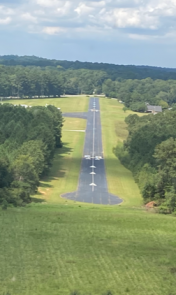
Runway 11/29
| Dimensions: | 3000 x 40 feet / 914 x 12 meters | |
|---|---|---|
| Surface: | Asphalt in Fair Condition | |
| Edge Lighting: | Non-Standard RWY LGTS NTSD IN NR, TYPE, AND GLOBE COLOR; NO LGTS AT DSPLCD THLD. | |
| Runway 11 | Runway 29 | |
| Coordinates: | N33°32.22' / W84°11.02' | N33°32.05' / W84°10.47' |
| Traffic Pattern: | Left | Left |
| Markings: | Non-Standard in fair condition. | Non-Standard in fair condition. |
| Obstacles: | 30 ft Power Line 200 ft from runway RWY 11 APCH RATIO 5:1 TO DSPLCD THLD. 38 FT TREES 190 FT FROM DSPLCD THLD & 150 FT RIGHT. RWY 11 PLINE, +40 FT TREES, & ROAD AT RWY END. |
115 ft Trees 545 ft from runway RWY 29 APCH RATIO 0:1 TO DSPLCD THLD. +30 FT TREES 69 FT RIGHT & 40 FT TREES 50 FT LEFT AT DSPLCD THLD. RWY 29 +30-50 FT TREES AND BRUSH 30 FT RIGHT AND 50 FT LEFT OF CNTRLN AT RWY END. |
Services Available
| Fuel: | 100LL (blue) |
|---|---|
| Transient Storage: | Hangars,Tiedowns |
| Airframe Repair: | NONE |
| Engine Repair: | NONE |
| Bottled Oxygen: | NONE |
| Bulk Oxygen: | NONE |
Ownership Information
| Ownership: | Privately Owned | |
|---|---|---|
| Owner: | FRIENDS OF BERRY HILL | |
| 555 MILLERS MILL RD | ||
| STOCKBRIDGE, GA 30281 | ||
| 404-213-8213 | ||
| Manager: | TOM BAXTER | |
| 45 CESSNA LN | ||
| STOCKBRIDGE, GA 30281 | ||
Other Remarks
- FOR CD CTC ATLANTA APCH AT 678-364-6131.
- RWY 11/29 NTSD BSC MARKING, NRS SMALL.
- 0LL FOR FUEL WHEN UNATNDD CALL: 770-316-3948 OR 770-235-6027.
- RDO-CTL.
Nearby Airports with Instrument Procedures
| ID | Name | Heading / Distance | ||
|---|---|---|---|---|
 |
KHMP | Atlanta Speedway Airport | 221° | 11.6 |
 |
KATL | Hartsfield/Jackson Atlanta International Airport | 295° | 13.9 |
 |
KCVC | Covington Municipal Airport | 070° | 17.6 |
 |
6A2 | Griffin-Spalding County Airport | 194° | 19.1 |
 |
KPDK | Dekalb-Peachtree Airport | 343° | 21.3 |
 |
KFFC | Atlanta Regional Falcon Field Airport | 241° | 22.4 |
 |
KFTY | Fulton County Exec/Charlie Brown Field Airport | 310° | 22.5 |
 |
KMGE | Dobbins Arb Airport | 323° | 28.2 |
 |
D73 | Cy Nunnally Memorial Airport | 058° | 28.5 |
 |
KLZU | Gwinnett County/Briscoe Field Airport | 022° | 28.6 |
 |
KCCO | Newnan Coweta County Airport | 245° | 32.6 |
 |
KOPN | Thomaston-Upson County Airport | 187° | 35.0 |


Comments
Ownership Information change:
Ownership Information change:
Friends of Berry Hill
45 Cessna Lane
Stockbridge, GA 30281
404 213 8213
Manager:
Tom Baxter
45 Cessna Lane
Stockbridge, GA 30281