Login
Register


N14
Flying W Airport
Official FAA Data Effective 2025-12-25 0901Z
Chart Supplement

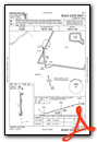
VFR Chart of N14
Sectional Charts at SkyVector.com
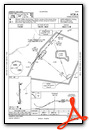
IFR Chart of N14
Enroute Charts at SkyVector.com
Location Information for N14
Coordinates: N39°56.06' / W74°48.43'Located 01 miles SW of Lumberton, New Jersey on 170 acres of land. View all Airports in New Jersey.
Surveyed Elevation is 49 feet MSL.
Operations Data
|
|
Airport Communications
| MC GUIRE APPROACH: | 126.475 363.8 |
|---|---|
| MC GUIRE DEPARTURE: | 126.475 363.8 |
| UNICOM: | 122.800 |
| CTAF: | 122.800 |
| ASOS at VAY (1.8 W): | 119.325 609-267-1176 |
| D-ATIS at WRI (11.1 NE): | 110.6 |
| ATIS at PNE (12.9 NW): | 121.15 |
Nearby Navigation Aids
|
| ||||||||||||||||||||||||||||||||||||||||||||||||||||||||||||


Runway 01/19
| Dimensions: | 3496 x 75 feet / 1066 x 23 meters | |
|---|---|---|
| Surface: | Asphalt in Fair Condition | |
| Edge Lighting: | Medium Intensity | |
| Runway 01 | Runway 19 | |
| Coordinates: | N39°55.77' / W74°48.42' | N39°56.34' / W74°48.45' |
| Elevation: | 35.0 | 49.1 |
| Traffic Pattern: | Right | |
| Runway Heading: | 358° True | 178° True |
| Markings: | Non-Precision Instrument in good condition. | Non-Precision Instrument in good condition. |
| Glide Slope Indicator | P2L (3.50° Glide Path Angle) | P2L (3.20° Glide Path Angle) |
| REIL: | Yes REILS INOP. | Yes REILS INOP. |
| Obstacles: | 89 ft Trees 262 ft from runway, 169 ft right of center TREE, +42 FT HIGH, 43 FT FM THLD, 102 FT R. |
|
Services Available
| Fuel: | 100LL (blue), Jet-A |
|---|---|
| Transient Storage: | Tiedowns |
| Airframe Repair: | MINOR |
| Engine Repair: | MINOR |
| Bottled Oxygen: | NONE |
| Bulk Oxygen: | NONE |
| Other Services: | PILOT INSTRUCTION,AIRCRAFT RENTAL |
Ownership Information
| Ownership: | Privately Owned | |
|---|---|---|
| Owner: | CAVE HOLDINGS-FLYING W, LLC | |
| 60 FOSTERTOWN RD | ||
| MEDFORD, NJ 08055 | ||
| 609-261-7880 | ||
| Manager: | MINDY KIMBALL | |
| 60 FOSTERTOWN RD | ||
| MEDFORD, NJ 08055 | ||
| 609-267-7673 | ||
Other Remarks
- EAST-WEST RAVINE CROSSES EXTD CNTRLN RWY 01, 100 FT FM THLD.
- DEEP RETENTION POND 23 FT WEST OF PARALLEL TWY CNTRLN, NORTH OF OPS BLDG.
- FOR CD CTC MC GUIRE APCH AT 609-754-2767.
- DEER & BIRDS ON & INVOF ARPT.
- ACTVT MIRL, PAPI, REIL AND TWY LGTS - CTAF.
Weather Minimums
Standard Terminal Arrival (STAR) Charts

Instrument Approach Procedure (IAP) Charts

Nearby Airports with Instrument Procedures
| ID | Name | Heading / Distance | ||
|---|---|---|---|---|
 |
KVAY | South Jersey Regional Airport | 286° | 1.9 |
|
KWRI | Mc Guire Field (Joint Base Mc Guire Dix Lakehurst) Airport | 063° | 11.1 |
|
19N | Pine Valley Airport | 214° | 11.4 |
|
KPNE | Northeast Philadelphia Airport | 313° | 12.9 |
|
N81 | Hammonton Municipal Airport | 171° | 16.2 |
|
17N | Cross Keys Airport | 217° | 17.2 |
|
N87 | Trenton-Robbinsville Airport | 029° | 19.3 |
|
KPHL | Philadelphia International Airport | 259° | 20.4 |
|
KTTN | Trenton Mercer Airport | 359° | 20.5 |
|
KNEL | Lakehurst Maxfield Field Airport | 073° | 21.9 |
|
KMJX | Ocean County Airport | 091° | 23.6 |
|
KLOM | Wings Field Airport | 300° | 24.4 |
Airport Images
Do you have a recent image of this airport? Upload it here!


Comments
Stay away
Flying W is a beautiful airport, unfortunately there is a group of fighter pilot wannabes that operate there. They have no regards for safety at all. They practice dangerous maneuvers both in the pattern and on the ground. I was hoping that after one of these idiots ran into another plane on the ramp while doing a high speed taxi (no worries, they hid it from the FAA), that they would shape up or ship out. Unfortunately they were still there when I flew in last weekend, and are more wreckless than ever. It's only a matter of time before these idiots cause a major accident. Flying W has too much traffic for people to play games.
Complaint follow up
The Flying W prides itself on being the home to many vintage aircraft. This group has performed in many air shows and follow all regulations set by the FAA. Many visitors of the Flying W enjoy seeing the war planes. These pilots have generously shown their aircrafts to many children and adults to further general aviation to the next generation. I assure you that no accidents have occurred at the flying w that have not been reported to the FAA.
The Flying W is a great place to come for breakfast or lunch and see all the activity. We have an airplane shaped pool a tiki bar and a monthly pancake breakfast that make us a great destination for a flight. We even have a 28 room motel in case you decide to stay awhile.
MR