Login
Register


84R
Smithville Crawford Municipal Airport
Official FAA Data Effective 2024-07-11 0901Z
Chart Supplement

VFR Chart of 84R
Sectional Charts at SkyVector.com
IFR Chart of 84R
Enroute Charts at SkyVector.com
Location Information for 84R
Coordinates: N30°1.69' / W97°10.02'Located 02 miles N of Smithville, Texas on 63 acres of land. View all Airports in Texas.
Surveyed Elevation is 323 feet MSL.
Operations Data
|
|
Airport Communications
| AUSTIN APPROACH: | 120.875 270.25 |
|---|---|
| AUSTIN DEPARTURE: | 120.875 270.25 |
| CTAF: | 122.900 |
| AWOS-3 at GYB (13.0 NE): | 119.225 979-542-0382 |
| AWOS-3 at 3T5 (13.4 SE): | 124.175 979-242-5777 |
| D-ATIS at AUS (28.0 W): | 124.4 |
Nearby Navigation Aids
|
| ||||||||||||||||||||||||||||||||||||||||||||||||||||||||||||


Runway 17/35
| Dimensions: | 4000 x 75 feet / 1219 x 23 meters | |
|---|---|---|
| Surface: | Asphalt in Good Condition | |
| Weight Limits: | S-12 | |
| Edge Lighting: | Medium Intensity | |
| Runway 17 | Runway 35 | |
| Coordinates: | N30°2.02' / W97°10.08' | N30°1.37' / W97°9.97' |
| Elevation: | 323.2 | 322.0 |
| Traffic Pattern: | Left | Left |
| Runway Heading: | 172° True | 352° True |
| Markings: | Non-Precision Instrument in good condition. | Non-Precision Instrument in good condition. |
| Glide Slope Indicator | P2L (4.00° Glide Path Angle) | P2L (3.00° Glide Path Angle) |
| Obstacles: | 106 ft Trees 2200 ft from runway, 30 ft left of center | 35 ft Trees 920 ft from runway, 109 ft right of center |
Services Available
| Fuel: | 100LL (blue) |
|---|---|
| Transient Storage: | Hangars,Tiedowns |
| Airframe Repair: | MAJOR |
| Engine Repair: | MAJOR |
| Bottled Oxygen: | NONE |
| Bulk Oxygen: | NONE |
| Other Services: | PILOT INSTRUCTION |
Ownership Information
| Ownership: | Publicly owned | |
|---|---|---|
| Owner: | CITY OF SMITHVILLE | |
| PO BOX 449 | ||
| SMITHVILLE, TX 78957 | ||
| 512-237-3282 | ||
| Manager: | ROBERT TAMBLE | |
| BOX 449 | ||
| SMITHVILLE, TX 78957 | ||
| 512-237-3282 | ON SITE ARPT CTC SANDY MEYERSON 979-224-6304, SMBUILDS@GMAIL.COM. | |
Operational Statistics
| Single Engine Aircraft Based on Field: | 27 | Statistics collected for 12 month period ending 2023-05-23 | |
|---|---|---|---|
| Multi-Engine Aircraft Based on Field: | 2 | Annual Commercial Operations: | none |
| Jet Aircraft Based on Field: | none | Annual Commuter Operations: | none |
| Helicopters Based on Field: | 2 | Annual Air Taxi Operations: | none |
| Military Aircraft Based on Field: | none | Annual Military Operations: | 520 |
| Gliders Based on Field: | none | Annual GA Local Operations: | 12600 |
| Ultralights Based on Field: | 3 | Annual GA Itinerant Operations: | 4201 |
Other Remarks
- WILDLIFE & LIVESTOCK INVOF ARPT.
- FOR CD CTC AUSTIN APCH AT 512-369-7865.
- 35 FT MKD/LGTD PLINE 1300 FT DSTC, ACRS APCH.
- SS-SR ACTVT MIRL RWY 17/35 123.3; PAPI OPR CONSLY.
Weather Minimums
Instrument Approach Procedure (IAP) Charts
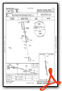
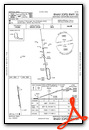
Nearby Airports with Instrument Procedures
| ID | Name | Heading / Distance | ||
|---|---|---|---|---|
 |
KGYB | Giddings-Lee County Airport | 049° | 12.9 |
|
3T5 | Fayette Regional Air Center Airport | 122° | 13.4 |
|
KAUS | Austin-Bergstrom International Airport | 290° | 28.0 |
|
50R | Lockhart Municipal Airport | 248° | 28.4 |
|
KEDC | Austin Exec Airport | 316° | 30.3 |
|
T74 | Taylor Municipal Airport | 336° | 35.6 |
|
KHYI | San Marcos Regional Airport | 257° | 37.2 |
|
KRWV | Caldwell Municipal Airport | 039° | 37.8 |
|
11R | Brenham Municipal Airport | 074° | 42.8 |
|
T85 | Yoakum Municipal Airport | 177° | 42.8 |
|
KGTU | Georgetown Exec Airport | 325° | 47.2 |
|
3R9 | Lakeway Airpark Airport | 294° | 47.3 |
Airport Images

By: smbuilds@gmail.com


Comments
PCL
Activate MIRL RWY 17/35 on 123.3 not CTAF.