Login
Register
LEX
Blue Grass Airport
Official FAA Data Effective 2025-04-17 0901Z
VFR Chart of KLEX
Sectional Charts at SkyVector.com
IFR Chart of KLEX
Enroute Charts at SkyVector.com
Location Information for KLEX
Coordinates: N38°2.20' / W84°36.52'Located 04 miles W of Lexington, Kentucky on 911 acres of land. View all Airports in Kentucky.
Surveyed Elevation is 979 feet MSL.
Operations Data
|
|
Airport Communications
| ATIS: | 126.3 |
|---|---|
| ASOS: | Tel. 859-281-5700 |
| LEXINGTON TOWER: | 119.1 257.8 |
| LEXINGTON GROUND: | 121.9 |
| LEXINGTON APPROACH: | 120.15 ;040-220 120.75 ;221-039 133.4 ;040-220 259.3 ;040-220 298.9 ;221-039 |
| LEXINGTON DEPARTURE: | 120.15 ;040-220 120.75 ;221-039 133.4 ;040-220 259.3 ;040-220 298.9 ;221-039 |
| CLEARANCE DELIVERY: | 132.35 |
| CLASS C: | 120.15 ;040-220 120.75 ;221-039 259.3 ;040-220 298.9 ;221-039 |
| UNICOM: | 122.950 |
| EMERG: | 121.5 243.0 |
| AWOS-3 at 27K (14.7 NE): | 119.975 502-867-1564 |
| ASOS at FFT (16.6 NW): | 119.275 502-227-5087 |
| AWOS-3 at RGA (27.6 SE): | 119.625 859-985-5969 |
Nearby Navigation Aids
|
| ||||||||||||||||||||||||||||||||||||||||||||||||||||||||||||
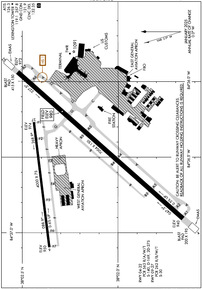
Runway 04/22
| Dimensions: | 7004 x 150 feet / 2135 x 46 meters | |
|---|---|---|
| Surface: | Asphalt / Grooved in Good Condition | |
| Weight Limits: | S-140, D-169, ST-275
PCR VALUE: 563/R/A/W/T
| |
| Edge Lighting: | High Intensity | |
| Runway 04 | Runway 22 | |
| Coordinates: | N38°1.66' / W84°36.91' | N38°2.52' / W84°35.94' |
| Elevation: | 940.0 | 972.7 |
| Traffic Pattern: | Left | Left |
| Runway Heading: | 42° True | 222° True |
| Declared Distances: | TORA:7004 TODA:7004 ASDA:7004 LDA:6604 | TORA:7004 TODA:7004 ASDA:7004 LDA:6604 |
| Markings: | Precision Instrument in good condition. | Precision Instrument in good condition. |
| Glide Slope Indicator | P4L (3.00° Glide Path Angle) | P4L (3.00° Glide Path Angle) |
| RVR Equipment | Touchdown | |
| Approach Lights: | MALSR 1,400 Foot Medium-intensity Approach Lighting System with runway alignment indicator lights. | |
| REIL: | Yes | |
| Centerline Lights: | Yes | Yes |
| Obstacles: | 36 ft Tree 2000 ft from runway, 210 ft right of center | 54 ft Tree 1980 ft from runway, 120 ft left of center |
Runway 09/27
NOT AVBL FOR SKED ACR OPS MORE THAN 9 PAX SEATS OR UNSKED ACR AT LEAST 31 PAX SEATS. | ||
| Dimensions: | 4000 x 75 feet / 1219 x 23 meters | |
|---|---|---|
| Surface: | Concrete in Good Condition | |
| Weight Limits: | S-30
PCR VALUE: 262/R/B/W/T
| |
| Edge Lighting: | Medium Intensity | |
| Runway 09 | Runway 27 | |
| Coordinates: | N38°2.36' / W84°37.10' | N38°2.44' / W84°36.27' |
| Elevation: | 950.4 | 974.0 |
| Runway Heading: | 83° True | 263° True |
| Declared Distances: | TORA:4000 TODA:4000 ASDA:4000 LDA:4000 | TORA:4000 TODA:4000 ASDA:4000 LDA:4000 |
| Markings: | Non-Precision Instrument in good condition. | Non-Precision Instrument in good condition. |
| Glide Slope Indicator | P4L (3.00° Glide Path Angle) | P4L (3.00° Glide Path Angle) |
| REIL: | Yes | Yes |
Services Available
| Fuel: | 100LL (blue), Jet-A |
|---|---|
| Transient Storage: | Hangars,Tiedowns |
| Airframe Repair: | MAJOR |
| Engine Repair: | MAJOR |
| Bottled Oxygen: | HIGH |
| Bulk Oxygen: | HIGH/LOW |
| Other Services: | AIR FREIGHT SERVICES,AIR AMBULANCE SERVICES,AVIONICS,CARGO HANDLING SERVICES,CHARTER SERVICE,PILOT INSTRUCTION,AIRCRAFT RENTAL,AIRCRAFT SALES |
Ownership Information
| Ownership: | Publicly owned | |
|---|---|---|
| Owner: | LEXINGTON-FAYETTE CO ARPT BRD | |
| 4000 TERMINAL DRIVE, SUITE 206 | ||
| LEXINGTON, KY 40510 | ||
| 859-425-3100 | ||
| Manager: | ERIC J. FRANKL, A.A.E. | |
| 4000 TERMINAL DRIVE, SUITE 206 | ||
| LEXINGTON, KY 40510 | ||
| 859-425-3100 | ||
Other Remarks
- FLIGHT NOTIFICATION SERVICE (ADCUS) AVBL.
- TWY B & TWY F WEST OF TWY F3; NOT AVBL FOR SKED ACR OPS MORE THAN 9 PAX SEATS OR UNSKED ACR AT LEAST 31 PAX SEATS; CLSD TO ACFT WITH WINGSPAN GREATER THAN 78 FT.
- DURG L PAT DO NOT MISTAKE RWY 27 FOR RWY 22. WALL MURAL BFR THR GIVES ILLUSION OF A BRIDGE.
- ENGINEERED MATERIAL ARRESTING SYSTEM (EMAS) 316 FT IN LENGTH BY 170 FT IN WIDTH STARTING 186 FT DER 04.
- ENGINEERED MATERIAL ARRESTING SYSTEM (EMAS) 283 FT IN LENGTH BY 170 FT IN WIDTH STARTING 307 FT DER 22.
Weather Minimums
Instrument Approach Procedure (IAP) Charts
Nearby Airports with Instrument Procedures
| ID | Name | Heading / Distance | ||
|---|---|---|---|---|
 |
27K | Georgetown-Scott County Regional Airport | 034° | 14.4 |
 |
KFFT | Capital City Airport | 301° | 16.6 |
 |
0I8 | Cynthiana-Harrison County Airport | 037° | 25.0 |
 |
KRGA | Central Kentucky Regional Airport | 151° | 27.6 |
 |
KDVK | Stuart Powell Field Airport | 195° | 28.6 |
 |
KIOB | Mount Sterling/Montgomery County Airport | 087° | 29.8 |
 |
6I2 | Lebanon Springfield-George Hoerter Field Airport | 231° | 38.6 |
 |
K62 | Gene Snyder Airport | 014° | 41.3 |
 |
KBRY | Samuels Field Airport | 252° | 44.4 |
 |
KSYM | Morehead-Rowan County Clyde A Thomas Regional Airport | 077° | 49.5 |
 |
KFGX | Fleming-Mason Airport | 053° | 50.8 |
 |
KLOU | Bowman Field Airport | 283° | 51.2 |


