Login
Register
GRI
Central Nebraska Regional Airport
Official FAA Data Effective 2024-12-26 0901Z
VFR Chart of KGRI
Sectional Charts at SkyVector.com
IFR Chart of KGRI
Enroute Charts at SkyVector.com
Location Information for KGRI
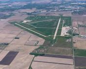
Coordinates: N40°58.05' / W98°18.58'Located 03 miles NE of Grand Island, Nebraska on 1847 acres of land. View all Airports in Nebraska.
Estimated Elevation is 1847 feet MSL.
Operations Data
|
|
Airport Communications
| ATIS: | 127.4 |
|---|---|
| ASOS: | Tel. 308-382-5590 |
| GRAND ISLAND TOWER: | 118.2 259.3 |
| GRAND ISLAND GROUND: | 121.9 259.3 |
| CLEARANCE DELIVERY: | 121.9 |
| UNICOM: | 122.950 |
| ARNG OPS: | 140.5 242.4 38.3 |
| CTAF: | 118.200 |
| AWOS-3 at AUH (15.0 E): | 121.225 402-694-5472 |
| ASOS at HSI (22.4 S): | 120.525 402-463-4029 |
| AWOS-3 at JYR (31.4 E): | 124.175 402-362-3785 |
- APCH/DEP SVC PRVDD BY MINNEAPOLIS ARTCC ON FREQS 119.4/278.8 (HASTINGS RCAG).
- CLEARANCE DELIVERY PRVDD BY MINNEAPOLIS ARTCC ON FREQ 126.05 (GRAND ISLAND RCAG) WHEN GRI ATCT CLSD.
Nearby Navigation Aids
|
| ||||||||||||||||||||||||||||||||||||||||||||||||||||||||||||
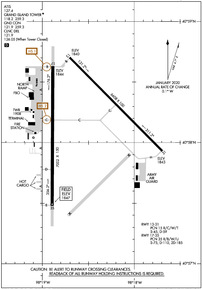
Runway 17/35
| Dimensions: | 7002 x 150 feet / 2134 x 46 meters | |
|---|---|---|
| Surface: | Concrete / Grooved in Excellent Condition | |
| Weight Limits: | 35 /R/B/W/U, S-75, D-110, ST-185 | |
| Edge Lighting: | High Intensity | |
| Runway 17 | Runway 35 | |
| Coordinates: | N40°58.63' / W98°18.89' | N40°57.48' / W98°18.89' |
| Elevation: | 1843.7 | 1846.7 |
| Traffic Pattern: | Left | Left |
| Runway Heading: | 180° True | 0 |
| Declared Distances: | TORA:7002 TODA:7002 ASDA:7002 LDA:7002 | TORA:7002 TODA:7002 ASDA:7002 LDA:7002 |
| Markings: | Non-Precision Instrument in good condition. | Precision Instrument in good condition. |
| Glide Slope Indicator | P4L (3.00° Glide Path Angle) | P4L (2.60° Glide Path Angle) PAPI RESTRICTED BYD 6 DEG RIGHT OF CNTRL. |
| RVR Equipment | Rollout | Touchdown |
| Approach Lights: | MALS 1,400 Foot Medium-intensity Approach Lighting System. | MALSR 1,400 Foot Medium-intensity Approach Lighting System with runway alignment indicator lights. |
Runway 13/31
| Dimensions: | 6608 x 100 feet / 2014 x 30 meters | |
|---|---|---|
| Surface: | Concrete in Excellent Condition | |
| Weight Limits: | 15 /R/C/W/T, S-45, D-59 | |
| Edge Lighting: | Medium Intensity | |
| Runway 13 | Runway 31 | |
| Coordinates: | N40°58.70' / W98°18.70' | N40°57.93' / W98°17.69' |
| Elevation: | 1840.0 | 1843.0 |
| Traffic Pattern: | Left | Left |
| Runway Heading: | 135° True | 315° True |
| Declared Distances: | TORA:6608 TODA:6608 ASDA:6608 LDA:6608 | TORA:6608 TODA:6608 ASDA:6608 LDA:6608 |
| Markings: | Non-Precision Instrument in good condition. | Non-Precision Instrument in good condition. |
| Glide Slope Indicator | P4L (3.00° Glide Path Angle) | P4L (3.00° Glide Path Angle) |
| Approach Lights: | MALS 1,400 Foot Medium-intensity Approach Lighting System. | |
| REIL: | Yes | |
Services Available
| Fuel: | 100LL (blue), Jet-A |
|---|---|
| Transient Storage: | Hangars,Tiedowns |
| Airframe Repair: | MAJOR |
| Engine Repair: | MAJOR |
| Bottled Oxygen: | NONE |
| Bulk Oxygen: | HIGH/LOW |
| Other Services: | AIR FREIGHT SERVICES,AIR AMBULANCE SERVICES,AVIONICS,CARGO HANDLING SERVICES,CHARTER SERVICE,PILOT INSTRUCTION |
Ownership Information
| Ownership: | Publicly owned | |
|---|---|---|
| Owner: | HALL COUNTY ARPT AUTH | |
| 3579 SKY PARK ROAD | ||
| GRAND ISLAND, NE 68801 | ||
| 308-385-5170 | ||
| Manager: | MR. MICHAEL OLSON, A.A.E. | |
| 3855 SKY PARK ROAD | ||
| GRAND ISLAND, NE 68801 | ||
| 308-385-5170 | OR 308-385-5172. | |
Other Remarks
- THIS AIRPORT HAS BEEN SURVEYED BY THE NATIONAL GEODETIC SURVEY.
- COMPRESSED NITROGEN FOR STRUT INFLATION AVBL.
- INBOUND ACFT CTC OPS 10 MIN PRIOR TO LNDG.
- ARNG: OPR 0730-1600++MON-FRI; OCNL WKEND. PPR TO PRK ARNG RAMP. DSN 279-8691, C402-309-8691.
- MIGRATORY WATERFOWL ON & INVOF ARPT.
- TWY DELTA EXIT OFF RY 17/35 CLSD TO LARGE ACFT DUE TO INADEQUATE TURNING RADIUS.
- ACTVT PAPI RWY 31 & 35 - CTAF. WHEN TWR CLSD ACTVT MALS RWY 13 & 17; MALSR RWY 35; REIL RWY 31; PAPI RWY 13 & 17; MIRL RWY 13/31; HIRL RWY 17/35 - CTAF.
Weather Minimums
Instrument Approach Procedure (IAP) Charts
Nearby Airports with Instrument Procedures
| ID | Name | Heading / Distance | ||
|---|---|---|---|---|
 |
07K | Central City Municipal/Larry Reineke Field Airport | 053° | 14.6 |
 |
KAUH | Aurora Municipal/Al Potter Field Airport | 106° | 15.0 |
 |
08K | Harvard State Airport | 151° | 21.7 |
 |
KHSI | Hastings Municipal Airport | 193° | 22.4 |
 |
KJYR | York Municipal Airport | 097° | 31.5 |
 |
KEAR | Kearney Regional Airport | 245° | 34.9 |
 |
0F4 | Loup City Municipal Airport | 302° | 36.3 |
 |
0V3 | Pioneer Village Field Airport | 227° | 39.7 |
 |
KFMZ | Fairmont State Airport | 124° | 40.6 |
 |
KBVN | Albion Municipal Airport | 014° | 47.1 |
 |
KODX | Evelyn Sharp Field Airport | 323° | 48.9 |
 |
KOLU | Columbus Municipal Airport | 056° | 52.5 |


