Login
Register


EKN
Elkins/Randolph County (Jennings Randolph Field) Airport
Official FAA Data Effective 2024-11-28 0901Z
Chart Supplement

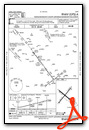
VFR Chart of KEKN
Sectional Charts at SkyVector.com
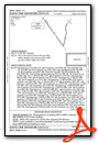
IFR Chart of KEKN
Enroute Charts at SkyVector.com
Location Information for KEKN
Coordinates: N38°53.37' / W79°51.43'Located 02 miles S of Elkins, West Virginia on 227 acres of land. View all Airports in West Virginia.
Surveyed Elevation is 1987 feet MSL.
Operations Data
|
|
Airport Communications
| ASOS: | 119.275 Tel. 304-636-5603 |
|---|---|
| CLARKSBURG APPROACH: | 121.15 284.65 |
| CLARKSBURG DEPARTURE: | 121.15 284.65 |
| CTAF: | 123.600 |
| AWOS-3 at W22 (20.6 W): | 119.975 304-472-9428 |
| ATIS at CKB (30.0 NW): | 127.825 |
| ASOS at CKB (30.0 NW): | 304-842-9240 |
- APCH/DEP SVC PRVDD BY WASHINGTON ARTCC ON FREQS 128.6/226.675 (ELKINS RCAG) WHEN CLARKSBURG APCH CTL CLSD.
Nearby Navigation Aids
|
| ||||||||||||||||||||||||||||||||||||||||||||||||||||||||||||


Runway 14/32
| Dimensions: | 4544 x 140 feet / 1385 x 43 meters | |
|---|---|---|
| Surface: | Asphalt in Good Condition | |
| Weight Limits: | S-10 | |
| Runway 14 | Runway 32 | |
| Coordinates: | N38°53.58' / W79°51.76' | N38°53.11' / W79°51.01' |
| Elevation: | 1940.0 | 1987.0 |
| Traffic Pattern: | Left | Left |
| Runway Heading: | 129° True | 309° True |
| Displaced Threshold: | 1390 Feet | |
| Markings: | Basic in poor condition. | Basic in poor condition. |
| Obstacles: | 68 ft Tree 600 ft from runway, 285 ft right of center | 90 ft Trees 201 ft from runway, 235 ft right of center APCH SLOPE 8:1 AT DSPLCD THR OVR 156 FT TREE, 1400 FT DSTC, 300 FT L. 156 FT TREES, 110 FT DSTC, 220 FT L. 30 FT HGR, 0 FT DSTC, 149 FT L. |
Runway 05/23
| Dimensions: | 4501 x 75 feet / 1372 x 23 meters | |
|---|---|---|
| Surface: | Asphalt in Fair Condition | |
| Weight Limits: | S-28, D-35, ST-56 | |
| Edge Lighting: | Medium Intensity | |
| Runway 05 | Runway 23 | |
| Coordinates: | N38°53.10' / W79°51.77' | N38°53.68' / W79°51.17' |
| Elevation: | 1973.5 | 1947.0 |
| Traffic Pattern: | Left | |
| Runway Heading: | 39° True | 219° True |
| Displaced Threshold: | 154 Feet | |
| Markings: | Non-Precision Instrument in good condition. | Non-Precision Instrument in good condition. |
| Glide Slope Indicator | P2L (5.00° Glide Path Angle) PAPI NON-STD 5 DEG GA. | |
| REIL: | Yes | |
| Obstacles: | 45 ft Trees 201 ft from runway, 176 ft left of center 86 FT ANTENNA, 850 FM RWY END 180 FT R, APCH SLOPE 11:1 TO DSPLCD THR. 30 FT TREES, 64-199 FT DSTC, 248 FT R. |
258 ft Antenna 2135 ft from runway, 480 ft right of center |
Services Available
| Fuel: | 100LL (blue), Jet-A |
|---|---|
| Transient Storage: | Hangars,Tiedowns |
| Airframe Repair: | NOT AVAILABLE |
| Engine Repair: | NOT AVAILABLE |
| Bottled Oxygen: | NONE |
| Bulk Oxygen: | NONE |
| Other Services: | PILOT INSTRUCTION |
Ownership Information
| Ownership: | Publicly owned | |
|---|---|---|
| Owner: | ELKINS-RANDOLPH CO RGNL ARPT AUTH | |
| 400 AIRPORT RD | ||
| ELKINS, WV 26241 | ||
| 304-636-2726 | ||
| Manager: | MARY ALICE RICOTTILLI | |
| 400 AIRPORT RD | ||
| ELKINS, WV 26241 | ||
| 304-636-2726 | ||
Other Remarks
- UNCONTROLLED VEHICLES CROSSING RWY 32 THR.
- FOR CD IF UNA TO CTC ON FSS FREQ, CTC WASHINGTON ARTCC AT 703-771-3587.
- DEER ON & INVOF ARPT.
- RWY 05/23 & 14/32 2-12 INCH DEEP DRAINAGE STRUCTURES ON PAVED SHOULDERS.
- FOR AFTR HRS SERV. CALL AMGR DURING BUS. HRS.
- COLD TEMPERATURE AIRPORT. ALTITUDE CORRECTION REQUIRED AT OR BELOW -20C.
- RWY 23, 68 FT ATHLETIC FIELD LGTS, 550 FT S OF RWY CL.
- THIS RUNWAY EXISTS TO SUPPORT THE OUW LDA/DME ASSOCIATED WITH THIS AIRPORT.
- RWY MKGS FADED.
- RWY MKGS FADED.
- ALL FUELING 24HR SELF SERVICE.
- ACTVT MIRL RWY 05/23 & REIL RWY 23 - 122.9.
Weather Minimums
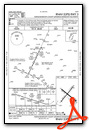
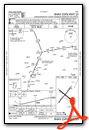
Instrument Approach Procedure (IAP) Charts

Departure Procedure Obstacles (DPO) Charts
Nearby Airports with Instrument Procedures
| ID | Name | Heading / Distance | ||
|---|---|---|---|---|
 |
79D | Philippi/Barbour County Regional Airport | 330° | 19.2 |
|
W22 | Upshur County Regional Airport | 288° | 20.7 |
|
KCKB | North Central West Virginia Airport | 324° | 30.0 |
|
W99 | Grant County Airport | 079° | 33.9 |
|
4G7 | Fairmont Municipal-Frankman Field Airport | 336° | 36.5 |
|
48I | Braxton County Airport | 252° | 39.2 |
|
KMGW | Morgantown Municipal/Walter L Bill Hart Field Airport | 356° | 45.3 |
|
2G4 | Garrett County Airport | 030° | 48.0 |
|
KVBW | Bridgewater Air Park Airport | 126° | 52.6 |
|
8W2 | New Market Airport | 104° | 55.7 |
|
KHSP | Ingalls Field Airport | 178° | 56.2 |
|
KSHD | Shenandoah Valley Regional Airport | 129° | 58.7 |
Airport Images
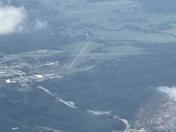
By: Big Orange Bird


