Login
Register


23N
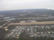
Bayport Aerodrome Airport
Official FAA Data Effective 2024-06-13 0901Z
Chart Supplement

VFR Chart of 23N
Sectional Charts at SkyVector.com
IFR Chart of 23N
Enroute Charts at SkyVector.com
Location Information for 23N
Coordinates: N40°45.46' / W73°3.16'Located 01 miles NW of Bayport, New York on 50 acres of land. View all Airports in New York.
Surveyed Elevation is 39 feet MSL.
Operations Data
|
|
Airport Communications
| UNICOM: | 122.700 |
|---|---|
| CTAF: | 122.700 |
| ASOS at ISP (3.1 NW): | 120.725 631-471-0131 |
| ATIS at ISP (3.2 NW): | 120.725 |
| ASOS at HWV (9.2 NE): | 119.625 631-399-7095 |
Nearby Navigation Aids
|
| ||||||||||||||||||||||||||||||||||||||||||||||||||||||||||||


Runway 18/36
RWY 18/36: WEST 75 FT WIDTH OPEN MAY-SEPT, EAST 75 FT WIDTH OPEN OCT-APR. | ||
| Dimensions: | 2750 x 150 feet / 838 x 46 meters | |
|---|---|---|
| Surface: | Turf in Good Condition | |
| Runway 18 | Runway 36 | |
| Coordinates: | N40°45.68' / W73°3.20' | N40°45.23' / W73°3.12' |
| Elevation: | 38.9 | 31.4 |
| Traffic Pattern: | Right | |
| Displaced Threshold: | 556 Feet RWY 36 THLD MKD WITH 1 FT WIDE APN AND 2 FT WIDE THRD (WHITE) BOTH MADE WITH CONC BLOCKS FLUSH WITH TURF SFC. |
|
| Markings: | Non-Standard in fair condition. | Non-Standard in fair condition. |
| Obstacles: | 52 ft Trees 143 ft from runway, 129 ft right of center RWY 36 CLNC SLOPE 14:1 TO DTHR. |
48 ft Trees 50 ft from runway 12:1 SLP TO DTHR; 54 FT TREES 141 FT FM RWY 97 FT LEFT. |
Services Available
| Fuel: | NONE |
|---|---|
| Transient Storage: | Tiedowns |
| Airframe Repair: | NOT AVAILABLE |
| Engine Repair: | NOT AVAILABLE |
| Bottled Oxygen: | NONE |
| Bulk Oxygen: | NONE |
| Other Services: | PILOT INSTRUCTION |
Ownership Information
| Ownership: | Publicly owned | |
|---|---|---|
| Owner: | TOWN OF ISLIP | |
| 3RD AVE | ||
| BAYPORT, NY 11705 | ||
| 631-467-3300 | ||
| Manager: | SHELLEY LAROSE ARKEN | |
| 100 ARRIVAL AVE, SUITE 100 | ||
| RONKONKOMA, NY 11779 | ||
| 631-467-3300 | ||
Operational Statistics
| Single Engine Aircraft Based on Field: | 37 | Statistics collected for 12 month period ending 2022-08-25 | |
|---|---|---|---|
| Multi-Engine Aircraft Based on Field: | none | Annual Commercial Operations: | none |
| Jet Aircraft Based on Field: | none | Annual Commuter Operations: | none |
| Helicopters Based on Field: | none | Annual Air Taxi Operations: | none |
| Military Aircraft Based on Field: | none | Annual Military Operations: | none |
| Gliders Based on Field: | none | Annual GA Local Operations: | 10000 |
| Ultralights Based on Field: | none | Annual GA Itinerant Operations: | 250 |
Other Remarks
- ALL TFC ENTER 45 DEG LEFT BASE FOR RWY36 AT 600 MSL DUE HEAVY JET TFC RWY 33L AT ISP. ALL TFC ENTER 45 DEG RIGHT. DOWNWIND RWY 18 OVER LAKES AT 600 MSL DUE HEAVY JET TFC LNDG RWY 33L AT ISP.
- ALL DOWNWIND SPACING FOR RWY 18/36 S/B OVER LAKES FOR NOISE ABATEMENT.
- PHONE AT ARPT 631-467-3279.
- NO CLSD TFC PATTERN OR TOUCH AND GO LNDGS.
- ARPT CLSD 30 MIN AFTER SS TIL 30 MIN BEFORE SR.
- PILOTS BE ADVISED: DUE TO PATTERN PROCEDURES, AIRCRAFT IN THE RUN-UP AREA OR STARTING TAKEOFF ROLL ON RY 36, AND AIRCRAFT ON FINAL APPROACH TO RY 36, MAY NOT BE ABLE TO SEE EACH OTHER DUE TO TREES.
- FOR CD CTC NEW YORK APCH AT 516-683-2449.
- RWY 18 THLD MKD WITH CONC BLOCKS FLUSH WITH TURF SFC.
- RWY 36 THLD AND DTHR MKD WITH CONCRETE BLOCKS FLUSH WITH TURF SFC.
Nearby Airports with Instrument Procedures
| ID | Name | Heading / Distance | ||
|---|---|---|---|---|
 |
KISP | Long Island Mac Arthur Airport | 316° | 3.2 |
|
KHWV | Brookhaven Airport | 065° | 9.3 |
|
KFRG | Republic Airport | 264° | 16.5 |
|
KFOK | Francis S Gabreski Airport | 074° | 19.9 |
|
KBDR | Bridgeport/Sikorsky Airport | 352° | 24.6 |
 |
87N | Southampton Heliport | 078° | 27.2 |
|
KHVN | Tweed/New Haven Airport | 013° | 31.3 |
|
KJFK | John F Kennedy International Airport | 258° | 33.9 |
|
KHPN | Westchester County Airport | 302° | 35.1 |
|
KLGA | Laguardia Airport | 272° | 37.4 |
|
KJPX | East Hampton Town Airport | 071° | 38.4 |
|
KDXR | Danbury Municipal Airport | 332° | 41.7 |
Airport Images

By: anelon
By: MGPilot


