Login
Register


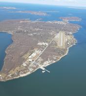
3W2
Put In Bay Airport
Official FAA Data Effective 2026-01-22 0901Z
Chart Supplement

VFR Chart of 3W2
Sectional Charts at SkyVector.com
IFR Chart of 3W2
Enroute Charts at SkyVector.com
Location Information for 3W2
Coordinates: N41°38.20' / W82°49.70'Located 01 miles SW of Put In Bay, Ohio on 38 acres of land. View all Airports in Ohio.
Surveyed Elevation is 595 feet MSL.
Operations Data
|
|
Airport Communications
| CTAF: | 122.800 |
|---|---|
| UNICOM: | 122.800 |
| AWOS-3 at PCW (7.3 S): | 118.775 419-734-9955 |
| AWOS-3P at S24 (22.5 SW): | 119.575 419-547-6932 |
| ASOS at TDZ (29.7 W): | 121.575 419-838-5034 |
Nearby Navigation Aids
|
| ||||||||||||||||||||||||||||||||||||||||||||||||||||||||||||


Runway 03/21
| Dimensions: | 2870 x 75 feet / 875 x 23 meters | |
|---|---|---|
| Surface: | Asphalt in Good Condition | |
| Runway 03 | Runway 21 | |
| Coordinates: | N41°38.00' / W82°49.87' | N41°38.40' / W82°49.53' |
| Elevation: | 592.2 | 594.5 |
| Traffic Pattern: | Right | |
| Displaced Threshold: | 450 Feet | 657 Feet |
| Markings: | Basic in good condition. | Basic in good condition. |
| Obstacles: | 61 ft Trees 402 ft from runway, 119 ft left of center APCH RATIO 13:1 TO DTHR OVR +61 FT TREE, 852 FT DIST, 119 FT L. +0-5 FT FENCE, 200 FT DIST, 125 FT R, EXTDG TO 250 FT FM DTHR, 125 FT R. |
5 ft Fence 201 ft from runway, 120 ft right of center APCH RATIO 15:1 TO DTHR OVR +63 FT TREE, 1158 FT DIST, 68 FT L. +5 FENCE, 0-200 FT DIST, 115 FT L; ALSO +5 FT FENCE, 140-200 FT DIST, 115-125 FT R. |
Services Available
| Fuel: | NONE |
|---|---|
| Transient Storage: | Hangars,Tiedowns PRIOR CDN RQRD. |
| Airframe Repair: | MAJOR |
| Engine Repair: | MAJOR |
| Bottled Oxygen: | NONE |
| Bulk Oxygen: | NONE |
| Other Services: | CHARTER SERVICE |
Ownership Information
| Ownership: | Publicly owned | |
|---|---|---|
| Owner: | PUT IN BAY TOWNSHIP PORT AUTH | |
| PO BOX 278 | ||
| PUT IN BAY, OH 43456-0278 | ||
| 419-285-3371 | ||
| Manager: | BETH FURNER | |
| 1494 LANGRAM RD | ||
| PUT IN BAY, OH 43456-6721 | ||
| 419-285-3371 | ||
Other Remarks
- THIS AIRPORT HAS BEEN SURVEYED BY THE NATIONAL GEODETIC SURVEY.
- FOR CD CTC CLEVELAND APCH AT 216-352-2323.
- EXP MOD TURB ON APCH/DEP WHEN WIND EXCEEDS 10 KT.
- ACFT LDG RWY 21 OR DEP RWY 03 RMN 1000 FT CLEAR OF PERRY'S MONUMENT 352 FT AGL (942 FT MSL) 1.3 NM NE OF ARPT.
- ACFT OPS PROHIBITED DUSK-DAWN.
- HELIPAD IS FOR TOUCHDOWN, LOADING, & LIFTOFF ONLY - PARK ON GRASS WEST & SW OF HELIPAD.
- BIRDS, DEER, & OTR WILDLIFE INVOF ARPT.
- ROPES NOT PRVDD.
Nearby Airports with Instrument Procedures
| ID | Name | Heading / Distance | ||
|---|---|---|---|---|
 |
KPCW | Erie-Ottawa International Airport | 194° | 7.5 |
|
S24 | Sandusky County Regional Airport | 204° | 22.5 |
|
14G | Fremont Airport | 219° | 23.6 |
|
5A1 | Norwalk/Huron County Airport | 151° | 26.6 |
|
KTDZ | Toledo Exec Airport | 261° | 29.7 |
|
KONZ | Grosse Ile Municipal Airport | 331° | 31.5 |
|
KTTF | Custer Airport | 303° | 32.7 |
|
KLPR | Lorain County Regional Airport | 120° | 34.2 |
|
8G1 | Willard Airport | 172° | 36.2 |
|
16G | Seneca County Airport | 208° | 36.9 |
|
KFZI | Donald P Miller Airport | 223° | 36.9 |
|
1G1 | Elyria Airport | 118° | 37.6 |