Login
Register


4G3
Miller Airport
Official FAA Data Effective 2025-12-25 0901Z
Chart Supplement

VFR Chart of 4G3
Sectional Charts at SkyVector.com
IFR Chart of 4G3
Enroute Charts at SkyVector.com
Location Information for 4G3
Coordinates: N40°58.90' / W81°2.53'Located 05 miles NE of Alliance, Ohio on 225 acres of land. View all Airports in Ohio.
Surveyed Elevation is 1071 feet MSL.
Operations Data
|
|
Airport Communications
| CLEVELAND APPROACH: | 125.5 371.875 |
|---|---|
| CLEVELAND DEPARTURE: | 125.5 371.875 |
| CTAF: | 122.900 |
| AWOS-3 at POV (16.5 NW): | 118.675 330-298-9353 |
| ATIS at CAK (18.6 W): | 121.05 |
| ASOS at CAK (18.6 W): | 330-227-8682 |
- APCH/DEP SVC PRVDD BY CLEVELAND APCH (CLE) 0600-0100. APCH/DEP SVC PRVDD BY CLEVELAND ARTCC (ZOB) ON FREQS 120.6/379.275 (MOUNT HOPE RCAG) 0100-0600.
Nearby Navigation Aids
|
| ||||||||||||||||||||||||||||||||||||||||||||||||||||||||||||


Runway 09/27
| Dimensions: | 2912 x 50 feet / 888 x 15 meters | |
|---|---|---|
| Surface: | Asphalt in Fair Condition | |
| Weight Limits: | S-9 | |
| Runway 09 | Runway 27 | |
| Coordinates: | N40°58.91' / W81°2.84' | N40°58.90' / W81°2.21' |
| Elevation: | 1056.4 | 1067.1 |
| Traffic Pattern: | Left | Left |
| Runway Heading: | 91° True | 271° True |
| Markings: | Basic in poor condition. | Basic in poor condition. |
| Obstacles: | 110 ft Trees 1000 ft from runway, 165 ft right of center +35 FT TREES, 201 FT DIST, 120 FT R. 8 FT CROPS, 60 FT DIST, 125 FT L/R; 65 FT TREES, 0-55 FT DIST, 110 FT R; 35 FT TREE, 55 FT DIST, 125 FT L. |
35 ft Trees 201 ft from runway, 120 ft right of center 60 FT TREES, 132 FT DIST, 120 FT R. |
Services Available
| Fuel: | NONE |
|---|---|
| Transient Storage: | Tiedowns |
| Airframe Repair: | NOT AVAILABLE |
| Engine Repair: | NOT AVAILABLE |
| Bottled Oxygen: | NONE |
| Bulk Oxygen: | NONE |
Ownership Information
| Ownership: | Privately Owned | |
|---|---|---|
| Owner: | GROVER MATTHEWS | |
| 1286 ADAMS ST | ||
| FAIRBORN, OH 45324-5505 | ||
| 270-863-1799 | ||
| Manager: | GROVER MATTHEWS | GCMLLM1963@GMAIL.COM. |
| 1286 ADAMS ST | ARPT PHYS ADS: 20388 N BENTON WEST RD, NORTH BENTON, OH 44449-9636. | |
| FAIRBORN, OH 45324-5505 | ||
| 270-863-1799 | ||
Other Remarks
- THIS AIRPORT HAS BEEN SURVEYED BY THE NATIONAL GEODETIC SURVEY.
- DAYTIME OPS ONLY.
- FOR CD CTC CLEVELAND APCH AT 216-352-2323, WHEN APCH CLSD CTC CLEVELAND ARTCC AT 440-774-0223/0490.
- DEER, BIRDS, & WILDLIFE ON & INVOF ARPT.
- (ARPT STATUS) ARPT CLSD INDEFLY.
- FADED.
- FADED.
Nearby Airports with Instrument Procedures
| ID | Name | Heading / Distance | ||
|---|---|---|---|---|
 |
3G6 | Tri-City Airport | 157° | 4.9 |
|
38D | Salem Airpark Airport | 103° | 8.4 |
|
4G4 | Youngstown Elser Metro Airport | 094° | 16.6 |
|
KPOV | Portage County Airport | 325° | 16.7 |
|
KCAK | Akron-Canton Regional Airport | 257° | 18.7 |
|
KAKR | Akron Fulton International Airport | 279° | 19.6 |
|
1G3 | Kent State University Airport | 301° | 19.7 |
|
KYNG | Youngstown/Warren Regional Airport | 044° | 23.5 |
|
KTSO | Carroll County/Tolson Airport | 183° | 25.2 |
|
02G | Columbiana County Airport | 135° | 26.0 |
|
7G8 | Geauga County Airport | 358° | 28.1 |
|
KUCP | New Castle Municipal Airport | 084° | 28.7 |
Airport Images
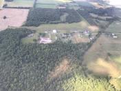
By: btracy62


