Login
Register


89D
Kelleys Island Land Field Airport
Official FAA Data Effective 2026-01-22 0901Z
Chart Supplement

VFR Chart of 89D
Sectional Charts at SkyVector.com
IFR Chart of 89D
Enroute Charts at SkyVector.com
Location Information for 89D
Coordinates: N41°36.19' / W82°41.10'Located 01 miles NE of Kelleys Island, Ohio on 32 acres of land. View all Airports in Ohio.
Surveyed Elevation is 598 feet MSL.
Operations Data
|
|
Airport Communications
| CTAF: | 122.900 |
|---|---|
| AWOS-3 at PCW (9.7 SW): | 118.775 419-734-9955 |
| AWOS-3P at S24 (24.3 SW): | 119.575 419-547-6932 |
| ASOS at LPR (27.5 SE): | 118.925 440-323-7088 |
Nearby Navigation Aids
|
| ||||||||||||||||||||||||||||||||||||||||||||||||||||||||||||


Runway 09/27
| Dimensions: | 2202 x 50 feet / 671 x 15 meters | |
|---|---|---|
| Surface: | Asphalt in Good Condition | |
| Edge Lighting: | Medium Intensity | |
| Runway 09 | Runway 27 | |
| Coordinates: | N41°36.20' / W82°41.34' | N41°36.18' / W82°40.86' |
| Elevation: | 598.2 | 578.9 |
| Traffic Pattern: | Left | Left |
| Runway Heading: | 92° True | 272° True |
| Displaced Threshold: | 200 Feet | |
| Markings: | Basic in good condition. | Basic in good condition. |
| Obstacles: | 55 ft Trees 329 ft from runway, 180 ft right of center APCH SLP 7:1 TO DTHR DUE TO +54 FT TREE, 594 FT DIST, 139 FT R. 10 FT ROAD, 12 FT DIST, 125 FT L/R. |
70 ft Fence 286 ft from runway, 129 ft right of center +10 FT ROAD, 0-92 FT DIST, 0-125 FT L; +4 FT PROPANE TANK, 104-120 FT DIST, 87-92 FT L; +18 FT HOUSE, 102-200 FT DIST, 94-125 FT L; +12 FT TREES, 106-136 FT DIST, 80 FT L. |
Services Available
| Fuel: | NONE |
|---|---|
| Transient Storage: | Tiedowns |
| Airframe Repair: | NONE |
| Engine Repair: | NONE |
| Bottled Oxygen: | NONE |
| Bulk Oxygen: | NONE |
Ownership Information
| Ownership: | Publicly owned | |
|---|---|---|
| Owner: | VILLAGE OF KELLEYS ISLAND | |
| 121 ADDISON ST BOX 469 | ||
| KELLEYS ISLAND, OH 43438 | ||
| 419-746-2535 | UNMON ARPT TRML 419-746-2228. | |
| Manager: | ROBERT QUINN | |
| 121 ADDISON ST BOX 469 | ||
| KELLEYS ISLAND, OH 43438 | ||
| 419-503-0663 | ||
Other Remarks
- DEER & BIRDS ON & INVOF ARPT.
- FOR CD CTC CLEVELAND APCH AT 216-352-2323.
- ACTVT MIRL RWY 09/27 - CTAF.
Nearby Airports with Instrument Procedures
| ID | Name | Heading / Distance | ||
|---|---|---|---|---|
 |
KPCW | Erie-Ottawa International Airport | 237° | 9.8 |
|
5A1 | Norwalk/Huron County Airport | 164° | 22.3 |
|
S24 | Sandusky County Regional Airport | 220° | 24.3 |
|
14G | Fremont Airport | 233° | 26.9 |
|
KLPR | Lorain County Regional Airport | 123° | 27.7 |
|
1G1 | Elyria Airport | 121° | 31.0 |
|
8G1 | Willard Airport | 183° | 33.9 |
|
KTDZ | Toledo Exec Airport | 266° | 36.0 |
|
KONZ | Grosse Ile Municipal Airport | 324° | 36.6 |
|
16G | Seneca County Airport | 218° | 38.7 |
|
KCLE | Cleveland-Hopkins International Airport | 106° | 39.2 |
|
KTTF | Custer Airport | 301° | 39.2 |
Airport Images
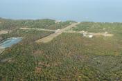
By: TomD


