Login
Register


H66
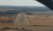
Nowata Municipal Airport
Official FAA Data Effective 2026-02-19 0901Z
Chart Supplement

VFR Chart of H66
Sectional Charts at SkyVector.com
IFR Chart of H66
Enroute Charts at SkyVector.com
Location Information for H66
Coordinates: N36°43.26' / W95°37.52'Located 02 miles NE of Nowata, Oklahoma on 100 acres of land. View all Airports in Oklahoma.
Surveyed Elevation is 679 feet MSL.
Operations Data
|
|
Airport Communications
| CTAF: | 122.900 |
|---|---|
| ASOS at BVO (18.7 W): | 132.675 918-336-2070 |
| ASOS at CFV (22.5 N): | 121.275 620-251-1959 |
| AWOS-3PT at GCM (26.7 S): | 119.925 918-343-0184 |
Nearby Navigation Aids
|
| ||||||||||||||||||||||||||||||||||||||||||||||||||||||||||||


Runway 17/35
| Dimensions: | 2500 x 45 feet / 762 x 14 meters | |
|---|---|---|
| Surface: | Asphalt in Good Condition | |
| Weight Limits: | S-4 | |
| Runway 17 | Runway 35 | |
| Traffic Pattern: | Left | Left |
| Markings: | None | None |
| Obstacles: | 20 ft Trees 599 ft from runway | 24 ft Trees 267 ft from runway, 82 ft left of center 20 FT TREES AT RWY END 110 FT LEFT AND RIGHT OF CENTERLINE. |
Runway 05/23
RWY 05/23 CLSD INDEFLY, UNUSBL. | ||
| Dimensions: | 2440 x 45 feet / 744 x 14 meters | |
|---|---|---|
| Surface: | Turf in Failed Condition RWY UNIDENTIFIABLE; PLINE AND ROAD CROSS RWY. RWY EXTREMELY ROUGH & COVERED WITH TALL GRASS & HAY BALES. RWY UNUSBL. | |
| Runway 05 | Runway 23 | |
| Traffic Pattern: | Left | Left |
| Obstacles: | 40 ft Power Line 325 ft from runway | 40 ft Trees 700 ft from runway |
Services Available
| Fuel: | NONE |
|---|---|
| Transient Storage: | NONE |
| Airframe Repair: | NONE |
| Engine Repair: | NONE |
| Bottled Oxygen: | NONE |
| Bulk Oxygen: | NONE |
Ownership Information
| Ownership: | Publicly owned | |
|---|---|---|
| Owner: | CITY OF NOWATA | |
| 114 S MAPLE ST | ||
| NOWATA, OK 74048 | ||
| 918-273-3538 | ||
| Manager: | MELANIE COLLINS | CITY MANAGER. |
| 114 S MAPLE ST | ||
| NOWATA, OK 74048 | ||
| (918) 273-3538 | ||
Other Remarks
- -2 FT DITCH AT RY 23 THLD; -12 FT DITCH 220 FT FM RY 35 THLD.
- FOR CD CTC KANSAS CITY ARTCC AT 913-254-8508.
- CONNECTOR TWY AND APRON PVMT FAILED.
Nearby Airports with Instrument Procedures
| ID | Name | Heading / Distance | ||
|---|---|---|---|---|
 |
KBVO | Bartlesville Municipal Airport | 277° | 18.8 |
|
KCFV | Coffeyville Municipal Airport | 006° | 22.5 |
|
H04 | Vinita Municipal Airport | 105° | 23.7 |
|
KGCM | Claremore Regional Airport | 164° | 26.6 |
|
KIDP | Independence Municipal Airport | 344° | 27.2 |
|
1K8 | South Grand Lake Regional Airport | 109° | 31.3 |
|
H71 | Mid-America Industrial Airport | 154° | 32.9 |
|
KTUL | Tulsa International Airport | 202° | 33.8 |
|
KPPF | Tri-City Airport | 008° | 37.0 |
|
KMIO | Miami Regional Airport | 072° | 37.3 |
|
KOWP | William R Pogue Municipal Airport | 218° | 41.5 |
|
2K7 | Neodesha Municipal Airport | 358° | 42.8 |
Airport Images

By: Big Orange Bird
By: KBurkhardt


