Login
Register


ASX
John F Kennedy Memorial Airport
Official FAA Data Effective 2026-01-22 0901Z
Chart Supplement

VFR Chart of KASX
Sectional Charts at SkyVector.com
IFR Chart of KASX
Enroute Charts at SkyVector.com
Location Information for KASX
Coordinates: N46°32.91' / W90°55.14'Located 02 miles SW of Ashland, Wisconsin on 511 acres of land. View all Airports in Wisconsin.
Surveyed Elevation is 826 feet MSL.
Operations Data
|
|
Airport Communications
| ASOS: | 126.775 Tel. 715-682-5541 |
|---|---|
| UNICOM: | 122.800 |
| CTAF: | 122.800 |
| AWOS-3PT at 4R5 (15.9 NE): | 119.375 715-747-5519 |
| AWOS-3PT at IWD (32.6 E): | 125.175 906-932-4039 |
| ASOS at HYR (37.9 SW): | 118.4 715-634-6138 |
- APCH/DEP SVC PRVDD BY MINNEAPOLIS ARTCC ON FREQS 126.45/276.4(HAYWARD RCAG).
Nearby Navigation Aids
|
| ||||||||||||||||||||||||||||||||||||||||||||||||||||||


Runway 02/20
| Dimensions: | 5197 x 100 feet / 1584 x 30 meters | |
|---|---|---|
| Surface: | Asphalt in Excellent Condition | |
| Weight Limits: | S-40, D-56
PCR VALUE: 160/F/D/X/T
| |
| Edge Lighting: | Medium Intensity | |
| Runway 02 | Runway 20 | |
| Coordinates: | N46°32.43' / W90°55.48' | N46°33.23' / W90°55.04' |
| Elevation: | 818.9 | 823.2 |
| Traffic Pattern: | Left | Left |
| Runway Heading: | 21° True | 201° True |
| Markings: | Non-Precision Instrument in good condition. | Non-Precision Instrument in good condition. |
| Glide Slope Indicator | P4L (3.00° Glide Path Angle) | P4R (3.00° Glide Path Angle) |
| REIL: | Yes | Yes |
| Obstacles: | 69 ft Trees 2215 ft from runway, 520 ft right of center | |
Runway 13/31
| Dimensions: | 3498 x 75 feet / 1066 x 23 meters | |
|---|---|---|
| Surface: | Asphalt in Fair Condition | |
| Weight Limits: | S-40, D-50 | |
| Edge Lighting: | Medium Intensity | |
| Runway 13 | Runway 31 | |
| Coordinates: | N46°33.22' / W90°55.28' | N46°32.84' / W90°54.64' |
| Elevation: | 824.1 | 809.9 |
| Traffic Pattern: | Left | Left |
| Runway Heading: | 131° True | 311° True |
| Markings: | Non-Precision Instrument in good condition. | Non-Precision Instrument in good condition. |
| Glide Slope Indicator | P2L (3.00° Glide Path Angle) | |
| Obstacles: | 8 ft Fence 200 ft from runway, 220 ft right of center CTLNG OBSTN EXCEEDS A 45 DEG SLP. |
49 ft Trees 1135 ft from runway, 340 ft right of center |
Services Available
| Fuel: | 100LL (blue), Jet A+ |
|---|---|
| Transient Storage: | Hangars,Tiedowns |
| Airframe Repair: | NONE |
| Engine Repair: | NONE |
| Bottled Oxygen: | NONE |
| Bulk Oxygen: | NONE |
| Other Services: | PILOT INSTRUCTION |
Ownership Information
| Ownership: | Publicly owned | |
|---|---|---|
| Owner: | COUNTY & CITY OF ASHLAND | |
| 601 MAIN STREET WEST | ||
| ASHLAND, WI 54806 | ||
| 715-682-7071 | ||
| Manager: | DEREK HALL | |
| 50511 STATE HIGHWAY 112 | ||
| ASHLAND, WI 54806 | ||
| 715-682-7070 | ||
Other Remarks
- THIS AIRPORT HAS BEEN SURVEYED BY THE NATIONAL GEODETIC SURVEY.
- DEER & OTR WILDLIFE ON & INVOF ARPT. HVY BIRD ACT SPRING & SUMMER MONTHS.
- ACFT OVER 4000 LBS MUST STOP OR PARK ON CONC; ALL OTR ACFT PARK ON ASPH.
- GCO AVBL ON FREQ 122.25 THRU FLT SVCS.
- FOR CD IF UNA TO CTC ON FSS FREQ, CTC MINNEAPOLIS ARTCC AT 651-463-5588.
- 0LL JET A+ PPR CTC AMGR 715-682-7070, AFT HRS CALL 715-292-7070. 24 HR SELF SERVE 100LL.
- MIRL RWY 02/20 PRESET TO LOW SS-SR; TO INCR INTST AND ACTVT REIL RWY 02 & 20; PAPI RWY 02, 20, & 31; MIRL RWY 02/20 & 13/31 - CTAF.
Weather Minimums


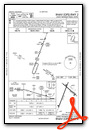
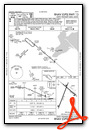
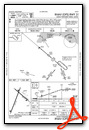
Instrument Approach Procedure (IAP) Charts


Nearby Airports with Instrument Procedures
| ID | Name | Heading / Distance | ||
|---|---|---|---|---|
 |
4R5 | Major Gilbert Field Airport | 024° | 15.9 |
|
3CU | Cable Union Airport | 212° | 25.3 |
|
KIWD | Gogebic/Iron County Airport | 091° | 32.6 |
|
KHYR | Sawyer County Airport | 215° | 38.3 |
|
KOLG | Solon Springs Municipal Airport | 249° | 39.8 |
|
KPKF | Park Falls Municipal Airport | 149° | 41.1 |
|
KTWM | Richard B Helgeson Airport | 311° | 45.4 |
|
KDYT | Sky Harbor Airport | 283° | 47.7 |
|
KSUW | Richard I Bong Airport | 280° | 49.4 |
|
D25 | Manitowish Waters Airport | 120° | 50.2 |
|
KPBH | Price County Airport | 156° | 54.8 |
|
KDLH | Duluth International Airport | 288° | 55.5 |
Airport Images
Do you have a recent image of this airport? Upload it here!


