Login
Register


LNP
Lonesome Pine Airport
Official FAA Data Effective 2026-02-19 0901Z
Chart Supplement

VFR Chart of KLNP
Sectional Charts at SkyVector.com
IFR Chart of KLNP
Enroute Charts at SkyVector.com
Location Information for KLNP
Coordinates: N36°59.26' / W82°31.79'Located 03 miles NE of Wise, Virginia on 417 acres of land. View all Airports in Virginia.
Surveyed Elevation is 2684 feet MSL.
Operations Data
|
|
Airport Communications
| AWOS-3: | 118.6 Tel. 276-328-3727 |
|---|---|
| UNICOM: | 123.000 |
| CTAF: | 123.000 |
| AWOS-3 at VJI (29.8 SE): | 128.125 276-628-2940 |
| ASOS at TRI (31.1 S): | 118.25 423-218-2712 |
| ATIS at TRI (31.3 S): | 118.25 |
- APCH/DEP SVC PRVDD BY INDIANAPOLIS ARTCC ON FREQS 126.575/257.85 (BLUEFIELD RCAG).
Nearby Navigation Aids
|
| ||||||||||||||||||||||||||||||||||||||||||||||||||||||||||||


Runway 06/24
| Dimensions: | 5131 x 100 feet / 1564 x 30 meters | |
|---|---|---|
| Surface: | Asphalt in Excellent Condition | |
| Weight Limits: | S-42, D-55, ST-100 | |
| Edge Lighting: | Medium Intensity | |
| Runway 06 | Runway 24 | |
| Coordinates: | N36°59.02' / W82°32.22' | N36°59.49' / W82°31.35' |
| Elevation: | 2668.9 | 2684.8 |
| Traffic Pattern: | Left | Left |
| Runway Heading: | 56° True | 236° True |
| Markings: | Non-Precision Instrument in good condition. | Non-Precision Instrument in good condition. |
| Glide Slope Indicator | P4L (3.00° Glide Path Angle) | P4R (3.00° Glide Path Angle) |
| Approach Lights: | ODALS Omnidirectional Approach Lighting System NSTD ODALS; 3 LGT CONFIGN. | |
| REIL: | Yes | |
| Obstacles: | 54 ft Trees 1185 ft from runway, 240 ft right of center | 38 ft Tree 926 ft from runway, 350 ft left of center |
Services Available
| Fuel: | 100LL (blue), Jet A+ |
|---|---|
| Transient Storage: | Hangars,Tiedowns |
| Airframe Repair: | NOT AVAILABLE |
| Engine Repair: | NOT AVAILABLE |
| Bottled Oxygen: | NONE |
| Bulk Oxygen: | NONE |
| Other Services: | PILOT INSTRUCTION,AIRCRAFT RENTAL,ANNUAL SURVEYING |
Ownership Information
| Ownership: | Publicly owned | |
|---|---|---|
| Owner: | THE CUMBERLAND ARPT COMSN | DONNIE ROSE, CHAIRMAN. |
| 6225 AIRPORT ROAD | ||
| WISE, VA 24293 | ||
| 276-328-5300 | ||
| Manager: | JOSEPH TEAGUE | |
| 6225 AIRPORT RD. | ||
| WISE, VA 24293 | ||
| 276-328-5300 | AFT HRS CTC 276-455-4481 OR 276-219-9807. | |
Other Remarks
- WILDLIFE ON/INVOF AIRPORT.
- UNATTENDED SUNDAY.
- FOR CD CTC INDIANAPOLIS ARTCC AT 317-247-2411.
- ACTVT ODALS RWY 24; REIL RWY 06; MIRL 06/24 - CTAF.
Weather Minimums

Instrument Approach Procedure (IAP) Charts
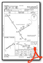


Nearby Airports with Instrument Procedures
| ID | Name | Heading / Distance | ||
|---|---|---|---|---|
 |
KVJI | Virginia Highlands Airport | 126° | 29.9 |
|
KTRI | Tri-Cities Airport | 169° | 31.3 |
|
KPBX | Pike County/Hatcher Field Airport | 357° | 34.5 |
|
KJFZ | Tazewell County Airport | 082° | 35.4 |
|
KRVN | Hawkins County Airport | 208° | 36.1 |
|
0VG | Lee County Airport | 239° | 38.7 |
|
I35 | Tucker-Guthrie Memorial Airport | 259° | 40.6 |
|
0A9 | William B Greene Jr Regional Airport | 154° | 40.7 |
|
KCPF | Wendell H Ford Airport | 304° | 42.5 |
|
KEBD | Southern West Virginia Regional Airport | 025° | 45.9 |
|
KSJS | Big Sandy Regional Airport | 353° | 46.0 |
|
6A4 | Johnson County Airport | 134° | 48.2 |
Airport Images
Do you have a recent image of this airport? Upload it here!


