Login
Register


LOU
Bowman Field Airport
Official FAA Data Effective 2026-02-19 0901Z
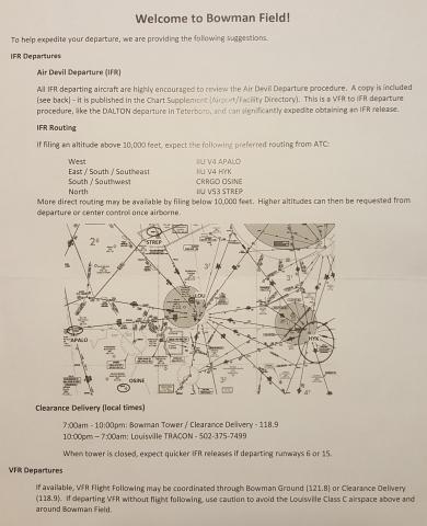
From the Flight Deck
Chart Supplement

KLOU Airport Diagram

VFR Chart of KLOU
Sectional Charts at SkyVector.com
IFR Chart of KLOU
Enroute Charts at SkyVector.com
Location Information for KLOU
Coordinates: N38°13.68' / W85°39.82'Located 05 miles SE of Louisville, Kentucky on 426 acres of land. View all Airports in Kentucky.
Surveyed Elevation is 545 feet MSL.
Operations Data
|
|
Airport Communications
| ATIS: | 124.15 |
|---|---|
| ASOS: | Tel. 502-473-0693 |
| BOWMAN TOWER: | 119.5 257.625 |
| BOWMAN GROUND: | 121.8 |
| LOUISVILLE APPROACH: | 132.075 327.0 |
| LOUISVILLE DEPARTURE: | 132.075 327.0 |
| CLEARANCE DELIVERY: | 118.9 |
| UNICOM: | 122.950 |
| VFR ADZY: | 119.5 |
| CTAF: | 119.500 |
| ASOS at SDF (4.4 SW): | 502-676-6814 |
| D-ATIS at SDF (4.7 SW): | 118.725 |
| AWOS-3 at JVY (9.4 N): | 118.575 812-246-1278 |
Nearby Navigation Aids
|
| ||||||||||||||||||||||||||||||||||||||||||||||||||||||||||||


Runway 06/24
| Dimensions: | 4358 x 75 feet / 1328 x 23 meters | |
|---|---|---|
| Surface: | Asphalt in Fair Condition | |
| Weight Limits: | S-30 | |
| Edge Lighting: | Medium Intensity | |
| Runway 06 | Runway 24 | |
| Coordinates: | N38°13.53' / W85°40.17' | N38°13.89' / W85°39.38' |
| Elevation: | 544.4 | 530.8 |
| Traffic Pattern: | Left | Left |
| Runway Heading: | 60° True | 240° True |
| Displaced Threshold: | 848 Feet | 310 Feet |
| Declared Distances: | TORA:4047 TODA:4357 ASDA:4316 LDA:3469 | TORA:3509 TODA:4357 ASDA:4165 LDA:3856 |
| Markings: | Non-Precision Instrument in good condition. | Non-Precision Instrument in good condition. |
| Glide Slope Indicator | P2L (3.50° Glide Path Angle) | P2L (3.00° Glide Path Angle) |
| REIL: | Yes | |
| Obstacles: | 10 ft Tree 204 ft from runway, 76 ft right of center APCH RATIO 20:1 TO DTHR. 8 FT FENCE 108 FT FM RWY END; 956 FT FM DTHR. ROAD 159 FT FM RWY END; 1007 FT FM DTHR. |
17 ft Tree 388 ft from runway, 80 ft left of center APCH RATIO 20:1 TO DTHR. |
Runway 15/33
| Dimensions: | 3580 x 75 feet / 1091 x 23 meters | |
|---|---|---|
| Surface: | Asphalt in Fair Condition | |
| Weight Limits: | S-30 | |
| Edge Lighting: | Medium Intensity | |
| Runway 15 | Runway 33 | |
| Coordinates: | N38°13.88' / W85°40.11' | N38°13.41' / W85°39.66' |
| Elevation: | 538.6 | 518.7 |
| Traffic Pattern: | Left | Left |
| Runway Heading: | 144° True | 324° True |
| Displaced Threshold: | 206 Feet | 342 Feet |
| Declared Distances: | TORA:3238 TODA:3579 ASDA:3579 LDA:3373 | TORA:3373 TODA:3579 ASDA:3466 LDA:3125 |
| Markings: | Non-Precision Instrument in good condition. | Non-Precision Instrument in good condition. |
| Glide Slope Indicator | P2L (3.50° Glide Path Angle) | P2L (3.25° Glide Path Angle) |
| REIL: | Yes | |
| Obstacles: | 7 ft Other 262 ft from runway, 214 ft left of center 6 FT PATH & GOLF CARTS. APCH RATIO 20:1 TO DTHR. +8 FT FENCE 188 FT FM RWY END; 394 FT FM DTHR. |
8 ft Road 289 ft from runway, 263 ft left of center APCH RATIO 20:1 TO DTHR. |
Services Available
| Fuel: | 100LL (blue), Jet-A |
|---|---|
| Transient Storage: | Hangars,Tiedowns |
| Airframe Repair: | MAJOR |
| Engine Repair: | MAJOR |
| Bottled Oxygen: | HIGH/LOW |
| Bulk Oxygen: | HIGH/LOW |
| Other Services: | AIR AMBULANCE SERVICES,AVIONICS,CHARTER SERVICE,PILOT INSTRUCTION,AIRCRAFT RENTAL,AIRCRAFT SALES |
Ownership Information
| Ownership: | Publicly owned | |
|---|---|---|
| Owner: | REGIONAL AIRPORT AUTH | |
| P O BOX 9129 | ||
| LOUISVILLE, KY 40209-0129 | ||
| 502-368-6524 | ||
| Manager: | JORGIE DERMODY | |
| 3345 ROGER E SCHUPP STREET | ||
| LOUISVILLE, KY 40205 | ||
| 502-243-7305 | 502-851-5903 | |
Other Remarks
- COMPASS ROSE LCTD AT ADMIN BLDG NOT FOR COMPASS CALIBRATION USE.
- 24 HR PPR FOR MIL ROTARY WING.
- FOR CD WHEN ATCT CLSD, CTC SDF ATCT 502-375-7499.
- NOISE ABATEMENT: NO PRACTICE APCH MON-SAT 2200-0700. SUN 2200-0900, OR WHEN TWR CLSD.
- STAGE 3 COMPLIANCE RQRD FOR TURBOJET; PPR OVR 30000 LB GWT - AMGR.
- TRNG OPS NA WHEN ATCT CLSD.
- OBSTNS & TREES IN ALL APCH SFCS.
- ADCUS FLT NOTIFICATION SVC AVBL.
- BIRDS ON & INVOF ARPT DURG DALGT HR.
- ACTVT MIRL RWY 06/24 & 15/33 - CTAF.
Weather Minimums

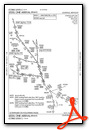
Standard Terminal Arrival (STAR) Charts


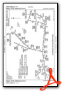

Instrument Approach Procedure (IAP) Charts

Nearby Airports with Instrument Procedures
| ID | Name | Heading / Distance | ||
|---|---|---|---|---|
 |
KSDF | Louisville Muhammad Ali International Airport | 226° | 4.7 |
|
KJVY | Clark Regional Airport | 337° | 9.0 |
|
KFTK | Godman AAF Airport | 217° | 24.2 |
|
KBRY | Samuels Field Airport | 162° | 26.0 |
|
KIMS | Madison Regional Airport | 016° | 33.2 |
|
KEKX | Addington Field Airport | 200° | 34.8 |
|
KFFT | Capital City Airport | 094° | 35.9 |
|
6I2 | Lebanon Springfield/George Hoerter Field Airport | 150° | 40.9 |
|
KSER | Freeman Municipal Airport | 344° | 43.3 |
|
I93 | Breckinridge County Airport | 234° | 45.4 |
|
KFRH | French Lick Municipal Airport | 290° | 48.9 |
|
KOVO | North Vernon Airport | 003° | 49.1 |


Comments
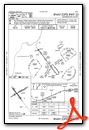
Air Devil dept
The FBO is located next to nmbrs of RY6 (West Ramp), not across from TY A3 (I think that's a flight school). Departures (IFR & VFR) should expect the "Air Devil Dept", see jpg.
william beebe
Pages