Login
Register


PNT
Pontiac Municipal Airport
Official FAA Data Effective 2026-01-22 0901Z
Chart Supplement

VFR Chart of KPNT
Sectional Charts at SkyVector.com
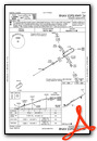
IFR Chart of KPNT
Enroute Charts at SkyVector.com
Location Information for KPNT
Coordinates: N40°55.47' / W88°37.44'Located 03 miles N of Pontiac, Illinois on 311 acres of land. View all Airports in Illinois.
Surveyed Elevation is 666 feet MSL.
Operations Data
|
|
Airport Communications
| AWOS-3: | 119.675 Tel. 815-844-0923 |
|---|---|
| UNICOM: | 123.075 |
| CTAF: | 123.075 |
| AWOS-3PT at BMI (30.0 SW): | 135.35 309-661-9478 |
| ATIS at BMI (30.0 SW): | 119.575 |
| AWOS-3 at C09 (31.4 N): | 118.175 815-941-1815 |
- APCH/DEP SVC PRVDD BY CHICAGO ARTCC (ZAU) ON FREQS 123.75/259.1 (MAZON RCAG).
Nearby Navigation Aids
|
| ||||||||||||||||||||||||||||||||||||||||||||||||||||||||||||


Runway 06/24
| Dimensions: | 5000 x 75 feet / 1524 x 23 meters | |
|---|---|---|
| Surface: | Asphalt in Good Condition | |
| Weight Limits: | S-30, D-30 | |
| Edge Lighting: | Medium Intensity | |
| Runway 06 | Runway 24 | |
| Coordinates: | N40°55.25' / W88°37.90' | N40°55.68' / W88°36.97' |
| Elevation: | 648.8 | 666.2 |
| Runway Heading: | 59° True | 239° True |
| Markings: | Non-Precision Instrument in good condition. | Non-Precision Instrument in good condition. |
| Glide Slope Indicator | P4L (3.00° Glide Path Angle) | P4L (3.00° Glide Path Angle) |
Services Available
| Fuel: | 100LL (blue), Jet-A |
|---|---|
| Transient Storage: | Tiedowns |
| Airframe Repair: | MAJOR |
| Engine Repair: | MAJOR |
| Bottled Oxygen: | NOT AVAILABLE |
| Bulk Oxygen: | NOT AVAILABLE |
| Other Services: | CROP DUSTING SERVICES,PILOT INSTRUCTION |
Ownership Information
| Ownership: | Publicly owned | |
|---|---|---|
| Owner: | CITY OF PONTIAC | |
| CITY HALL - 115 W. HOWARD | ||
| PONTIAC, IL 61764 | ||
| 815-844-3396 | ||
| Manager: | SARAH PETERSEN | |
| CITY HALL - 115 W. HOWARD | ||
| PONTIAC, IL 61764 | ||
| 815-844-2707 | ||
Other Remarks
- ACTVT PAPI RWY 06 & 24 & MIRL RWY 06/24 - CTAF.
Weather Minimums


Instrument Approach Procedure (IAP) Charts

Nearby Airports with Instrument Procedures
| ID | Name | Heading / Distance | ||
|---|---|---|---|---|
 |
KBMI | Central Il Regional/Bloomington-Normal Airport | 206° | 29.9 |
|
C09 | Morris Municipal/James R Washburn Field Airport | 017° | 31.4 |
|
C75 | Marshall County Airport | 279° | 35.1 |
|
KVYS | Illinois Valley Regional-Walter A Duncan Field Airport | 316° | 35.0 |
|
KIKK | Greater Kankakee Airport | 075° | 36.4 |
|
1C1 | Paxton Airport | 141° | 36.4 |
|
KTIP | Rantoul Ntl Avn Cntr-Frank Elliott Field Airport | 149° | 43.8 |
|
3MY | Mount Hawley Auxiliary Airport | 260° | 45.7 |
|
KLOT | Lewis University Airport | 030° | 47.4 |
|
C16 | Frasca Field Airport | 157° | 50.5 |
|
C56 | Bult Field Airport | 057° | 50.7 |
|
KPIA | General Downing - Peoria International Airport | 252° | 51.2 |
Airport Images
Do you have a recent image of this airport? Upload it here!


