Login
Register


STE
Stevens Point Municipal Airport
Official FAA Data Effective 2026-01-22 0901Z
Chart Supplement

VFR Chart of KSTE
Sectional Charts at SkyVector.com
IFR Chart of KSTE
Enroute Charts at SkyVector.com
Location Information for KSTE
Coordinates: N44°32.71' / W89°31.82'Located 03 miles NE of Stevens Point, Wisconsin on 820 acres of land. View all Airports in Wisconsin.
Surveyed Elevation is 1110 feet MSL.
Operations Data
|
|
Airport Communications
| AWOS-3: | 119.275 Tel. 715-344-5960 |
|---|---|
| CTAF: | 122.700 |
| UNICOM: | 122.700 |
| AWOS-3 at CWA (15.1 N): | 127.45 715-693-1116 |
| ATIS at CWA (15.1 N): | 127.45 |
| ASOS at ISW (17.3 SW): | 126.575 715-421-2120 |
- APCH/DEP SVC PRVDD BY MINNEAPOLIS ARTCC ON FREQS 124.4/317.7 (MOSINEE RCAG).
Nearby Navigation Aids
|
| ||||||||||||||||||||||||||||||||||||||||||||||||||||||


Runway 03/21
| Dimensions: | 6028 x 120 feet / 1837 x 37 meters | |
|---|---|---|
| Surface: | Asphalt in Excellent Condition | |
| Weight Limits: | S-30, D-75, ST-195 | |
| Edge Lighting: | High Intensity | |
| Runway 03 | Runway 21 | |
| Coordinates: | N44°32.31' / W89°32.20' | N44°33.17' / W89°31.51' |
| Elevation: | 1104.0 | 1110.0 |
| Traffic Pattern: | Left | Left |
| Runway Heading: | 30° True | 210° True |
| Markings: | Non-Precision Instrument in good condition. | Non-Precision Instrument in good condition. |
| Glide Slope Indicator | P2L (3.00° Glide Path Angle) | P4L (3.00° Glide Path Angle) |
| Approach Lights: | MALS 1,400 Foot Medium-intensity Approach Lighting System. | |
| REIL: | Yes | |
| Obstacles: | 40 ft Trees 1140 ft from runway, 600 ft left of center | 16 ft Trees 265 ft from runway, 510 ft right of center |
Runway 12/30
| Dimensions: | 3635 x 75 feet / 1108 x 23 meters | |
|---|---|---|
| Surface: | Asphalt in Fair Condition | |
| Weight Limits: | S-9, D-75 | |
| Edge Lighting: | High Intensity | |
| Runway 12 | Runway 30 | |
| Coordinates: | N44°32.81' / W89°32.12' | N44°32.51' / W89°31.39' |
| Elevation: | 1105.0 | 1103.0 |
| Traffic Pattern: | Left | Left |
| Runway Heading: | 120° True | 300° True |
| Markings: | Non-Precision Instrument in good condition. | Non-Precision Instrument in good condition. |
| Obstacles: | 56 ft Trees 745 ft from runway, 320 ft right of center | 15 ft Trees 340 ft from runway, 205 ft left of center |
Services Available
| Fuel: | 100LL (blue), Jet A+ |
|---|---|
| Transient Storage: | Hangars,Tiedowns |
| Airframe Repair: | NONE |
| Engine Repair: | NONE |
| Bottled Oxygen: | NOT AVAILABLE |
| Bulk Oxygen: | NOT AVAILABLE |
Ownership Information
| Ownership: | Publicly owned | |
|---|---|---|
| Owner: | STEVENS POINT | |
| 1515 STRONGS AVE | ||
| STEVENS POINT, WI 54481 | ||
| 715-345-8989 | ||
| Manager: | JASON DRAHEIM | |
| 4501 HWY 66 | EMAIL ADDRESS: JDRAHEIM@STEVENSPOINT.COM (ALL LOWER CASE) | |
| STEVENS POINT, WI 54482 | ||
| 715-345-8993 | AFT HRS CALL 715-345-8989; OPTION 3. | |
Other Remarks
- THIS AIRPORT HAS BEEN SURVEYED BY THE NATIONAL GEODETIC SURVEY.
- MIGRATORY WATERFOWL ON & INVOF ARPT.
- FOR CD CTC MINNEAPOLIS ARTCC AT 651-463-5588.
- 0LL 24 HR SELF SVC FUEL AVBL WITH CREDIT CARD.
- HIRL ON ACTV RWY PRESET TO LOW SS-SR; TO INCR INTST AND ACTVT MALS RWY 21; REIL RWY 03; PAPI RWY 03 & 21; HIRL RWY 03/21 & RWY 12/30 - CTAF.
Weather Minimums


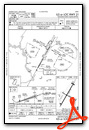
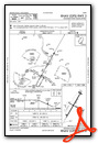
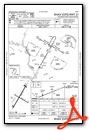
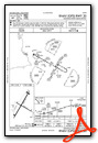
Instrument Approach Procedure (IAP) Charts

Nearby Airports with Instrument Procedures
| ID | Name | Heading / Distance | ||
|---|---|---|---|---|
 |
KCWA | Central Wisconsin Airport | 337° | 15.1 |
|
KISW | Alexander Field South Wood County Airport | 230° | 17.3 |
|
KAUW | Wausau Downtown Airport | 349° | 23.2 |
|
KPCZ | Waupaca Municipal Airport | 119° | 25.4 |
|
KMFI | Marshfield Municipal Airport | 281° | 28.8 |
|
Y50 | Wautoma Municipal Airport | 162° | 31.6 |
|
KCLI | Clintonville Municipal Airport | 082° | 34.5 |
|
63C | Adams County Legion Field Airport | 197° | 36.8 |
|
KDAF | Necedah Airport | 218° | 38.9 |
|
KRRL | Merrill Municipal Airport | 348° | 40.0 |
|
KAIG | Langlade County Airport | 025° | 40.7 |
|
KVIQ | Neillsville Municipal Airport | 271° | 42.1 |
Airport Images

By: harleyman1962@g...


