Login
Register
TLH
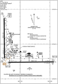
Tallahassee International Airport
Official FAA Data Effective 2025-12-25 0901Z
VFR Chart of KTLH
Sectional Charts at SkyVector.com
IFR Chart of KTLH
Enroute Charts at SkyVector.com
Location Information for KTLH
Coordinates: N30°23.81' / W84°21.05'Located 04 miles SW of Tallahassee, Florida on 2485 acres of land. View all Airports in Florida.
Surveyed Elevation is 83 feet MSL.
Operations Data
|
|
Airport Communications
| ATIS: | 119.45 239.25 |
|---|---|
| ASOS: | 119.45 Tel. 850-203-0697 |
| TALLAHASSEE TOWER: | 118.7 257.8 |
| TALLAHASSEE GROUND: | 121.9 348.6 |
| TALLAHASSEE APPROACH: | 117.5T 128.7 ;181-360 133.85 135.8 ;001-180 254.3 ;181-360 317.4 ;001-180 354.1 |
| TALLAHASSEE DEPARTURE: | 128.7 ;181-360 133.85 135.8 ;001-180 254.3 ;181-360 317.4 ;001-180 354.1 |
| IC: | 135.8 ;001-180 317.4 ;001-180 |
| CLEARANCE DELIVERY: | 126.65 275.8 |
| CTAF: | 118.700 |
| UNICOM: | 123.075 |
| CLASS C: | 128.7 ;181-360 135.8 ;001-180 254.3 ;181-360 317.4 ;001-180 |
| EMERG: | 121.5 243.0 |
| AWOS-3PT at 2J9 (16.1 NW): | 118.975 850-627-6264 |
| AWOS-3PT at BGE (37.5 NW): | 121.125 229-248-2104 |
| AWOS-3PT at TVI (38.8 NE): | 119.175 229-225-4336 |
- APCH/DEP SVC PRVDD BY JACKSONVILLE ARTCC ON FREQS 128.625/379.175 (TALLAHASSEE RCAG) WHEN TALLAHASSEE APCH CTL CLSD.
Nearby Navigation Aids
|
| ||||||||||||||||||||||||||||||||||||||||||||||||||||||||||||
Runway 09/27
| Dimensions: | 8000 x 150 feet / 2438 x 46 meters | |
|---|---|---|
| Surface: | Asphalt / Grooved in Good Condition | |
| Weight Limits: | S-120, D-231, ST-445, DT-920
PCR VALUE: 530/F/A/X/T
| |
| Edge Lighting: | High Intensity | |
| Runway 09 | Runway 27 | |
| Coordinates: | N30°23.48' / W84°21.39' | N30°23.49' / W84°19.87' |
| Elevation: | 60.6 | 48.5 |
| Traffic Pattern: | Left | Left |
| Runway Heading: | 89° True | 269° True |
| Markings: | Precision Instrument in good condition. | Precision Instrument in good condition. |
| Glide Slope Indicator | P4L (3.00° Glide Path Angle) | P4L (3.00° Glide Path Angle) |
| RVR Equipment | Touchdown Rollout | Touchdown Rollout |
| Approach Lights: | ALSF2 Standard 2,400 Foot High-intensity Approach Lighting System with sequenced flashers, CATEGORY II or III Configuration. | |
| REIL: | Yes | |
| Centerline Lights: | Yes | Yes |
Runway 18/36
| Dimensions: | 7000 x 150 feet / 2134 x 46 meters | |
|---|---|---|
| Surface: | Asphalt / Grooved in Excellent Condition | |
| Weight Limits: | S-120, D-217, ST-410, DT-862
PCR VALUE: 490/F/A/X/T
| |
| Edge Lighting: | High Intensity | |
| Runway 18 | Runway 36 | |
| Coordinates: | N30°24.75' / W84°21.54' | N30°23.59' / W84°21.53' |
| Elevation: | 83.1 | 56.4 |
| Traffic Pattern: | Left | Left |
| Runway Heading: | 179° True | 359° True |
| Markings: | Precision Instrument in fair condition. | Precision Instrument in fair condition. |
| Glide Slope Indicator | P4L (3.00° Glide Path Angle) | P4L (3.00° Glide Path Angle) |
| RVR Equipment | Rollout | Touchdown |
| Approach Lights: | MALSR 1,400 Foot Medium-intensity Approach Lighting System with runway alignment indicator lights. | |
| REIL: | Yes | |
Services Available
| Fuel: | 100LL (blue), Jet-A |
|---|---|
| Transient Storage: | Hangars,Tiedowns |
| Airframe Repair: | MAJOR |
| Engine Repair: | MAJOR |
| Bottled Oxygen: | HIGH |
| Bulk Oxygen: | HIGH |
| Other Services: | AIR FREIGHT SERVICES,AIR AMBULANCE SERVICES,AVIONICS,CARGO HANDLING SERVICES,CHARTER SERVICE,PILOT INSTRUCTION,AIRCRAFT RENTAL,AIRCRAFT SALES |
Ownership Information
| Ownership: | Publicly owned | |
|---|---|---|
| Owner: | CITY OF TALLAHASSEE | |
| CITY HALL | ||
| TALLAHASSEE, FL 32304 | ||
| 850-891-7802 | ||
| Manager: | DAVID POLLARD | |
| 3300 CAPITAL CIRCLE SW | ||
| TALLAHASSEE, FL 32310 | ||
| 850-891-7802 | ||
Other Remarks
- MOVEMENT AREA OF TWY 'Z' BEGINS AT THE INTXN OF TWY 'B8' & PROCEEDS E TO THE INTXN OF TWY 'B7' THIS TWY IS NOT FOR USE BY ACR OPNS; ASPH BTN TWYS 'B8' & 'A12' IS FOR HEL OPNS; TWY 'Z' FM TWY 'A12' TO THE RAMP IS OPEN TO ACFT WITH WINGSPAN OF 50 FT OR LESS.
- BIRDS ON & INVOF ARPT.
- FOR CD IF UNA TO CTC ON FSS FREQ, CTC TALLAHASSEE APCH AT 850-942-8311, WHEN APCH CLSD CTC JACKSONVILLE ARTCC AT 904-845-1592.
- WHEN ATCT CLSD ACTVT MALSR 36; REIL RWY 9 & 18; PAPI RWY 9, 27, 18 & 36; HIRL RWY 9/27 & 18/36 - CTAF. ALSF2 RWY 27 PRESET ON MED INTST.
Weather Minimums
Instrument Approach Procedure (IAP) Charts
Nearby Airports with Instrument Procedures
| ID | Name | Heading / Distance | ||
|---|---|---|---|---|
 |
2J9 | Quincy Municipal Airport | 318° | 16.1 |
 |
70J | Cairo-Grady County Airport | 018° | 31.1 |
 |
KBGE | Decatur County Industrial Air Park Airport | 336° | 37.5 |
 |
KTVI | Thomasville Regional Airport | 038° | 38.8 |
 |
KFPY | Perry-Foley Airport | 115° | 44.5 |
 |
17J | Donalsonville Municipal Airport | 323° | 45.5 |
 |
4J5 | Quitman Brooks County Airport | 058° | 46.4 |
 |
KCXU | Camilla-Mitchell County Airport | 006° | 49.2 |
 |
KMGR | Moultrie Municipal Airport | 034° | 50.0 |
 |
KMAI | Marianna Municipal Airport | 301° | 50.5 |
 |
KAAF | Apalachicola Regional-Cleve Randolph Field Airport | 221° | 53.3 |
 |
KVLD | Valdosta Regional Airport | 067° | 60.2 |


Comments
Student activity
Slow service but they were very busy with students whom also appear to be manning the tower and ground control positions. I ended up going to the self serve pump after watching the fuel truck operation. The SS pump is 'okay' but could use some TLC. Typical Million Air desk staff. Average.