Login
Register


TLH
Tallahassee International Airport
Official FAA Data Effective 2026-02-19 0901Z
Chart Supplement

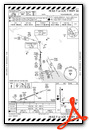
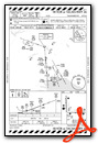
KTLH Airport Diagram

VFR Chart of KTLH
Sectional Charts at SkyVector.com
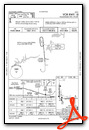
IFR Chart of KTLH
Enroute Charts at SkyVector.com
Location Information for KTLH
Coordinates: N30°23.81' / W84°21.05'Located 04 miles SW of Tallahassee, Florida on 2485 acres of land. View all Airports in Florida.
Surveyed Elevation is 83 feet MSL.
Operations Data
|
|
Airport Communications
| ATIS: | 119.45 239.25 |
|---|---|
| ASOS: | 119.45 Tel. 850-203-0697 |
| TALLAHASSEE TOWER: | 118.7 257.8 |
| TALLAHASSEE GROUND: | 121.9 348.6 |
| TALLAHASSEE APPROACH: | 117.5T 128.7 ;181-360 133.85 135.8 ;001-180 254.3 ;181-360 317.4 ;001-180 354.1 |
| TALLAHASSEE DEPARTURE: | 128.7 ;181-360 133.85 135.8 ;001-180 254.3 ;181-360 317.4 ;001-180 354.1 |
| IC: | 135.8 ;001-180 317.4 ;001-180 |
| CLEARANCE DELIVERY: | 126.65 275.8 |
| UNICOM: | 123.075 |
| CTAF: | 118.700 |
| EMERG: | 121.5 243.0 |
| CLASS C: | 128.7 ;181-360 135.8 ;001-180 254.3 ;181-360 317.4 ;001-180 |
| AWOS-3PT at 2J9 (16.1 NW): | 118.975 850-627-6264 |
| AWOS-3PT at BGE (37.5 NW): | 121.125 229-248-2104 |
| AWOS-3PT at TVI (38.8 NE): | 119.175 229-225-4336 |
- APCH/DEP SVC PRVDD BY JACKSONVILLE ARTCC ON FREQS 128.625/379.175 (TALLAHASSEE RCAG) WHEN TALLAHASSEE APCH CTL CLSD.
Nearby Navigation Aids
|
| ||||||||||||||||||||||||||||||||||||||||||||||||||||||||||||


Runway 09/27
| Dimensions: | 8000 x 150 feet / 2438 x 46 meters | |
|---|---|---|
| Surface: | Asphalt / Grooved in Good Condition | |
| Weight Limits: | S-120, D-231, ST-445, DT-920
PCR VALUE: 530/F/A/X/T
| |
| Edge Lighting: | High Intensity | |
| Runway 09 | Runway 27 | |
| Coordinates: | N30°23.48' / W84°21.39' | N30°23.49' / W84°19.87' |
| Elevation: | 60.6 | 48.5 |
| Traffic Pattern: | Left | Left |
| Runway Heading: | 89° True | 269° True |
| Markings: | Precision Instrument in good condition. | Precision Instrument in good condition. |
| Glide Slope Indicator | P4L (3.00° Glide Path Angle) | P4L (3.00° Glide Path Angle) |
| RVR Equipment | Touchdown Rollout | Touchdown Rollout |
| Approach Lights: | ALSF2 Standard 2,400 Foot High-intensity Approach Lighting System with sequenced flashers, CATEGORY II or III Configuration. | |
| REIL: | Yes | |
| Centerline Lights: | Yes | Yes |
Runway 18/36
| Dimensions: | 7000 x 150 feet / 2134 x 46 meters | |
|---|---|---|
| Surface: | Asphalt / Grooved in Excellent Condition | |
| Weight Limits: | S-120, D-217, ST-410, DT-862
PCR VALUE: 490/F/A/X/T
| |
| Edge Lighting: | High Intensity | |
| Runway 18 | Runway 36 | |
| Coordinates: | N30°24.75' / W84°21.54' | N30°23.59' / W84°21.53' |
| Elevation: | 83.1 | 56.4 |
| Traffic Pattern: | Left | Left |
| Runway Heading: | 179° True | 359° True |
| Markings: | Precision Instrument in fair condition. | Precision Instrument in fair condition. |
| Glide Slope Indicator | P4L (3.00° Glide Path Angle) | P4L (3.00° Glide Path Angle) |
| RVR Equipment | Rollout | Touchdown |
| Approach Lights: | MALSR 1,400 Foot Medium-intensity Approach Lighting System with runway alignment indicator lights. | |
| REIL: | Yes | |
Services Available
| Fuel: | 100LL (blue), Jet-A |
|---|---|
| Transient Storage: | Hangars,Tiedowns |
| Airframe Repair: | MAJOR |
| Engine Repair: | MAJOR |
| Bottled Oxygen: | HIGH |
| Bulk Oxygen: | HIGH |
| Other Services: | AIR FREIGHT SERVICES,AIR AMBULANCE SERVICES,AVIONICS,CARGO HANDLING SERVICES,CHARTER SERVICE,PILOT INSTRUCTION,AIRCRAFT RENTAL,AIRCRAFT SALES |
Ownership Information
| Ownership: | Publicly owned | |
|---|---|---|
| Owner: | CITY OF TALLAHASSEE | |
| CITY HALL | ||
| TALLAHASSEE, FL 32304 | ||
| 850-891-7802 | ||
| Manager: | DAVID POLLARD | |
| 3300 CAPITAL CIRCLE SW | ||
| TALLAHASSEE, FL 32310 | ||
| 850-891-7802 | ||
Other Remarks
- MOVEMENT AREA OF TWY 'Z' BEGINS AT THE INTXN OF TWY 'B8' & PROCEEDS E TO THE INTXN OF TWY 'B7' THIS TWY IS NOT FOR USE BY ACR OPNS; ASPH BTN TWYS 'B8' & 'A12' IS FOR HEL OPNS; TWY 'Z' FM TWY 'A12' TO THE RAMP IS OPEN TO ACFT WITH WINGSPAN OF 50 FT OR LESS.
- BIRDS ON & INVOF ARPT.
- FOR CD IF UNA TO CTC ON FSS FREQ, CTC TALLAHASSEE APCH AT 850-942-8311, WHEN APCH CLSD CTC JACKSONVILLE ARTCC AT 904-845-1592.
- WHEN ATCT CLSD ACTVT MALSR 36; REIL RWY 9 & 18; PAPI RWY 9, 27, 18 & 36; HIRL RWY 9/27 & 18/36 - CTAF. ALSF2 RWY 27 PRESET ON MED INTST.
Weather Minimums

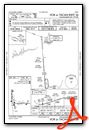
Instrument Approach Procedure (IAP) Charts


Nearby Airports with Instrument Procedures
| ID | Name | Heading / Distance | ||
|---|---|---|---|---|
 |
2J9 | Quincy Municipal Airport | 318° | 16.1 |
|
70J | Cairo-Grady County Airport | 018° | 31.1 |
|
KBGE | Decatur County Industrial Air Park Airport | 336° | 37.5 |
|
KTVI | Thomasville Regional Airport | 038° | 38.8 |
|
KFPY | Perry-Foley Airport | 115° | 44.5 |
|
17J | Donalsonville Municipal Airport | 323° | 45.5 |
|
4J5 | Quitman Brooks County Airport | 058° | 46.4 |
|
KCXU | Camilla-Mitchell County Airport | 006° | 49.2 |
|
KMGR | Moultrie Municipal Airport | 034° | 50.0 |
|
KMAI | Marianna Municipal Airport | 301° | 50.5 |
|
KAAF | Apalachicola Regional-Cleve Randolph Field Airport | 221° | 53.3 |
|
KVLD | Valdosta Regional Airport | 067° | 60.2 |
Fuel Providers

Airport Images
Do you have a recent image of this airport? Upload it here!


Comments
Student activity
Slow service but they were very busy with students whom also appear to be manning the tower and ground control positions. I ended up going to the self serve pump after watching the fuel truck operation. The SS pump is 'okay' but could use some TLC. Typical Million Air desk staff. Average.