Login
Register


STK
Sterling Municipal Airport
Official FAA Data Effective 2026-01-22 0901Z
Chart Supplement

VFR Chart of KSTK
Sectional Charts at SkyVector.com
IFR Chart of KSTK
Enroute Charts at SkyVector.com
Location Information for KSTK
Coordinates: N40°36.86' / W103°15.86'Located 03 miles W of Sterling, Colorado on 340 acres of land. View all Airports in Colorado.
Surveyed Elevation is 4037 feet MSL.
Operations Data
|
|
Airport Communications
| AWOS-3: | 118.525 Tel. 970-526-3009 |
|---|---|
| UNICOM: | 122.800 |
| CTAF: | 122.800 |
| ASOS at AKO (26.5 S): | 135.475 970-345-2320 |
| AWOS-3PT at FMM (30.0 SW): | 132.95 970-867-1992 |
| ASOS at SNY (31.7 NE): | 125.775 308-254-3525 |
- APCH/DEP CTL SVC PRVDD BY DENVER (ZDV) ON FREQS 118.475/225.4 (BRUSH/B/ RCAG).
Nearby Navigation Aids
|
| ||||||||||||||||||||||||||||||||||||||||||||||||||||||||||||


Runway 15/33
| Dimensions: | 5201 x 75 feet / 1585 x 23 meters | |
|---|---|---|
| Surface: | Asphalt in Good Condition | |
| Weight Limits: | S-30 | |
| Edge Lighting: | Medium Intensity | |
| Runway 15 | Runway 33 | |
| Coordinates: | N40°37.31' / W103°16.02' | N40°36.49' / W103°15.69' |
| Elevation: | 4037.5 | 4025.6 |
| Traffic Pattern: | Left | Left |
| Runway Heading: | 163° True | 343° True |
| Markings: | Non-Precision Instrument in good condition. | Precision Instrument in good condition. |
| Glide Slope Indicator | P2L (3.00° Glide Path Angle) | P2L (3.00° Glide Path Angle) |
| REIL: | Yes | Yes |
| Obstacles: | 31 ft Tree 608 ft from runway, 266 ft right of center | |
Runway 04/22
| Dimensions: | 2809 x 150 feet / 856 x 46 meters | |
|---|---|---|
| Surface: | Turf-Gravel in Fair Condition VARMINT HOLES NEAR RWY 04 END. | |
| Runway 04 | Runway 22 | |
| Coordinates: | N40°36.62' / W103°16.07' | N40°36.95' / W103°15.64' |
| Elevation: | 4032.2 | 4028.7 |
| Runway Heading: | 45° True | 225° True |
| Markings: | in fair condition. | in fair condition. |
| Obstacles: | 16 ft Road 139 ft from runway, 7 ft left of center | 48 ft Tree 614 ft from runway, 34 ft right of center |
Services Available
| Fuel: | 100LL (blue), Jet-A |
|---|---|
| Transient Storage: | Hangars,Tiedowns |
| Airframe Repair: | NOT AVAILABLE |
| Engine Repair: | NOT AVAILABLE |
| Bottled Oxygen: | NOT AVAILABLE |
| Bulk Oxygen: | NOT AVAILABLE |
| Other Services: | CROP DUSTING SERVICES |
Ownership Information
| Ownership: | Publicly owned | |
|---|---|---|
| Owner: | CITY OF STERLING | |
| P. O. BOX 4000 | ||
| STERLING, CO 80751 | ||
| 970-522-9700 | ||
| Manager: | CHARLIE MAY | |
| 16562 HWY 14 | ||
| STERLING, CO 80751 | ||
| 970-522-0417 | ||
Other Remarks
- FOR CD CTC DENVER ARTCC AT 303-651-4257.
- RWY 04 DEP HAS 8 FT FENCE 155 FT FM DEP END OF RWY.
- TWY & TRML TIEDOWN AREA MKD WITH BLUE REFLECTORS.
- AEROBATIC OPS ON AND INVOF ARPT.
- BE ALERT; INTENSIVE USAF STUDENT TRG INVOF KCOS & KPUB ARPRTS.
- INTENSIVE AG OPS MAR-SEPT.
- RWY 4/22 SOFT AND ROUGH WHEN WET.
- MKG TYPE - COND: RWY 04/22 ENDS MKD WITH RED/GREEN REFLECTORS.
- WHEN ATCT CLSD ACTVT REIL RWY 15 & 33; MIRL RWY 15/33 - CTAF. PAPI RWY 15 & 33 OPR CONSLY. INCR MIRL INTST - CTAF.
Weather Minimums

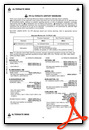
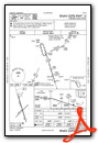
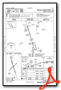
Instrument Approach Procedure (IAP) Charts
Nearby Airports with Instrument Procedures
| ID | Name | Heading / Distance | ||
|---|---|---|---|---|
 |
KAKO | Colorado Plains Regional Airport | 175° | 26.4 |
|
KFMM | Fort Morgan Municipal Airport | 236° | 29.8 |
|
KSNY | Sidney Municipal/Lloyd W Carr Field Airport | 023° | 31.8 |
|
KIBM | Kimball Municipal/Robert E Arraj Field Airport | 331° | 39.2 |
|
2V6 | Yuma Municipal Airport | 140° | 39.6 |
|
KHEQ | Holyoke Airport | 093° | 45.4 |
|
82V | Pine Bluffs Municipal Airport | 309° | 51.1 |
|
2V5 | Wray Municipal Airport | 122° | 56.1 |
|
KOKS | Garden County/King Rhiley Field Airport | 040° | 62.7 |
|
KGXY | Greeley-Weld County Airport | 260° | 63.5 |
|
KGGF | Grant Municipal Airport | 077° | 71.5 |
|
KOGA | Searle Field Airport | 065° | 74.5 |
Airport Images

By: brb
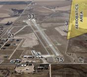
By: STK


Comments
Really Nice Stop Over
Excellent runway and ramp. Fuel available, but no self serve. Really nice pilots lounge with WiFi, snacks, and drinks. I was tempted to move in. Friendly and helpful airport manager. Right on the edge of town. Courtesy car available.