Login
Register


RAS
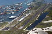
Mustang Beach Airport
Official FAA Data Effective 2026-02-19 0901Z
Chart Supplement

VFR Chart of KRAS
Sectional Charts at SkyVector.com
IFR Chart of KRAS
Enroute Charts at SkyVector.com
Location Information for KRAS
Coordinates: N27°48.71' / W97°5.33'Located 02 miles SW of Port Aransas, Texas on 30 acres of land. View all Airports in Texas.
Surveyed Elevation is 5 feet MSL.
Operations Data
|
|
Airport Communications
| AWOS-3: | 118.425 Tel. 361-749-0537 |
|---|---|
| CORPUS APPROACH: | 125.4 307.9 |
| CORPUS DEPARTURE: | 125.4 307.9 |
| CTAF: | 122.900 |
| AWOS-3 at TFP (9.0 NW): | 118.775 361-758-8961 |
| ATIS at NGP (12.9 SW): | 127.9 |
| ASOS at RKP (16.6 N): | 119.275 361-729-2372 |
Nearby Navigation Aids
|
| ||||||||||||||||||||||||||||||||||||


Runway 12/30
| Dimensions: | 3482 x 70 feet / 1061 x 21 meters | |
|---|---|---|
| Surface: | Asphalt in Excellent Condition | |
| Edge Lighting: | Medium Intensity | |
| Runway 12 | Runway 30 | |
| Coordinates: | N27°48.88' / W97°5.59' | N27°48.54' / W97°5.06' |
| Elevation: | 4.4 | 4.5 |
| Traffic Pattern: | Left | Left |
| Runway Heading: | 125° True | 305° True |
| Markings: | Non-Precision Instrument in good condition. | Non-Precision Instrument in good condition. |
| Glide Slope Indicator | P2L (3.00° Glide Path Angle) | P2L (3.20° Glide Path Angle) |
| Obstacles: | OBSTN CLNC SLOPE 30:1 TO DSPLCD THR. |
38 ft Power Line 465 ft from runway, 325 ft right of center |
Services Available
| Fuel: | 100LL (blue) |
|---|---|
| Transient Storage: | Tiedowns |
| Airframe Repair: | NOT AVAILABLE |
| Engine Repair: | NOT AVAILABLE |
| Bottled Oxygen: | NOT AVAILABLE |
| Bulk Oxygen: | NOT AVAILABLE |
| Other Services: | PARACHUTE JUMP ACTIVITY |
Ownership Information
| Ownership: | Publicly owned | |
|---|---|---|
| Owner: | CITY OF PORT ARANSAS | |
| 710 W. AVE A | ||
| PORT ARANSAS, TX 78373-4128 | ||
| 361-749-4111 | ||
| Manager: | CHRIS SHANKLIN | |
| 710 W. AVE A | ||
| PORT ARANSAS, TX 78373-4128 | ||
| 361-749-4008 | ||
Other Remarks
- RWY 12, 3 FT DROP OFF 40 FM RWY END.
- RWY 30, 36 FT PLINE 1135 FT DSTC. 50 FT PLINE 1770 FT DSTC.
- FOR CD CTC CORPUS CHRISTI APCH AT 361-299-4230.
- 0LL FUEL 24 HR SELF SERV.
Weather Minimums


Instrument Approach Procedure (IAP) Charts


Nearby Airports with Instrument Procedures
| ID | Name | Heading / Distance | ||
|---|---|---|---|---|
 |
KTFP | Ingleside Regional Airport | 312° | 8.9 |
|
KNGP | Corpus Christi NAS (Truax Field) Airport | 236° | 12.9 |
|
KRKP | Aransas County Airport | 008° | 16.6 |
|
KCRP | Corpus Christi International Airport | 263° | 22.1 |
|
T69 | Sinton Airport | 299° | 27.7 |
|
KRBO | Nueces County Airport | 266° | 32.1 |
|
KNQI | Kingsville NAS Airport | 244° | 42.5 |
|
TX2 | Chase Field Industrial Airport | 317° | 44.8 |
|
KBEA | Beeville Municipal Airport | 311° | 49.9 |
|
KALI | Alice International Airport | 265° | 50.1 |
|
KNOG | Orange Grove Nalf Airport | 275° | 51.0 |
|
KIKG | Kleberg County Airport | 252° | 52.6 |
Airport Images

By: paolobovo
By: flakeyswilson


Comments
Transportation Options
There are no courtesy cars available at KRAS, but there is a bus you can take.
We were however, able to rent a 4x4 Trailblazer from VFRCAR.com, 800-481-2624.
transportation
You can also rent a 4 or 6 seat golf cart 1 block away or delivered if used overnight! 361-217-0703
transportation
No rental car companies are currently available - including VFRCARS as mentioned in an earlier comment. I recommend Coastal Ed's golf cart rentals, they'll do an airport dropoff/pickup, 361-749-7001.