Login
Register
1B1
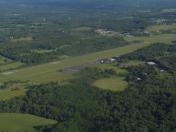
Columbia County Airport
Official FAA Data Effective 2024-10-31 0901Z
VFR Chart of 1B1
Sectional Charts at SkyVector.com
IFR Chart of 1B1
Enroute Charts at SkyVector.com
Location Information for 1B1
Coordinates: N42°17.48' / W73°42.62'Located 04 miles NE of Hudson, New York on 357 acres of land. View all Airports in New York.
Surveyed Elevation is 198 feet MSL.
Operations Data
|
|
Airport Communications
| AWOS-3: | 133.525 Tel. 518-828-2577 |
|---|---|
| ALBANY APPROACH: | 132.825 307.2 |
| ALBANY DEPARTURE: | 132.825 307.2 |
| CTAF: | 123.050 |
| UNICOM: | 123.050 |
| ASOS at PSF (20.4 NE): | 135.375 413-499-3273 |
| ASOS at ALB (27.7 N): | 120.45 518-464-6423 |
| D-ATIS at ALB (27.8 N): | 120.45 |
Nearby Navigation Aids
|
| ||||||||||||||||||||||||||||||||||||||||||||||||||||||||||||
Runway 03/21
| Dimensions: | 5350 x 100 feet / 1631 x 30 meters | |
|---|---|---|
| Surface: | Asphalt / Grooved in Excellent Condition | |
| Weight Limits: | 29 /F/C/X/T, S-69, D-111, ST-358 | |
| Edge Lighting: | Medium Intensity | |
| Runway 03 | Runway 21 | |
| Coordinates: | N42°17.05' / W73°42.74' | N42°17.91' / W73°42.50' |
| Elevation: | 198.1 | 194.0 |
| Traffic Pattern: | Left | Left |
| Runway Heading: | 11° True | 191° True |
| Displaced Threshold: | 160 Feet | |
| Markings: | Non-Precision Instrument in good condition. | Non-Precision Instrument in good condition. |
| Glide Slope Indicator | P4L (3.00° Glide Path Angle) | P4R (3.52° Glide Path Angle) |
| REIL: | Yes | Yes |
| Obstacles: | 55 ft Tree 610 ft from runway, 107 ft left of center | 39 ft Tree 412 ft from runway, 238 ft right of center |
Services Available
| Fuel: | 100 (green), 100LL (blue), Jet A-1+ |
|---|---|
| Transient Storage: | Hangars,Tiedowns |
| Airframe Repair: | MAJOR |
| Engine Repair: | MINOR |
| Bottled Oxygen: | HIGH |
| Bulk Oxygen: | HIGH |
| Other Services: | CHARTER SERVICE,PILOT INSTRUCTION |
Ownership Information
| Ownership: | Publicly owned | |
|---|---|---|
| Owner: | COUNTY OF COLUMBIA | |
| 401 STATE STREET | ||
| HUDSON, NY 12534 | ||
| 518-828-7011 | ||
| Manager: | BRIAN MCDONALD | |
| 401 STATE STREET, 178 ROUTE 23B | ||
| HUDSON, NY 12534 | ||
| 518-828-0871 | ||
Other Remarks
- FOR CD CTC ALBANY APCH AT 518-862-2299.
- RWY 21 DSGND CALM WIND RWY.
- WILDLIFE ON AND INVOF ARPT.
- 0LL 100LL SELF-SVC AVBL 24 HRS.
- ACTVT REIL RWY 03 & 21; MIRL RWY 03/21 - CTAF.
Weather Minimums
Instrument Approach Procedure (IAP) Charts
Nearby Airports with Instrument Procedures
| ID | Name | Heading / Distance | ||
|---|---|---|---|---|
 |
KGBR | Walter J Koladza Airport | 115° | 15.1 |
 |
4B0 | South Albany Airport | 341° | 17.1 |
 |
KPSF | Pittsfield Municipal Airport | 066° | 20.4 |
 |
20N | Kingston-Ulster Airport | 211° | 21.6 |
 |
KALB | Albany International Airport | 351° | 27.8 |
 |
KAQW | Harriman-and-West Airport | 044° | 34.1 |
 |
KSCH | Schenectady County Airport | 343° | 35.0 |
 |
44N | Sky Acres Airport | 182° | 35.0 |
 |
KPOU | Hudson Valley Regional Airport | 191° | 40.6 |
 |
KDDH | William H Morse State Airport | 029° | 41.4 |
 |
KBAF | Westfield-Barnes Regional Airport | 099° | 45.0 |
 |
N89 | Joseph Y Resnick Airport | 221° | 45.0 |


