Login
Register


Y55
Crandon/Steve Conway Municipal Airport
Official FAA Data Effective 2025-02-20 0901Z
Chart Supplement

VFR Chart of Y55
Sectional Charts at SkyVector.com
IFR Chart of Y55
Enroute Charts at SkyVector.com
Location Information for Y55
Coordinates: N45°31.36' / W88°55.71'Located 03 miles SW of Crandon, Wisconsin on 259 acres of land. View all Airports in Wisconsin.
Surveyed Elevation is 1650 feet MSL.
Operations Data
|
|
Airport Communications
| CTAF: | 122.900 |
|---|---|
| AWOS-3 at AIG (23.4 S): | 119.075 715-627-2869 |
| ASOS at RHI (24.2 W): | 126.825 715-362-7980 |
| AWOS-3 at EGV (28.4 NW): | 118.325 715-479-1465 |
- APCH/DEP SVC PRVDD BY MINNEAPOLIS ARTCC ON FREQS 133.65/281.5 (RHINELANDER RCAG).
Nearby Navigation Aids
|
| ||||||||||||||||||||||||||||||||||||||||||||||||


Runway 12/30
| Dimensions: | 3550 x 75 feet / 1082 x 23 meters | |
|---|---|---|
| Surface: | Asphalt in Fair Condition | |
| Weight Limits: | S-12 | |
| Edge Lighting: | Medium Intensity | |
| Runway 12 | Runway 30 | |
| Coordinates: | N45°31.54' / W88°56.25' | N45°31.32' / W88°55.48' |
| Elevation: | 1649.8 | 1627.5 |
| Traffic Pattern: | Left | Left |
| Markings: | Non-Precision Instrument in poor condition. | Non-Precision Instrument in poor condition. |
| Obstacles: | 44 ft Trees 730 ft from runway, 300 ft left of center | |
Runway 01/19
| Dimensions: | 2742 x 100 feet / 836 x 30 meters | |
|---|---|---|
| Surface: | Turf in Good Condition | |
| Runway 01 | Runway 19 | |
| Coordinates: | N45°31.04' / W88°55.54' | N45°31.49' / W88°55.47' |
| Elevation: | 1614.5 | 1626.8 |
| Traffic Pattern: | Left | Left |
Services Available
| Fuel: | NONE |
|---|---|
| Transient Storage: | Tiedowns |
| Airframe Repair: | NONE |
| Engine Repair: | NONE |
| Bottled Oxygen: | NONE |
| Bulk Oxygen: | NONE |
Ownership Information
| Ownership: | Publicly owned | |
|---|---|---|
| Owner: | CITY OF CRANDON | |
| 601 W. WASHINGTON ST, PO BOX 335 | ||
| CRANDON, WI 54520 | ||
| 715-478-2400 | ||
| Manager: | TIM BAHR | |
| 4928 E LAKEVIEW ST | ||
| CRANDON, WI 54520 | ||
| 715-902-0188 | ||
Other Remarks
- OCNL DEER ON & INVOF ARPT.
- FOR CD CTC MINNEAPOLIS ARTCC AT 651-463-5588.
- MKD WITH YELLOW CONES.
- MARKINGS FADED.
- MKD WITH YELLOW CONES.
- MARKINGS FADED.
- MIRL RWY 12/30 PRESET TO LOW SS-SR, INCR INTST AND ACTVT - CTAF.
Weather Minimums
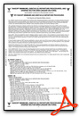
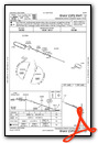
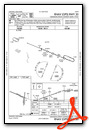
Instrument Approach Procedure (IAP) Charts
Nearby Airports with Instrument Procedures
| ID | Name | Heading / Distance | ||
|---|---|---|---|---|
 |
KAIG | Langlade County Airport | 199° | 23.4 |
|
KRHI | Rhinelander/Oneida County Airport | 286° | 23.6 |
|
KEGV | Eagle River Union Airport | 329° | 28.4 |
|
KTKV | Tomahawk Regional Airport | 265° | 37.1 |
|
KRRL | Merrill Municipal Airport | 239° | 38.5 |
|
KIMT | Ford Airport | 062° | 38.6 |
|
KLNL | Kings Land O' Lakes Airport | 342° | 39.7 |
|
KARV | Lakeland/Noble F Lee Memorial Field Airport | 306° | 41.6 |
|
KAUW | Wausau Downtown Airport | 219° | 46.5 |
|
KEZS | Shawano Municipal Airport | 160° | 46.8 |
|
D25 | Manitowish Waters Airport | 312° | 53.7 |
|
KCWA | Central Wisconsin Airport | 215° | 54.6 |
Airport Images
Do you have a recent image of this airport? Upload it here!


