Login
Register
JLN
Joplin Regional Airport
Official FAA Data Effective 2024-12-26 0901Z
From the Flight Deck
VFR Chart of KJLN
Sectional Charts at SkyVector.com
IFR Chart of KJLN
Enroute Charts at SkyVector.com
Location Information for KJLN
Coordinates: N37°9.19' / W94°29.93'Located 04 miles N of Joplin, Missouri on 970 acres of land. View all Airports in Missouri.
Surveyed Elevation is 977 feet MSL.
Operations Data
|
|
Airport Communications
| ATIS: | 120.85 |
|---|---|
| ASOS: | Tel. 417-623-8892 |
| JOPLIN TOWER: | 119.8 |
| JOPLIN GROUND: | 121.6 |
| UNICOM: | 122.950 |
| CTAF: | 119.800 |
| AWOS-3T at PTS (21.1 NW): | 118.775 620-230-5654 |
| AWOS-3PT at MIO (23.6 SW): | 119.675 918-544-6164 |
| AWOS-3 at HFJ (27.6 SE): | 118.275 417-476-2613 |
- APCH/DEP SVC PRVDD BY KANSAS CITY ARTCC ON FREQS 128.6/282.325 (EDNA RCAG).
Nearby Navigation Aids
|
| ||||||||||||||||||||||||||||||||||||||||||||||||
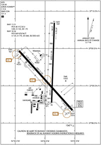
Runway 18/36
| Dimensions: | 6502 x 100 feet / 1982 x 30 meters | |
|---|---|---|
| Surface: | Concrete / Grooved in Excellent Condition | |
| Weight Limits: | S-120, D-175, ST-268, DT-652
PCR VALUE: 569/R/D/W/T
| |
| Edge Lighting: | High Intensity | |
| Runway 18 | Runway 36 | |
| Coordinates: | N37°9.84' / W94°29.84' | N37°8.77' / W94°29.89' |
| Elevation: | 949.4 | 971.1 |
| Traffic Pattern: | Left | Left |
| Runway Heading: | 182° True | 2° True |
| Declared Distances: | TORA:6499 TODA:6499 ASDA:6499 LDA:6499 | TORA:6499 TODA:6499 ASDA:6499 LDA:6499 |
| Markings: | Precision Instrument in good condition. | Non-Precision Instrument in good condition. |
| Glide Slope Indicator | P4L (3.00° Glide Path Angle) | P4L (3.00° Glide Path Angle) |
| RVR Equipment | Touchdown | Rollout |
| Approach Lights: | MALSR 1,400 Foot Medium-intensity Approach Lighting System with runway alignment indicator lights. | |
| Obstacles: | 15 ft Pole 675 ft from runway, 400 ft right of center | |
Runway 13/31
| Dimensions: | 6501 x 150 feet / 1982 x 46 meters | |
|---|---|---|
| Surface: | Asphalt / Grooved in Good Condition | |
| Weight Limits: | 40 /F/C/X/U, S-80, D-105, ST-170 | |
| Edge Lighting: | High Intensity | |
| Runway 13 | Runway 31 | |
| Coordinates: | N37°9.47' / W94°30.44' | N37°8.67' / W94°29.54' |
| Elevation: | 947.2 | 976.7 |
| Traffic Pattern: | Left | Left |
| Runway Heading: | 138° True | 318° True |
| Displaced Threshold: | 388 Feet | 299 Feet |
| Declared Distances: | TORA:6500 TODA:6500 ASDA:6201 LDA:5813 | TORA:6500 TODA:6500 ASDA:6112 LDA:5813 |
| Markings: | Precision Instrument in fair condition. | Non-Precision Instrument in fair condition. |
| Glide Slope Indicator | P4L (3.00° Glide Path Angle) | |
| RVR Equipment | Touchdown | |
| Approach Lights: | MALSF 1,400 Foot Medium-intensity Approach Lighting System with sequenced flashers. | ODALS Omnidirectional Approach Lighting System |
| Obstacles: | 36 ft Tree 825 ft from runway, 490 ft right of center APCH RATIO FROM DSPLCD THR 33:1 |
47 ft Tree 1200 ft from runway, 300 ft left of center APCH RATIO FROM DSPLCD THR 32:1 |
Services Available
| Fuel: | 100LL (blue), Jet-A |
|---|---|
| Transient Storage: | Hangars,Tiedowns |
| Airframe Repair: | MAJOR |
| Engine Repair: | MAJOR |
| Bottled Oxygen: | NONE |
| Bulk Oxygen: | LOW |
| Other Services: | AIR FREIGHT SERVICES,AIR AMBULANCE SERVICES,CHARTER SERVICE,PILOT INSTRUCTION,AIRCRAFT RENTAL,AIRCRAFT SALES |
Ownership Information
| Ownership: | Publicly owned | |
|---|---|---|
| Owner: | CITY OF JOPLIN | |
| 602 S. MAIN STREET | ||
| JOPLIN, MO 64802-1355 | ||
| 417-624-0820 | ||
| Manager: | MR. BART STARKEY | |
| 602 S. MAIN STREET | ||
| JOPLIN, MO 64802 | ||
| 417-623-0262 | ||
Other Remarks
- BIRDS ON & INVOF ARPT SPRING & FALL.
- PPR 48 HRS FOR ACFT CARRYING HAZARDOUS OR EXPLOSIVE CARGO.
- FOR CD IF UNA TO CTC ON FSS FREQ, CTC KANSAS CITY ARTCC AT 913-254-8508.
- WHEN ATCT CLSD ACTVT MALSF RWY 13; ODALS RWY 31; PAPI RWY 18; HIRL RWY 13/31 - CTAF. MALSR RWY 18; PAPI RWY 31; HIRL RWY 18/36 - OPR DUSK-DAWN.
Weather Minimums
Instrument Approach Procedure (IAP) Charts
Nearby Airports with Instrument Procedures
| ID | Name | Heading / Distance | ||
|---|---|---|---|---|
 |
KPTS | Atkinson Municipal Airport | 328° | 21.0 |
 |
KEOS | Neosho Hugh Robinson Airport | 165° | 21.2 |
 |
KLLU | Lamar Municipal Airport | 024° | 21.9 |
 |
KMIO | Miami Regional Airport | 232° | 23.7 |
 |
KHFJ | Monett Regional Airport | 122° | 27.6 |
 |
KGMJ | Grove Regional Airport | 199° | 34.7 |
 |
94K | Cassville Municipal Airport | 133° | 39.7 |
 |
2H2 | Jerry Sumners Sr Aurora Municipal Airport | 106° | 40.2 |
 |
KFSK | Fort Scott Municipal Airport | 341° | 40.8 |
 |
KNVD | Nevada Municipal Airport | 012° | 42.9 |
 |
1K8 | South Grand Lake Regional Airport | 214° | 44.0 |
 |
MO3 | Stockton Lake Airport | 046° | 44.6 |


