Login
Register
LXT
Lee's Summit Municipal Airport
Official FAA Data Effective 2024-12-26 0901Z
VFR Chart of KLXT
Sectional Charts at SkyVector.com
IFR Chart of KLXT
Enroute Charts at SkyVector.com
Location Information for KLXT
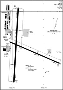
Coordinates: N38°57.55' / W94°22.31'Located 03 miles N of Lee's Summit, Missouri on 553 acres of land. View all Airports in Missouri.
Surveyed Elevation is 1004 feet MSL.
TPA ACFT UNDER 6,000 LBS 1000 FT AGL, ACFT OVER 6,000 LBS 1,500 FT AGL.
Operations Data
|
|
Airport Communications
| ASOS: | 124.175 Tel. 816-347-9807 |
|---|---|
| KANSAS CITY APPROACH: | 118.4 307.35 |
| KANSAS CITY DEPARTURE: | 118.4 307.35 |
| CLEARANCE DELIVERY: | 118.45 |
| BRAYMER STAR: | 120.95 318.1 |
| TYGER STAR: | 120.95 318.1 |
| JHAWK STAR: | 120.95 318.1 |
| CTAF: | 122.800 |
| UNICOM: | 122.800 |
| ATIS at MKC (14.2 NW): | 120.75 |
| ASOS at MKC (14.5 NW): | 120.75 816-329-2843 |
| ASOS at OJC (18.4 W): | 913-780-6969 |
Nearby Navigation Aids
|
| ||||||||||||||||||||||||||||||||||||||||||||||||||||||||||||
Runway 18/36
| Dimensions: | 5501 x 100 feet / 1677 x 30 meters | |
|---|---|---|
| Surface: | Concrete / Grooved in Excellent Condition | |
| Weight Limits: | 22 /R/C/W/T, S-40, D-60 | |
| Edge Lighting: | Medium Intensity | |
| Runway 18 | Runway 36 | |
| Coordinates: | N38°58.04' / W94°22.40' | N38°57.13' / W94°22.47' |
| Elevation: | 995.0 | 986.0 |
| Traffic Pattern: | Right | |
| Runway Heading: | 183° True | 3° True |
| Markings: | Non-Precision Instrument in good condition. | Non-Precision Instrument in good condition. |
| Glide Slope Indicator | P4L (3.00° Glide Path Angle) | P4L (3.00° Glide Path Angle) |
| REIL: | Yes | Yes |
Runway 11/29
| Dimensions: | 4000 x 75 feet / 1219 x 23 meters | |
|---|---|---|
| Surface: | Concrete in Good Condition | |
| Weight Limits: | S-30, D-30 | |
| Edge Lighting: | Medium Intensity | |
| Runway 11 | Runway 29 | |
| Coordinates: | N38°57.62' / W94°22.53' | N38°57.36' / W94°21.75' |
| Elevation: | 991.9 | 1001.6 |
| Traffic Pattern: | Right | |
| Runway Heading: | 113° True | 293° True |
| Markings: | Non-Precision Instrument in good condition. | Non-Precision Instrument in good condition. |
| Glide Slope Indicator | P4L (3.00° Glide Path Angle) | P4R (3.00° Glide Path Angle) |
| REIL: | Yes | Yes |
Services Available
| Fuel: | 100LL (blue), Jet-A, Automotive Gasoline |
|---|---|
| Transient Storage: | Hangars,Tiedowns CTC AMGR FOR RAMP FEES. |
| Airframe Repair: | MAJOR |
| Engine Repair: | MAJOR |
| Bottled Oxygen: | LOW |
| Bulk Oxygen: | NONE |
| Other Services: | PILOT INSTRUCTION,AIRCRAFT RENTAL,ANNUAL SURVEYING |
Ownership Information
| Ownership: | Publicly owned | |
|---|---|---|
| Owner: | CITY OF LEE'S SUMMIT | |
| 220 SE GREEN, P.O. BOX 1600 | ||
| LEES SUMMIT, MO 64063 | ||
| 816-969-1000 | ||
| Manager: | JOEL ARRINGTON | |
| 2751 NE DOUGLAS RD | ||
| LEES SUMMIT, MO 64064 | ||
| 816-969-1186 | ||
Other Remarks
- NO RIGHT TURNS UNDER 2500 FT MSL OR WITHIN 3 MI OF ARPT WHEN DEPARTING ON RWY 29.
- FOR CD CTC KANSAS CITY APCH 118.45 OR 816-329-2710.
- NO LEFT TURNS WITHIN 1/2 MI OF END OF RWY WHEN DEPARTING ON RWY 18.
- NO LEFT TURNS UNDER 2500 FT MSL OR WITHIN 3 MI OF THE ARPT DEPARTING ON RWY 36.
- WILDLIFE ON & INVOF ARPT.
- WHEN WINDS ARE LESS THAN 5 KNOTS USE RWY 18.
- AER 18,36 & 29 ARE NOT MUTUALLY VSB DUE TO TRRN.
- ARPT TRML BLDG OPEN 24 HRS.
- RWY 18/36 GRAD 0.16%, RWY 11/29 GRAD 0.24%
- 0LL 24 HR SELF SERVICE FUEL 100LL & MOGAS. MOBILE FUEL JET A AND 100LL. AFTER HRS FUEL CALL 816-969-1186. CALL OUT FEE.
- ACTVT REIL RWY 18 & 36, 11 & 29; MIRL RWY 11 & 29, 18 & 36 - CTAF. PAPI RWY 11 & 29, 18 & 36 OPR CONSLY.
- TPA ACFT UNDER 6,000 LBS 1000 FT AGL, ACFT OVER 6,000 LBS 1,500 FT AGL.
Weather Minimums
Standard Terminal Arrival (STAR) Charts
Instrument Approach Procedure (IAP) Charts
Departure Procedure (DP) Charts
Nearby Airports with Instrument Procedures
| ID | Name | Heading / Distance | ||
|---|---|---|---|---|
 |
3GV | East Kansas City Airport | 065° | 8.1 |
 |
KMKC | Charles B Wheeler Downtown Airport | 313° | 14.3 |
 |
KOJC | Johnson County Exec Airport | 248° | 18.4 |
 |
KLRY | Lawrence Smith Memorial Airport | 176° | 21.0 |
 |
KGPH | Midwest Ntl Air Center Airport | 007° | 22.6 |
 |
3EX | Excelsior Springs Memorial Airport | 019° | 24.1 |
 |
KIXD | New Century Aircenter Airport | 252° | 25.5 |
 |
KMCI | Kansas City International Airport | 321° | 25.8 |
 |
KRCM | Skyhaven Airport | 111° | 28.7 |
 |
KHIG | Higginsville Industrial Municipal Airport | 077° | 33.2 |
 |
KFLV | Sherman AAF Airport | 314° | 35.2 |
 |
K81 | Miami County Airport | 225° | 35.9 |


