Login
Register
ORF
Norfolk International Airport
Official FAA Data Effective 2024-12-26 0901Z
VFR Chart of KORF
Sectional Charts at SkyVector.com
IFR Chart of KORF
Enroute Charts at SkyVector.com
Location Information for KORF
Coordinates: N36°53.68' / W76°12.07'Located 03 miles NE of Norfolk, Virginia on 1300 acres of land. View all Airports in Virginia.
Surveyed Elevation is 26 feet MSL.
Operations Data
|
|
Airport Communications
| ATIS: | 127.15 (757-464-1390) |
|---|---|
| ASOS: | Tel. 757-460-9348 |
| NORFOLK TOWER: | 120.8 257.8 |
| NORFOLK GROUND: | 121.9 |
| NORFOLK APPROACH: | 118.9 ;010-080, 180-310 335.625 353.7 ;010-080, 180-310 |
| NORFOLK DEPARTURE: | 125.2 363.125 379.1 |
| IC: | 118.9 ;010-080, 180-310 353.7 ;010-080, 180-310 |
| CLEARANCE DELIVERY: | 118.5 |
| DRONE STAR: | 118.9 353.7 |
| PRE TAXI CLNC: | 118.5 |
| TERKS STAR: | 118.9 353.7 |
| CLASS C: | 118.9 ;010-080, 180-310 125.7 ;311-009 353.7 ;010-080, 180-310 379.1 ;311-009 |
| EMERG: | 121.5 243.0 |
| ATIS at NGU (4.9 NW): | 118.425 |
| ASOS at NTU (9.2 SE): | DSN 433-3619 |
| ATIS at NTU (9.2 SE): | 317.6 |
Nearby Navigation Aids
|
| ||||||||||||||||||||||||||||||||||||||||||||||||||||||||||||
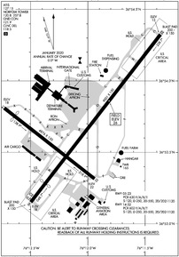
Runway 05/23
| Dimensions: | 9001 x 150 feet / 2744 x 46 meters | |
|---|---|---|
| Surface: | Asphalt-Concrete / Grooved in Fair Condition CONC PTNS: LONGL CRACKS & SPALLING. | |
| Weight Limits: | S-120, D-250, ST-550, DT-1120
PCR VALUE: 630/F/A/X/T
| |
| Edge Lighting: | High Intensity | |
| Runway 05 | Runway 23 | |
| Coordinates: | N36°53.15' / W76°12.50' | N36°54.32' / W76°11.37' |
| Elevation: | 17.7 | 15.0 |
| Traffic Pattern: | Right | Left |
| Runway Heading: | 38° True | 218° True |
| Displaced Threshold: | 1001 Feet | |
| Declared Distances: | TORA:9001 TODA:9001 ASDA:8809 LDA:7809 | TORA:9001 TODA:9001 ASDA:8995 LDA:8995 |
| Markings: | Precision Instrument in good condition. | Precision Instrument in good condition. |
| Glide Slope Indicator | P4L (3.00° Glide Path Angle) | P4L (3.00° Glide Path Angle) |
| RVR Equipment | Touchdown | Rollout |
| Approach Lights: | MALSR 1,400 Foot Medium-intensity Approach Lighting System with runway alignment indicator lights. | MALSR 1,400 Foot Medium-intensity Approach Lighting System with runway alignment indicator lights. |
| Centerline Lights: | Yes | Yes |
| Obstacles: | 41 ft Trees 2100 ft from runway, 380 ft left of center APCH RATIO 50:1 TO DSPLCD THR. |
49 ft Pole 1500 ft from runway, 150 ft right of center RWY 23 +1' FNC 80' FM RY END 400' R 10' FCN 0-200 270' L |
Runway 14/32
| Dimensions: | 4876 x 150 feet / 1486 x 46 meters | |
|---|---|---|
| Surface: | Asphalt / Grooved in Good Condition | |
| Weight Limits: | S-120, D-250, ST-550, DT-1120
PCR VALUE: 602/F/A/X/T
| |
| Edge Lighting: | Medium Intensity | |
| Runway 14 | Runway 32 | |
| Coordinates: | N36°53.81' / W76°12.73' | N36°53.32' / W76°11.94' |
| Elevation: | 17.7 | 21.7 |
| Traffic Pattern: | Right | Left |
| Runway Heading: | 128° True | 308° True |
| Displaced Threshold: | 575 Feet | |
| Declared Distances: | TORA:4876 TODA:4876 ASDA:4876 LDA:4301 | TORA:4876 TODA:4876 ASDA:3901 LDA:3901 |
| Markings: | Non-Precision Instrument in good condition. | Non-Precision Instrument in good condition. |
| Glide Slope Indicator | P2L (3.00° Glide Path Angle) | P2L (3.00° Glide Path Angle) |
| REIL: | Yes | Yes |
| Obstacles: | 61 ft Tree 1226 ft from runway APCH RATIO 26:1 TO DSPLCD THR. |
103 ft Tree 2590 ft from runway, 430 ft left of center |
Services Available
| Fuel: | 100LL (blue), Jet-A |
|---|---|
| Transient Storage: | Hangars,Tiedowns |
| Airframe Repair: | MINOR |
| Engine Repair: | MINOR |
| Bottled Oxygen: | LOW |
| Bulk Oxygen: | HIGH/LOW |
| Other Services: | AVIONICS,CARGO HANDLING SERVICES,CHARTER SERVICE,PILOT INSTRUCTION |
Ownership Information
| Ownership: | Publicly owned | |
|---|---|---|
| Owner: | NORFOLK AIRPORT AUTH | |
| 2200 NORVIEW AVE | ||
| NORFOLK, VA 23518-5807 | ||
| 757-857-3351 | ||
| Manager: | MARK PERRYMAN, PRESIDENT & CEO | |
| 2200 NORVIEW AVE | ||
| NORFOLK, VA 23518-5807 | ||
| 757-857-3344 | POLICE DISPATCH. | |
Other Remarks
- NOISE ABATEMENT PROCEDURES IN EFFECT.
- FLOCKS OF BIRDS ON & INVOF ARPT.
- INTMT AIRFIELD MOWING OPS MAR - NOV.
Weather Minimums
Standard Terminal Arrival (STAR) Charts
Instrument Approach Procedure (IAP) Charts
Departure Procedure (DP) Charts
Nearby Airports with Instrument Procedures
| ID | Name | Heading / Distance | ||
|---|---|---|---|---|
 |
KNGU | Norfolk Ns (Chambers Field) Airport | 301° | 5.0 |
 |
KNTU | Oceana NAS (Apollo Soucek Field) Airport | 117° | 9.2 |
 |
KLFI | Langley AFB Airport | 325° | 13.6 |
 |
KPVG | Hampton Roads Exec Airport | 240° | 13.8 |
 |
KCPK | Chesapeake Regional Airport | 202° | 14.9 |
 |
KPHF | Newport News/Williamsburg International Airport | 315° | 20.0 |
 |
KSFQ | Suffolk Exec Airport | 236° | 23.0 |
 |
KFAF | Felker AAF Airport | 306° | 24.2 |
 |
KONX | Currituck County Regional Airport | 163° | 31.0 |
 |
KJGG | Waltrip Williamsburg Exec Airport Airport | 310° | 32.2 |
 |
KFKN | Franklin Regional Airport | 251° | 35.7 |
 |
KECG | Elizabeth City Cg Air Station/Regional Airport | 178° | 38.0 |


