Login
Register


44KY
Duff Airport
Official FAA Data Effective 2026-01-22 0901Z
VFR Chart of 44KY
Sectional Charts at SkyVector.com
IFR Chart of 44KY
Enroute Charts at SkyVector.com
Location Information for 44KY
Coordinates: N37°21.16' / W83°20.54'Located 02 miles NE of Chavies, Kentucky. View all Airports in Kentucky.
Estimated Elevation is 820 feet MSL.
Operations Data
|
|
Airport Communications
| AWOS-3 at CPF (4.5 NE): | 119.025 606-435-2452 |
|---|---|
| ASOS at JKL (14.5 N): | 118.375 606-252-3918 |
| AWOS-3 at I35 (29.7 S): | 118.35 606-573-9104 |
Nearby Navigation Aids
|
| ||||||||||||||||||||||||||||||||||||||||||||||||||||||||||||


Runway 10/28
LAND RWY 10; DEPART RWY 28. | ||
| Dimensions: | 2300 x 30 feet / 701 x 9 meters | |
|---|---|---|
| Surface: | Asphalt | |
| Runway 10 | Runway 28 | |
Ownership Information
| Ownership: | Privately Owned | |
|---|---|---|
| Owner: | PINE BRANCH COAL SALES, INC. | |
| P.O. BOX 246 | ||
| CHAVIES, KY 41727 | ||
| 606-436-3712 | ||
| Manager: | RYAN DUFF | |
| P.O. BOX 246 | ||
| CHAVIES, KY 41727 | ||
| 606-436-3712 | ||
Other Remarks
- FOR CD CTC INDIANAPOLIS ARTCC AT 317-247-2411.
Nearby Airports with Instrument Procedures
| ID | Name | Heading / Distance | ||
|---|---|---|---|---|
 |
KCPF | Wendell H Ford Airport | 061° | 4.4 |
|
KJKL | Julian Carroll Airport | 004° | 14.5 |
|
I35 | Tucker-Guthrie Memorial Airport | 181° | 29.6 |
|
KLOZ | London/Corbin/Magee Airport | 245° | 38.7 |
|
KPBX | Pike County/Hatcher Field Airport | 071° | 39.1 |
|
KSJS | Big Sandy Regional Airport | 054° | 41.3 |
|
0VG | Lee County Airport | 171° | 42.3 |
|
KLNP | Lonesome Pine Airport | 119° | 44.7 |
|
1A6 | Middlesboro/Bell County Airport | 203° | 48.4 |
|
KRGA | Central Kentucky Regional Airport | 289° | 50.1 |
|
KIOB | Mount Sterling/Montgomery County Airport | 324° | 52.0 |
|
KBYL | Williamsburg-Whitley County Airport | 231° | 53.0 |
Airport Images
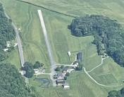
By: Big Orange Bird


