Login
Register


LAA
Southeast Colorado Regional Airport
Official FAA Data Effective 2026-01-22 0901Z
Chart Supplement

VFR Chart of KLAA
Sectional Charts at SkyVector.com
IFR Chart of KLAA
Enroute Charts at SkyVector.com
Location Information for KLAA
Coordinates: N38°4.18' / W102°41.31'Located 03 miles SW of Lamar, Colorado on 557 acres of land. View all Airports in Colorado.
Surveyed Elevation is 3705 feet MSL.
Operations Data
|
|
Airport Communications
| ASOS: | 135.625 Tel. 719-336-3854 |
|---|---|
| UNICOM: | 122.800 |
| CTAF: | 122.800 |
| AWOS-3PT at 8V7 (37.1 S): | 118.975 719-563-1028 |
| ASOS at LHX (38.8 W): | 135.525 719-384-5961 |
| AWOS-3PT at 3K3 (44.7 E): | 119.975 620-384-5869 |
- APCH/DEP CTL SVC PRVDD BY DENVER ARTCC (ZDV) ON FREQS 133.4/377.175 (LA JUNTA RCAG).
Nearby Navigation Aids
|
| ||||||||||||||||||||||||||||||||||||


Runway 18/36
| Dimensions: | 6304 x 100 feet / 1921 x 30 meters | |
|---|---|---|
| Surface: | Concrete / Grooved in Good Condition | |
| Weight Limits: | 12 /R/B/W/U, S-45, D-55, ST-100 | |
| Edge Lighting: | Medium Intensity | |
| Runway 18 | Runway 36 | |
| Coordinates: | N38°4.49' / W102°41.37' | N38°3.47' / W102°41.59' |
| Elevation: | 3678.6 | 3705.3 |
| Traffic Pattern: | Left | Left |
| Runway Heading: | 190° True | 10° True |
| Markings: | Non-Precision Instrument in good condition. | Non-Precision Instrument in good condition. |
| Glide Slope Indicator | V4L (3.00° Glide Path Angle) | P4L (3.00° Glide Path Angle) |
| REIL: | Yes | Yes |
| Obstacles: | 30 ft Road 672 ft from runway | 28 ft Hill 946 ft from runway, 210 ft right of center |
Runway 08/26
| Dimensions: | 5001 x 60 feet / 1524 x 18 meters | |
|---|---|---|
| Surface: | Asphalt / Aggregate Friction Seal Coated in Fair Condition | |
| Weight Limits: | S-35, D-50, ST-95 | |
| Edge Lighting: | Medium Intensity | |
| Runway 08 | Runway 26 | |
| Coordinates: | N38°4.44' / W102°41.61' | N38°4.44' / W102°40.57' |
| Elevation: | 3682.8 | 3689.0 |
| Runway Heading: | 90° True | 270° True |
| Markings: | Basic in good condition. | Basic in good condition. |
| Glide Slope Indicator | P2L (3.00° Glide Path Angle) | P2L (3.00° Glide Path Angle) |
| REIL: | Yes | Yes |
| Obstacles: | 25 ft Road 599 ft from runway | |
Services Available
| Fuel: | 100LL (blue), Jet-A |
|---|---|
| Transient Storage: | Hangars,Tiedowns |
| Airframe Repair: | MAJOR |
| Engine Repair: | MAJOR |
| Bottled Oxygen: | LOW |
| Bulk Oxygen: | LOW |
| Other Services: | CROP DUSTING SERVICES,CHARTER SERVICE,PILOT INSTRUCTION,AIRCRAFT RENTAL,ANNUAL SURVEYING |
Ownership Information
| Ownership: | Publicly owned | |
|---|---|---|
| Owner: | CITY OF LAMAR | |
| 102 EAST PARMENTER | ||
| LAMAR, CO 81052 | ||
| 719-336-4376 | ||
| Manager: | PATRICK MASON | |
| 102 E PARMENTER | ||
| LAMAR, CO 81052 | ||
| 719-336-2002 | ||
Other Remarks
- TOWER 500 FT AGL 4.5 MI SE UNLIGHTED.
- BE ALERT; INTENSIVE USAF STUDENT TRAINING IN VICINITY OF COLORADO SPRINGS & PUEBLO COLORADO.
- FOR CD CTC DENVER ARTCC AT 303-651-4257.
- 0LL 100LL AVBL H24 SELF SVC.
- ACTVT & INCR INTST REIL RWY 08 & 26, RWY 18 & 36; PAPI RWY 08 & 26, RWY 36; VASI RWY 18; MIRL RWY 08/26, 18/36; TWY LGTS - CTAF. ALL LGTS PRESET MED INTST.
Weather Minimums

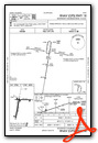
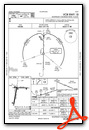
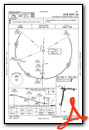
Instrument Approach Procedure (IAP) Charts


Nearby Airports with Instrument Procedures
| ID | Name | Heading / Distance | ||
|---|---|---|---|---|
 |
8V7 | Springfield Municipal Airport | 174° | 36.8 |
|
KLHX | La Junta Municipal Airport | 268° | 38.9 |
|
3K3 | Syracuse-Hamilton County Municipal Airport | 095° | 44.8 |
|
5K2 | Tribune Municipal Airport | 062° | 49.9 |
|
KJHN | Stanton County Municipal Airport | 122° | 53.9 |
|
3K7 | Mark Hoard Memorial Airport | 069° | 67.3 |
|
KULS | Ulysses Airport | 113° | 68.4 |
|
KITR | Kit Carson County Airport | 014° | 72.8 |
|
KEHA | Elkhart-Morton County Airport | 148° | 74.8 |
|
17K | Boise City Airport | 173° | 78.1 |
|
KHQG | Hugoton Municipal Airport | 130° | 83.0 |
|
KLIC | Limon Municipal Airport | 327° | 85.6 |
Airport Images

By: Big Orange Bird


