Login
Register
PVD
Rhode Island Tf Green International Airport
Official FAA Data Effective 2025-11-27 0901Z
VFR Chart of KPVD
Sectional Charts at SkyVector.com
IFR Chart of KPVD
Enroute Charts at SkyVector.com
Location Information for KPVD
Coordinates: N41°43.34' / W71°25.66'Located 06 miles S of Providence, Rhode Island on 1111 acres of land. View all Airports in Rhode Island.
Surveyed Elevation is 54 feet MSL.
Operations Data
|
|
Airport Communications
| D-ATIS: | 124.2 (401-737-3215) |
|---|---|
| ASOS: | 124.2 Tel. 401-734-2818 |
| PROVIDENCE TOWER: | 120.7 257.8 |
| PROVIDENCE GROUND: | 121.9 348.6 |
| PROVIDENCE APPROACH: | 123.675 244.875 |
| PROVIDENCE DEPARTURE: | 123.675 244.875 |
| IC: | 123.675 |
| CLEARANCE DELIVERY: | 126.65 348.6 |
| COMD POST: | 383.3 |
| WIPOR STAR: | 123.675 244.875 |
| CTAF: | 120.700 |
| EMERG: | 121.5 243.0 |
| CLASS C: | 123.675 244.875 |
| ATIS at OQU (7.5 S): | 118.6 |
| AWOS-3PT at OQU (7.8 S): | 118.6 401-294-2197 |
| AWOS-3PT at SFZ (12.0 N): | 120.775 401-334-0324 |
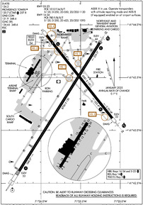
- APCH/DEP SVC PRVDD BY BOSTON ARTCC ON FREQS 124.85/307.9 (WOODSTOCK RCAG) WHEN APCH CTL CLSD.
- ASDE-X IN USE. OPERATE TRANSPONDERS WITH ALTITUDE REPORTING MODE AND ADS-B (IF EQUIPPED) ENABLED ON ALL AIRPORT SURFACES.
Nearby Navigation Aids
|
| ||||||||||||||||||||||||||||||||||||||||||||||||||||||
Runway 05/23
| Dimensions: | 8700 x 150 feet / 2652 x 46 meters | |
|---|---|---|
| Surface: | Asphalt / Grooved in Fair Condition | |
| Weight Limits: | S-120, D-250, ST-550, DT-1120
PCR VALUE: 1010/F/A/X/T
| |
| Edge Lighting: | High Intensity | |
| Runway 05 | Runway 23 | |
| Coordinates: | N41°42.62' / W71°26.28' | N41°43.83' / W71°25.26' |
| Elevation: | 52.9 | 44.3 |
| Traffic Pattern: | Left | Left |
| Runway Heading: | 32° True | 212° True |
| Declared Distances: | TORA:8700 TODA:8700 ASDA:8700 LDA:8700 | TORA:8700 TODA:8700 ASDA:8700 LDA:8700 |
| Markings: | Precision Instrument in good condition. | Precision Instrument in good condition. |
| Glide Slope Indicator | P4R (3.00° Glide Path Angle) | V4L (3.00° Glide Path Angle) |
| RVR Equipment | Touchdown Midfield Rollout | Touchdown Midfield Rollout |
| Approach Lights: | ALSF2 Standard 2,400 Foot High-intensity Approach Lighting System with sequenced flashers, CATEGORY II or III Configuration. | MALSR 1,400 Foot Medium-intensity Approach Lighting System with runway alignment indicator lights. |
| Centerline Lights: | Yes | Yes |
| Obstacles: | 56 ft Trees 2475 ft from runway, 600 ft right of center | 50 ft Trees 2185 ft from runway, 790 ft right of center |
Runway 16/34
| Dimensions: | 6081 x 150 feet / 1853 x 46 meters | |
|---|---|---|
| Surface: | Asphalt / Grooved in Good Condition | |
| Weight Limits: | S-120, D-250, ST-423, DT-1093
PCR VALUE: 780/F/B/X/T
| |
| Edge Lighting: | High Intensity | |
| Runway 16 | Runway 34 | |
| Coordinates: | N41°43.90' / W71°25.93' | N41°43.11' / W71°25.10' |
| Elevation: | 53.7 | 32.8 |
| Traffic Pattern: | Left | Left |
| Runway Heading: | 142° True | 322° True |
| Displaced Threshold: | 565 Feet | |
| Declared Distances: | TORA:6081 TODA:6081 ASDA:6081 LDA:5516 | TORA:6081 TODA:6081 ASDA:6081 LDA:6081 |
| Markings: | Precision Instrument in good condition. | Precision Instrument in good condition. |
| Glide Slope Indicator | P4L (3.00° Glide Path Angle) | P4L (3.00° Glide Path Angle) |
| RVR Equipment | Rollout | Touchdown |
| Approach Lights: | MALSR 1,400 Foot Medium-intensity Approach Lighting System with runway alignment indicator lights. | |
| REIL: | Yes | |
| Obstacles: | 19 ft Pole 560 ft from runway, 200 ft left of center 54 FT TREES 700 FT R OF CNTRLN 2000 FT FM RWY END. 37:1 TO DTHR. |
39 ft Trees 1400 ft from runway, 300 ft right of center |
Services Available
| Fuel: | 100LL (blue), Jet-A |
|---|---|
| Transient Storage: | Hangars,Tiedowns |
| Airframe Repair: | MAJOR |
| Engine Repair: | MAJOR |
| Bottled Oxygen: | NONE |
| Bulk Oxygen: | NONE |
| Other Services: | AIR FREIGHT SERVICES,CARGO HANDLING SERVICES,CHARTER SERVICE,PILOT INSTRUCTION,AIRCRAFT RENTAL,AIRCRAFT SALES |
Ownership Information
| Ownership: | Publicly owned | |
|---|---|---|
| Owner: | STATE OF RHODE ISLAND | |
| RI AIRPORT CORP, 2000 POST RD | ||
| WARWICK, RI 02886 | ||
| 401-691-2000 | ||
| Manager: | IFTIKHAR AHMAD | |
| RI AIRPORT CORP, 2000 POST RD | ||
| WARWICK, RI 02886 | ||
| 401-691-2000 | ||
Other Remarks
- GND VEHICLES MNT CTAF WHEN ATCT CLSD.
- TRML RAMP PROHIBITED FOR USE BY GA.
- TWY V CLSD DLY 2000-0800 BTN RWY 16/34 AND TWY C.
- PARKED ACFT ON THE NE RAMP WEST OF TWY A, BE ALERT. FQT FLT SCHOOL, TSNT JET ACFT, AND VER ACTVTY.
- NE RAMP ACFT WITH WINGSPAN GTR THAN 150 FT RQR GND CREW ASSISTANCE FOR THRU TAXI AND PRKG.
- FOR CD WHEN APCH CLSD CTC BOSTON ARTCC AT 603-879-6859.
- DEER & BIRDS ON & INVOF ARPT.
- TWY A UNEVEN PAVEMENT BTN TWY M & RWY 23.
- 110 FT UNMKD LGT POLES, 2700 FT FM THR RWY 34, 900 FT LEFT OF CNTRLN.
- RUN UP PAD FOR TWY F CLSD TO ACFT WITH WINGSPAN OVER 118 FT.
- NOISE ABATEMENT PROCS IN EFCT. HELS AVOID RESL AREAS WHEN BLW 1000 FT.
- NW RAMP ACFT WITH WINGSPAN GTR THAN 110 FT RQR GND CREW ASSISTANCE FOR THRU TAXI AND PRKG.
- WHEN ATCT CLSD, ALSF-2 BCMS SSALS PRESET MED INTST ONLY. WHEN ATCT CLSD, ACTVT MALSR RWY 23 & 34; REIL RWY 16; PAPI RWY 05, 16 & 34; VASI RWY 23; TDZ RWY 05; CNTLN RWY 5/23; HIRL RWY 5/23 & 16/34 - CTAF.
- ENGINEERED MATERIAL ARRESTING SYSTEM (EMAS) 255 FT IN LENGTH BY 170 FT IN WIDTH LCTD AT DER.
Weather Minimums
Standard Terminal Arrival (STAR) Charts
Instrument Approach Procedure (IAP) Charts
Nearby Airports with Instrument Procedures
| ID | Name | Heading / Distance | ||
|---|---|---|---|---|
 |
KOQU | Quonset State Airport | 174° | 7.5 |
 |
KSFZ | North Central State Airport | 346° | 12.2 |
 |
KUUU | Newport State Airport | 149° | 13.2 |
 |
1B9 | Mansfield Municipal Airport | 031° | 19.6 |
 |
KTAN | Taunton Municipal/King Field Airport | 063° | 20.6 |
 |
KEWB | New Bedford Regional Airport | 097° | 21.3 |
 |
1B6 | Hopedale Industrial Park Airport | 350° | 23.3 |
 |
KWST | Westerly State Airport | 217° | 28.0 |
 |
KOWD | Norwood Memorial Airport | 022° | 30.3 |
 |
KPYM | Plymouth Municipal Airport | 070° | 33.3 |
 |
KIJD | Windham Airport | 272° | 33.8 |
 |
KBID | Block Island State Airport | 191° | 33.9 |


